Archivo:Aksai Chin Sino-Indian border map.png

Ver la imagen en su resolución original (624 × 872 píxeles; tamaño de archivo: 102 kB; tipo MIME: image/png)
Resumen

|
File:Aksai Chin Sino-Indian border map.svg es una versión vectorial de este archivo. Debería usarse esa versión en lugar de este archivo PNG, cuando sea mejor.
File:Aksai Chin Sino-Indian border map.png → File:Aksai Chin Sino-Indian border map.svg
Para más información, lee Ayuda:SVG. |
 |
| Descripción |
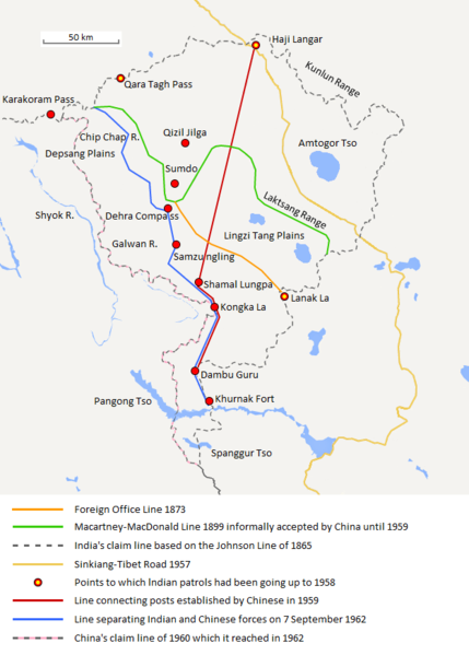
English: The map shows the Indian and Chinese claims of the border in the Aksai Chin region, the Macartney-MacDonald line, the Foreign Office Line, as well as the progress of Chinese forces as they occupied areas during the Sino-Indian War. |
| Fecha | |
| Fuente | Trabajo propio |
| Autor | The Discoverer |
The Macartney-MacDonald line is described as follows: "From the Karakoram Pass the crests of the range run nearly east for about half a degree, and then turn south to a little below the 35th parallel.. Rounding... the source of the Karakash, the line of hills to be followed runs north-east to a point east of Kizil Jilga and from there, in a south-easterly direction, follows the Lak Tsung (Lokzhung) Range until that meets a spur.. which has hitherto been shown on our maps as the eastern boundary of Ladakh.[1]
The Macartney-MacDonald line was never accepted by China, although they informally indicated acceptance on certain occasions:
- Woodman, Dorothy (1969) Himalayan Frontiers: A Political Review of British, Chinese, Indian, and Russian Rivalries, Praeger, p. 102 «The proposed boundary seems never to have been considered in the same form again until Alastair Lamb revived it in 1964.»
- Lamb, Alastair (1965). "Treaties, Maps and the Western Sector of the Sino-Indian Boundary Dispute". The Australian Year Book of International Law. "Unfortunately, the Chinese never replied formally to the note, though they indicated informally on a number of occasions their agreement as to its boundary alignment."
In 1959, Chou confirmed the new Chinese claim line to Nehru.
References: [2] archive copy at the Wayback Machine [3] [4] [5] [6] Map on last page archive copy at the Wayback Machine [7]
![[2]](http://cpasindia.org/images/sino-india1.jpg)
![[3]](http://www.frontline.in/static/html/fl2018/images/20030912002104801.jpg)
![[4]](http://www.frontline.in/static/html/fl2018/images/20030912002104802.jpg)
![[5]](http://www.frontline.in/static/html/fl2320/images/20061020001608505.jpg)
![[6]](http://www.indiandefencereview.com/wp-content/uploads/2013/06/Aksai-Chin-GOI-Map.jpg)
Licencia
- Eres libre:
- de compartir – de copiar, distribuir y transmitir el trabajo
- de remezclar – de adaptar el trabajo
- Bajo las siguientes condiciones:
- atribución – Debes otorgar el crédito correspondiente, proporcionar un enlace a la licencia e indicar si realizaste algún cambio. Puedes hacerlo de cualquier manera razonable pero no de manera que sugiera que el licenciante te respalda a ti o al uso que hagas del trabajo.
- compartir igual – En caso de mezclar, transformar o modificar este trabajo, deberás distribuir el trabajo resultante bajo la misma licencia o una compatible como el original.
Historial del archivo
Haz clic sobre una fecha y hora para ver el archivo tal como apareció en ese momento.
| Fecha y hora | Miniatura | Dimensiones | Usuario | Comentario | |
|---|---|---|---|---|---|
| actual | 20:06 7 sep 2020 | | 624 × 872 (102 kB) | The Discoverer | Removed Tibet-Sinkiang boundary, added label for Amtogor Tso. |
| 02:51 9 jun 2020 |  | 624 × 872 (102 kB) | MarkH21 | Intended change from the last edit (i.e. latest version with "informally" per references in talk discussion) | |
| 02:29 9 jun 2020 |  | 624 × 872 (101 kB) | MarkH21 | Reverted to version as of 00:21, 7 February 2018 (UTC) This was the previous version; the addition of “accepted by China until 1959” was the contested change, not the revert to the original description (the refs are also now dead, but previously said tacit acceptance which isn’t outright acceptance) | |
| 19:37 23 abr 2018 |  | 624 × 872 (102 kB) | The Discoverer | Reverted to version as of 09:10, 13 December 2017 (UTC) The file of 12 December removes a statement that is supported by the source. As per COM:OVERWRITE, "Controversial or contested changes should be uploaded to a separate filename" | |
| 00:21 7 feb 2018 |  | 624 × 872 (101 kB) | 樂號 | Reverted to version as of 23:05, 12 December 2017 (UTC) | |
| 09:10 13 dic 2017 |  | 624 × 872 (102 kB) | The Discoverer | Reverted to version as of 11:07, 19 February 2017 (UTC) The file of 12 December removes a statement that is supported by the source. As per COM:OVERWRITE, "Controversial or contested changes should be uploaded to a separate filename" | |
| 23:05 12 dic 2017 |  | 624 × 872 (101 kB) | 樂號 | Macartney–MacDonald Line is only proposed by Britain No official accept made by China | |
| 11:07 19 feb 2017 |  | 624 × 872 (102 kB) | The Discoverer | Added Karakoram Pass and Kunlun Range | |
| 15:26 1 abr 2015 |  | 624 × 872 (59 kB) | RokerHRO | optipng -o7 -i0 → 40.77% decrease | |
| 15:00 2 oct 2014 |  | 624 × 872 (99 kB) | The Discoverer | Uploaded correct file with scale added. |
Usos del archivo
La siguiente página usa este archivo:
Uso global del archivo
Las wikis siguientes utilizan este archivo:
- Uso en ar.wikipedia.org
- Uso en ast.wikipedia.org
- Uso en as.wikipedia.org
- Uso en az.wikipedia.org
- Uso en bh.wikipedia.org
- Uso en bn.wikipedia.org
- Uso en ca.wikipedia.org
- Uso en de.wikipedia.org
- Uso en en.wikipedia.org
- Uso en fr.wikipedia.org
- Uso en hi.wikipedia.org
- Uso en id.wikipedia.org
- Uso en it.wikipedia.org
- Uso en ja.wikipedia.org
- Uso en ka.wikipedia.org
- Uso en kn.wikipedia.org
- Uso en ko.wikipedia.org
- Uso en lv.wikipedia.org
- Uso en ml.wikipedia.org
- Uso en ms.wikipedia.org
- Uso en nl.wikipedia.org
- Uso en no.wikipedia.org
- Uso en or.wikipedia.org
- Uso en pl.wikipedia.org
- Uso en pt.wikipedia.org
- Uso en ro.wikipedia.org
- Uso en ru.wikipedia.org
- Uso en ru.wikinews.org
- Uso en sr.wikipedia.org
- Uso en ta.wikipedia.org
- Uso en te.wikipedia.org
- Uso en uk.wikipedia.org
- Uso en vi.wikipedia.org
Ver más uso global de este archivo.