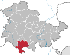
Distrito de Hildburghausen
distrito de Alemania
El distrito de Hildburghausen (en alemán: Landkreis Hildburghausen) es el Landkreis (distrito rural) más meridional del estado federal de Turingia (Alemania. Los distritos vecinos son la ciudad Suhl, al noroeste Ilm-Kreis, al este el distrito de Saalfeld-Rudolstadt, al oeste el distrito de Sonneberg, al sudoeste y sur los distritos de Coburgo, Haßberge y Rhön-Grabfeld.
| Distrito de Hildburghausen | ||||
|---|---|---|---|---|
| Entidad subnacional | ||||
| ||||
 | ||||
| Coordenadas | 50°25′N 10°45′E / 50.42, 10.75 | |||
| Capital | Hildburghausen | |||
| Entidad | Rural district of Thuringia | |||
| • País |
| |||
| Superficie | ||||
| • Total | 937 km² | |||
| Altitud | ||||
| • Media | 482 m s. n. m. | |||
| Población (2015) | ||||
| • Total | 64 524 hab. | |||
| • Densidad | 68,76 hab./km² | |||
| Huso horario | UTC+01:00 y UTC+02:00 | |||
| Matrícula | HBN | |||
| Sitio web oficial | ||||
Composición del distrito editar
(Habitantes a 30 de junio de 2006)
Ciudades editar
|
Municipios editar
|
Agrupaciones administrativas editar
|
Verwaltungsgemeinschaft Feldstein (5581)
Verwaltungssitz ist Themar, was selbst nicht zur VG Feldstein gehört. |
Verwaltungsgemeinschaft Gleichberge (4875)
Verwaltungsgemeinschaft Heldburger Unterland (5500)
|

