Archivo:Bowen Mexico or New Spain 1752 UTA.jpg
Tamaño de esta previsualización: 716 × 599 píxeles. Otras resoluciones: 287 × 240 píxeles · 574 × 480 píxeles · 918 × 768 píxeles · 1223 × 1024 píxeles · 2447 × 2048 píxeles · 2664 × 2230 píxeles.
Ver la imagen en su resolución original (2664 × 2230 píxeles; tamaño de archivo: 7,49 MB; tipo MIME: image/jpeg)
Resumen
| Título |
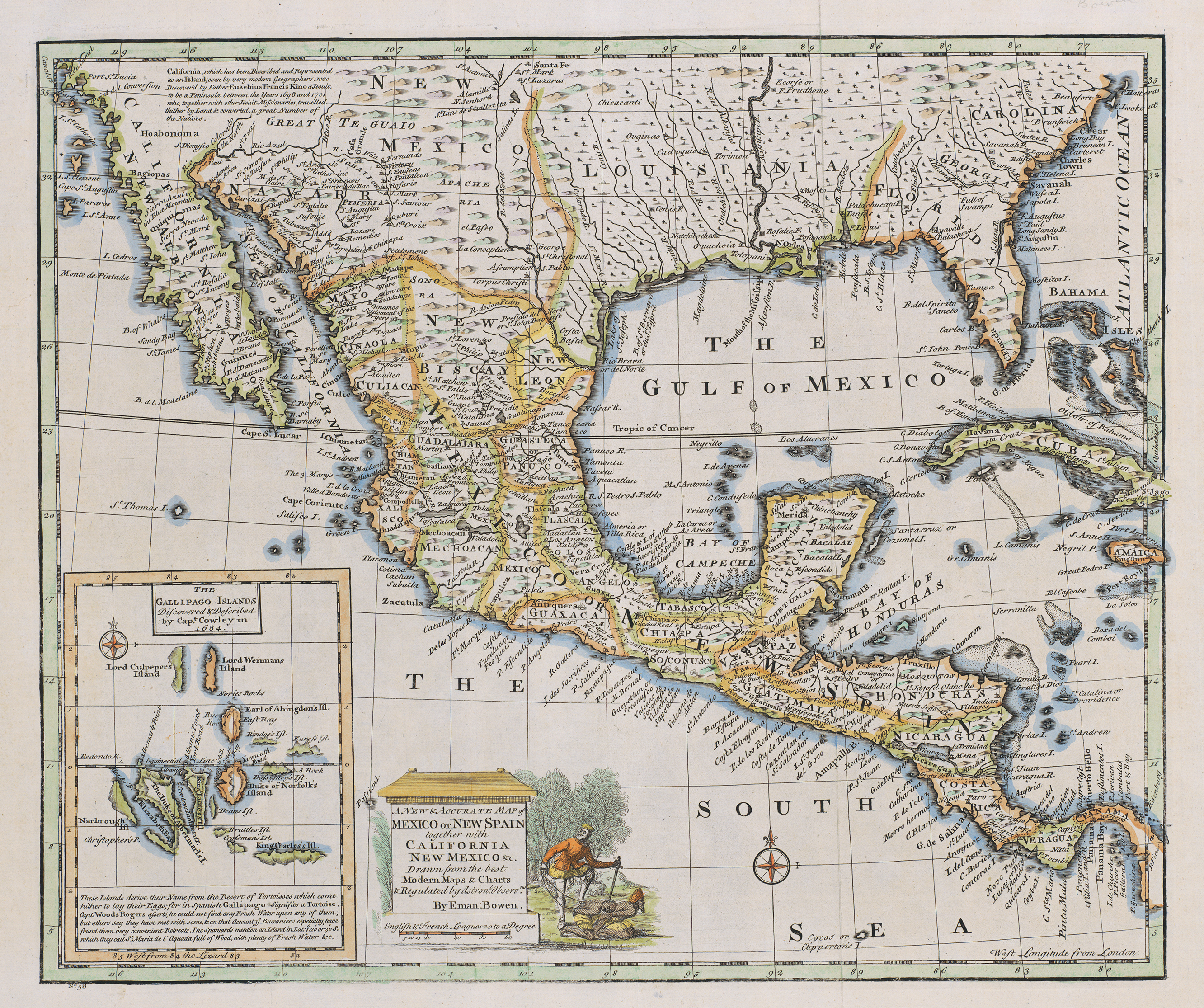
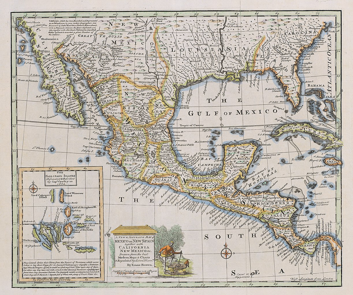
English: A New & Accurate Map of Mexico or New Spain together with California, New Mexico &c |
||||||||||||||||||||||||||
| Descripción |
English: The cartouche of this map of New Spain depicts a European mishandling a couple of Native American captives. The image dates at least back to 1729 when Peter Van der Aa included an identical image on his cartouche of a map of Mexico or New Spain appearing in Abraham du Bois' La Geographie Moderne, published in Leiden at that date. Such images, repeated over and over, contributed to the Spanish "Black Legend" – the idea that the Spanish treated Indians worse than their Anglo-Protestant peers, many of whom behaved equally bad in reality. Bowen's inset depicts the Galápagos Islands based upon descriptions and charts by English sea captains William A. Cowley and Woodes Rogers. Despite the "modern" scientific jargon with reference to "astronomical observations", English engraver, cartographer, publisher and print-seller Emanuel Bowen, even as Geographer to His Majesty, did not have access to accurate field information for much of the territories depicted – no one would until the mid-nineteenth century. His map shows Santa Fe along the 101st meridian instead of its actual location along the 105th, with the result that New Mexico lies four degrees of longitude east of its true location, and the area of present west Texas is considerably condensed. |
||||||||||||||||||||||||||
| Fecha | |||||||||||||||||||||||||||
| Fuente | UTA Libraries Cartographic Connections: mapa / texto | ||||||||||||||||||||||||||
| Creador |
|
||||||||||||||||||||||||||
| Adquisición |
English: The University of Texas at Arlington Libraries Special Collections, Gift of Virginia Garrett |
||||||||||||||||||||||||||
| Geotemporal data | |||||||||||||||||||||||||||
| Map location |
México Virreinato de Nueva España |
||||||||||||||||||||||||||
| Georeferencing | If inappropriate please set warp_status = skip to hide. | ||||||||||||||||||||||||||
| Bibliographic data | |||||||||||||||||||||||||||
| Autor |
|
||||||||||||||||||||||||||
| Lugar de publicación | Londres | ||||||||||||||||||||||||||
| Archival data | |||||||||||||||||||||||||||
| Colección |
|
||||||||||||||||||||||||||
| Dimensiones | altura: 36 cm; ancho: 43 cm | ||||||||||||||||||||||||||
| Técnica |
grabado coloreado sobre papel aguafuerte coloreado sobre papel |
||||||||||||||||||||||||||
| Inscripciones |
English: Drawn from the best Modern Maps & Charts & Regulated by Astronl. Observns. |
||||||||||||||||||||||||||
| artwork-references | Huseman, Ben W. (2016) Enlightenment Mapmakers and the Southwest Borderlands, Arlington: The University of Texas at Arlington Libraries, nº47 , p. 37 | ||||||||||||||||||||||||||

Licencia

|
This file was provided to Wikimedia Commons by the University of Texas at Arlington Libraries as part of a cooperation project. The University of Texas at Arlington Libraries is part of the University of Texas at Arlington, a public research university located in Arlington, Texas.
|
|
Este material está en dominio público en los demás países donde el derecho de autor se extiende por 100 años (o menos) tras la muerte del autor. Esta obra está en el dominio público en los Estados Unidos porque fue publicada (o registrada con la Oficina del Derecho de Autor de los E.E. U.U.) antes del 1 de enero de 1929. | |
| Esta obra ha sido identificada como libre de las restricciones conocidas en virtud del derecho de autor, incluyendo todos los derechos conexos. | |
Historial del archivo
Haz clic sobre una fecha y hora para ver el archivo tal como apareció en ese momento.
| Fecha y hora | Miniatura | Dimensiones | Usuario | Comentario | |
|---|---|---|---|---|---|
| actual | 21:25 3 jul 2019 | | 2664 × 2230 (7,49 MB) | Michael Barera | == {{int:filedesc}} == {{Map |title = ''A New & Accurate Map of Mexico or New Spain together with California, New Mexico &c'' |description = {{en|The cartouche of this map of New Spain depicts a European mishandling a couple of Native American captives. The image dates at least back to 1729 when Peter Van der Aa included an identical image on his cartouche of a map of Mexico or New Spain appearing in Abraham du Bois' ''La Geographie Moderne'', published in Leiden at that d... |
Usos del archivo
La siguiente página usa este archivo:
Uso global del archivo
Las wikis siguientes utilizan este archivo:
- Uso en de.wikipedia.org
- Uso en en.wikipedia.org
- Uso en fr.wikipedia.org
- Uso en hr.wikipedia.org
- Uso en la.wikipedia.org