Archivo:Carte Nouvelle du Duché de Mantoue.jpg

Ver la imagen en su resolución original(7783 × 6464 píxeles; tamaño de archivo: 16,68 MB; tipo MIME: image/jpeg)

Resumen

Descripción
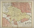
Deutsch: 1 Kt. : flächenkolor. (56 x 47 cm); Koordinaten E 10°07'00"-E 11°28'00"/N 45°25'00"-N 44°44'00"; Nachdruck. - Maßstab in graph. Form (Milles d'Italie, Lieües d'une heure de Chemin, Petites Lieües de France). - Titel oben. - Maßstabskartusche unten rechts. - Relief: Einzelberge plastisch
English: Map of the Duchy of Mantua designed by Guillaume Sanson (1633–1703), son of mapmaker Nicolas Sanson, and first published by Pieter Mortier in Amsterdam in 1703 (see map below). The map above is a 1760 reprint by the map publishing firm Covens & Mortier (which took over after Pieter Mortier's death). As is specified in the French-language title at the top, the map was issued for military purpose, specifically "for the use of the (French) armies in Italy" (during the War of the Spanish Succession presumably, given the 1703 publishing date); positions and roads used by the French and Imperial (Holy Roman Empire) armies are indicated.
Fecha hacia 1760
date QS:P,+1760-00-00T00:00:00Z/9,P1480,Q5727902
Fuente Leibniz-Institut für Länderkunde, Leipzig
Autor Sanson, Guillaume
Otras versiones

Militärkarte von Mantua mit Festungen, Lagern, Straßen etc. und Aufmarschkarte der Truppenteile

Licencia

Creative Commons CC-Zero Este archivo está disponible bajo la licencia Creative Commons Dedicación de Dominio Público CC0 1.0 Universal.
La persona que ha asociado una obra a este documento lo dedica al dominio público mediante la cesión mundial de sus derechos bajo la ley de derechos de autor y todos los derechos legales adyacentes propios de dicha, en el ámbito permitido por ley. Puedes copiar, modificar, distribuir y reproducir el trabajo, incluso con objetivos comerciales, sin pedir aprobación del autor.

Leyendas

Añade una explicación corta acerca de lo que representa este archivo

Elementos representados en este archivo

representa a

image/jpeg

5aec4461f44074f1c5e4b8f8e769f89a0b237841

17 489 366 byte

6464 píxel

7783 píxel

Historial del archivo

Haz clic sobre una fecha y hora para ver el archivo tal como apareció en ese momento.

Fecha y horaMiniaturaDimensionesUsuarioComentario
actual14:05 3 sep 2018Miniatura de la versión del 14:05 3 sep 20187783 × 6464 (16,68 MB)HiggenhorschtUser created page with UploadWizard

La siguiente página usa este archivo:

Uso global del archivo

Las wikis siguientes utilizan este archivo:

Metadatos