Archivo:Czechoslovakia I.png
Tamaño de esta previsualización: 800 × 364 píxeles. Otras resoluciones: 320 × 146 píxeles · 640 × 291 píxeles · 1128 × 513 píxeles.
Ver la imagen en su resolución original (1128 × 513 píxeles; tamaño de archivo: 66 kB; tipo MIME: image/png)
| Descripción |
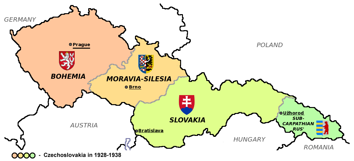
Čeština: Zemská mapa Československa v letech 1928 až 1938 s vyznačenými zemskými hlavními městy a znaky jednotlivých zemí English: Maps of Czechoslovakia in 1928-1938 with marked borders of all four Czechoslovak countries and their coats of arms and regional capital cities
Based on Image:Czechoslovakia_COA_medium.svg. * |
| Fecha | (UTC) |
| Fuente | |
| Autor | |
| Otras versiones |
Obras derivadas de ésta: |
| Esta es una imagen retocada, lo que significa que ha sido alterada digitalmente de su versión original. Modificaciones: Simplified map. La original se puede ver aquí: CarpathianRutheniaCoA.svg. Las modificaciones las hizo Millenium187.
|
Este archivo se encuentra bajo la licencia Creative Commons Genérica de Atribución/Compartir-Igual 3.0.
- Eres libre:
- de compartir – de copiar, distribuir y transmitir el trabajo
- de remezclar – de adaptar el trabajo
- Bajo las siguientes condiciones:
- atribución – Debes otorgar el crédito correspondiente, proporcionar un enlace a la licencia e indicar si realizaste algún cambio. Puedes hacerlo de cualquier manera razonable pero no de manera que sugiera que el licenciante te respalda a ti o al uso que hagas del trabajo.
- compartir igual – En caso de mezclar, transformar o modificar este trabajo, deberás distribuir el trabajo resultante bajo la misma licencia o una compatible como el original.
Registro original de carga
This image is a derivative work of the following images:
- File:Czechoslovakia01.png licensed with PD-self
- 2011-05-19T10:54:48Z PANONIAN 1128x513 (64020 Bytes) minor change, marked provincial capitals
- 2011-05-17T09:53:27Z PANONIAN 1128x513 (63994 Bytes) Reverted to version as of 10:38, 24 April 2011 - because this is map of Czechoslovakia and it was capital of Czechoslovakia
- 2011-05-17T05:07:38Z Millenium187 1128x513 (56086 Bytes) Why was Prague underlined and Vienna, Brno, Bratislava and other capital cities were not? -- corrected
- 2011-04-24T10:38:30Z PANONIAN 1128x513 (63994 Bytes) few corrections
- 2011-04-23T11:31:49Z PANONIAN 1128x509 (62348 Bytes) improved version
- 2008-12-20T20:58:14Z Kirk 1100x497 (80038 Bytes) {{Information |Description= |Source= |Date= |Author= |Permission= |other_versions= }}
- 2006-12-28T16:11:35Z Electionworld 1100x497 (92110 Bytes) {{ew|en|PANONIAN}} Map of {{link|Czechoslovakia}} (self made) Note: The provinces shown on the map were introduced by Act No. 125/1927 Zb. and became effective in 1928. {{PD-self}} [[Category:Maps of Czechoslovakia]] [[Cat
- File:Small_coat_of_arms_of_the_Czech_Republic2.png licensed with PD-self
- 2006-07-18T15:34:18Z Poznaniak 486x594 (126651 Bytes) {{Information |Description=Godło Czech |Source=własna praca |Date=18.07.2006 |Author=[[:user:Poznaniak|Poznaniak]] |Permission= }}
- File:Moravia-Silesia.png licensed with PD-self
- 2010-07-25T21:44:29Z RgC 490x600 (65918 Bytes) {{Information |Description={{en|1=Joint of coat of arms of Moravia and Silesia.}} |Source={{own}} |Author=[[User:RgC|RgC]] |Date=2010-07-25 |Permission= |other_versions= }} [[Category:User page images]]
- File:Coat_of_arms_of_Slovakia.svg licensed with Cc-by-sa-3.0-migrated, GFDL
- 2006-06-06T21:41:47Z Tlusťa 400x500 (4623 Bytes) ==Summary== {{Information |Description={{en|Coat of arms of the [[Slovakia]].}} {{cs|Znak [[:cs:Slovensko|Slovenska]].}} |Source= |Date= |Author=[[User:Tlusťa|Tlusťa]] |Permission= |other_versions= }} ==Licensing == {{GFDL
- File:CarpathianRutheniaCoA.svg licensed with Cc-pd-mark-footer, PD-old
- 2007-06-01T16:53:20Z DDima 325x394 (27235 Bytes) fix colors
- 2006-11-08T06:35:05Z Happenstance 325x394 (27214 Bytes) created
Uploaded with derivativeFX
| Annotations | This image is annotated: View the annotations at Commons |
Historial del archivo
Haz clic sobre una fecha y hora para ver el archivo tal como apareció en ese momento.
| Fecha y hora | Miniatura | Dimensiones | Usuario | Comentario | |
|---|---|---|---|---|---|
| actual | 18:40 12 ago 2011 | | 1128 × 513 (66 kB) | Millenium187 | {{Information |Description={{cs|Zemská mapa Československa v letech 1928 až 1938 s vyznačenými zemskými hlavními městy a znaky jednotlivých zemí}} {{en|Maps of Czechoslovakia in 1928-1938 with marked borders of all four Czechoslovak countries a |
Usos del archivo
La siguiente página usa este archivo:
Uso global del archivo
Las wikis siguientes utilizan este archivo:
- Uso en azb.wikipedia.org
- Uso en az.wikipedia.org
- Uso en bn.wikipedia.org
- Uso en da.wikipedia.org
- Uso en de.wikipedia.org
- Uso en el.wikipedia.org
- Uso en en.wikipedia.org
- Uso en he.wikipedia.org
- Uso en io.wikipedia.org
- Uso en mk.wikipedia.org
- Uso en sq.wikipedia.org
- Uso en te.wikipedia.org
- Uso en th.wikipedia.org
- Uso en tr.wikipedia.org
- Uso en uk.wikipedia.org