Archivo:ECOWAS map.png
No se dispone de una resolución más alta.
ECOWAS_map.png (360 × 392 píxeles; tamaño de archivo: 10 kB; tipo MIME: image/png)
| Descripción |
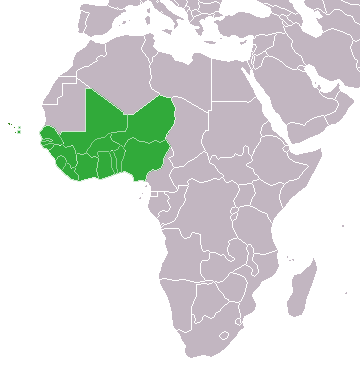
English: Map of African, with African Union member states in dark green and states with suspended membership in light green |
| Fecha | (UTC) |
| Fuente | |
| Autor |
The original uploader was Theunixgeek de Wikipedia en inglés.
|

|
File:ECOWAS members.svg es una versión vectorial de este archivo. Debería usarse esa versión en lugar de este archivo PNG, cuando sea mejor.
File:ECOWAS map.png → File:ECOWAS members.svg
Para más información, lee Ayuda:SVG. |
 |
Yo, el titular de los derechos de autor de esta obra, la publico en los términos de la siguiente licencia:
Este archivo se encuentra bajo la licencia Creative Commons Genérica de Atribución/Compartir-Igual 3.0.
- Eres libre:
- de compartir – de copiar, distribuir y transmitir el trabajo
- de remezclar – de adaptar el trabajo
- Bajo las siguientes condiciones:
- atribución – Debes otorgar el crédito correspondiente, proporcionar un enlace a la licencia e indicar si realizaste algún cambio. Puedes hacerlo de cualquier manera razonable pero no de manera que sugiera que el licenciante te respalda a ti o al uso que hagas del trabajo.
- compartir igual – En caso de mezclar, transformar o modificar este trabajo, deberás distribuir el trabajo resultante bajo la misma licencia o una compatible como el original.
Registro original de carga
This image is a derivative work of the following images:
- File:Map_of_the_African_Union_with_Suspended_States.svg licensed with Cc-by-sa-3.0
- 2010-03-29T19:33:05Z Roxanna 1000x1000 (128410 Bytes) Reverted to version as of 07:36, 19 February 2010
- 2010-03-29T19:25:59Z Roxanna 500x500 (50468 Bytes) ... but I think Mauritania is still suspended
- 2010-03-29T19:21:17Z Roxanna 500x500 (64647 Bytes) Officially Eritrea seems not yet to be outside of the AU...
- 2010-02-19T07:36:33Z Tomeasy 1000x1000 (128410 Bytes) Changed status of Eritrea from "suspended" to outside of the African Union due to withdrawal of this country.
- 2009-11-21T14:09:51Z Rotsee 1000x1000 (203340 Bytes) {{Information |Description={{en|Map of the African Union with Suspended States in Light Green}} |Source=Transferred from [http://en.wikipedia.org en.wikipedia] (Original text : ''Based on information in the [[:en:African Unio
Uploaded with derivativeFX
Historial del archivo
Haz clic sobre una fecha y hora para ver el archivo tal como apareció en ese momento.
| Fecha y hora | Miniatura | Dimensiones | Usuario | Comentario | |
|---|---|---|---|---|---|
| actual | 02:40 23 mar 2020 | | 360 × 392 (10 kB) | Uglemat | Morocco not a member |
| 16:56 22 oct 2017 |  | 360 × 392 (8 kB) | Casabus | + Morocco | |
| 02:21 27 oct 2012 |  | 360 × 392 (10 kB) | GeoMauri | Update | |
| 15:28 9 jul 2011 |  | 360 × 392 (14 kB) | Maphobbyist | Check | |
| 15:22 9 jul 2011 |  | 360 × 392 (15 kB) | Maphobbyist | South Sudan has become independent on July 9, 2011. Sudan and South Sudan are shown with the new international border between them. | |
| 02:55 31 ene 2011 |  | 360 × 392 (15 kB) | Scottbp | Guinea readmitted. | |
| 23:30 13 dic 2010 |  | 360 × 392 (10 kB) | Helmandsare | Removed Mauritania. | |
| 06:49 9 dic 2010 |  | 360 × 392 (10 kB) | Helmandsare | Reclassified Côte d'Ivoire as a suspended member. | |
| 22:58 15 oct 2010 |  | 360 × 392 (10 kB) | Helmandsare | {{Information |Description={{en|Map of African, with African Union member states in dark green and states with suspended membership in light green}} |Source=*File:Map_of_the_African_Union_with_Suspended_States.svg |Date=2010-10-15 22:57 (UTC) |Autho |
Usos del archivo
No hay páginas que enlacen a este archivo.
Uso global del archivo
Las wikis siguientes utilizan este archivo:
- Uso en de.wikipedia.org