Archivo:Eastern Frontier, Cape of Good Hope, ca 1835.png

Tamaño de esta previsualización: 684 × 600 píxeles. Otras resoluciones: 274 × 240 píxeles · 548 × 480 píxeles · 836 × 733 píxeles.
Ver la imagen en su resolución original (836 × 733 píxeles; tamaño de archivo: 279 kB; tipo MIME: image/png)
Resumen
| Descripción |
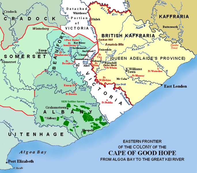
(i.e. period between 5th and 8th Xhosa Wars) 1820 British settler farms in the Albany district, or eastern Zuurveld
Settled colonial area (est. 1795), showing Grahamstown (est. 1812), and districts (est. 1820) in shades of pale green
Neutral zone (est. 1820), as agreed between Lord Charles Somerset and the Gaika (Ngqika) faction of the amaXhosa.
British Kaffraria (est. 1835), incl. East London (est. 1847): Gaika faction of amaXhosa and amaTembu under British protection.
Kaffraria, incl. Butterworth Wesleyan mission (est. 1827): amaTembu living inland and amaXhosa nearer the coast.
Mountains and necks, incl. Gaika's Hill 32°32′46″S 26°57′07″E / 32.54611°S 26.95194°E in the easternmost Winterberg.
Military forts, district boundaries and eastern frontier.
Notes
|
| Fecha | Redrawn and coloured in December 2007 |
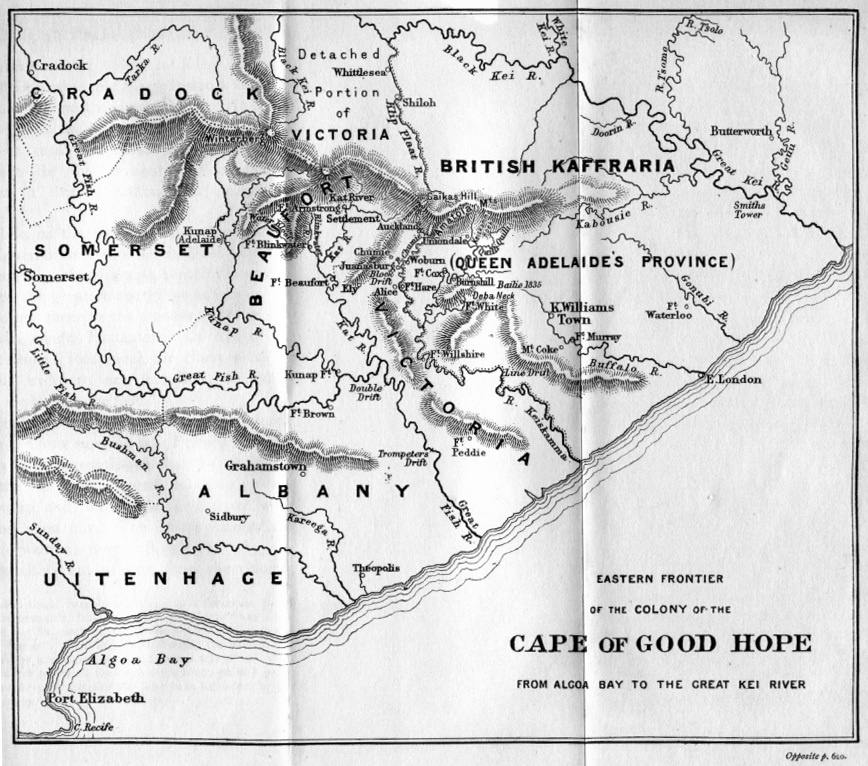
| Fuente | Based on the source map below, last published in 1903. |
| Autor | I created the map, based partly on the source map: Eastern frontier of the Colony of the Cape of Good Hope from Algoa Bay to the Great Kei river, which appears opposite page 620 of ‘The autobiography of Lieutenant-general Sir Harry Smith’ by G.C.B. Bart, Chapter xlviii, published 1903, as part of the online Build a Book initiative. JMK 11:03, 26 December 2007 (UTC) |
| Otras versiones |
The original map relates to 1850 more or less, and may be John Arrowsmith's 1851 Eastern Frontier of the Colony of the Cape of Good Hope (and part of Kafirland), From Algoa Bay to the Great Kei River. Arrowsmith's lithograph was redrawn and compiled chiefly from M.S. Surveys & Sketches, communicated by Lt. Col. Mitchell late Survr. Genl. of the Colony and Captn. Wm Owen ...: _(14761876926).jpg) Compare also Arrowsmith, 1836:  |

Licencia
Yo, titular de los derechos de autor de esta obra, la publico en los términos de las siguientes licencias:

|
Se autoriza la copia, distribución y modificación de este documento bajo los términos de la licencia de documentación libre GNU, versión 1.2 o cualquier otra que posteriormente publique la Fundación para el Software Libre; sin secciones invariables, textos de portada, ni textos de contraportada. Se incluye una copia de la dicha licencia en la sección titulada Licencia de Documentación Libre GNU. |
This file is licensed under the Creative Commons Attribution-Share Alike 4.0 International, 3.0 Unported, 2.5 Generic, 2.0 Generic and 1.0 Generic license.
- Eres libre:
- de compartir – de copiar, distribuir y transmitir el trabajo
- de remezclar – de adaptar el trabajo
- Bajo las siguientes condiciones:
- atribución – Debes otorgar el crédito correspondiente, proporcionar un enlace a la licencia e indicar si realizaste algún cambio. Puedes hacerlo de cualquier manera razonable pero no de manera que sugiera que el licenciante te respalda a ti o al uso que hagas del trabajo.
- compartir igual – En caso de mezclar, transformar o modificar este trabajo, deberás distribuir el trabajo resultante bajo la misma licencia o una compatible como el original.
Puedes usar la licencia que prefieras.
Historial del archivo
Haz clic sobre una fecha y hora para ver el archivo tal como apareció en ese momento.
| Fecha y hora | Miniatura | Dimensiones | Usuario | Comentario | |
|---|---|---|---|---|---|
| actual | 00:57 13 ene 2021 | | 836 × 733 (279 kB) | JMK | add label |
| 11:41 13 may 2019 |  | 836 × 733 (278 kB) | JMK | Change map colour east of Great Kei River (based on comments received), as it was never part of British Caffraria. Other minor changes. | |
| 11:47 30 dic 2007 |  | 836 × 733 (253 kB) | JMK | Update | |
| 10:58 26 dic 2007 |  | 836 × 733 (257 kB) | JMK | {{Information |Description=Eastern frontier of the Colony of the Cape of Good Hope from Algoa Bay to the Great Kei river *Settled colonial area shown in green, with districts established in 1820 shown in different shades of green *Neutral zone agreed on b | |
| 10:55 26 dic 2007 |  | 836 × 733 (257 kB) | JMK | {{Information |Description=Eastern frontier of the Colony of the Cape of Good Hope from Algoa Bay to the Great Kei river *Settled colonial area shown in green, with districts established in 1820 shown in different shades of green *Neutral zone agreed on b |
Usos del archivo
Las siguientes páginas usan este archivo:
Uso global del archivo
Las wikis siguientes utilizan este archivo:
- Uso en af.wikipedia.org
- Uso en ca.wikipedia.org
- Uso en de.wikipedia.org
- Uso en en.wikipedia.org
- Uso en eo.wikipedia.org
- Uso en fa.wikipedia.org
- Uso en fr.wikipedia.org
- Uso en he.wikipedia.org
- Uso en it.wikipedia.org
- Uso en ja.wikipedia.org
- Uso en mk.wikipedia.org
- Uso en nl.wikipedia.org
- Uso en ru.wikipedia.org
- Uso en sv.wikipedia.org
- Uso en uk.wikipedia.org
- Uso en www.wikidata.org
- Uso en xh.wikipedia.org