Archivo:European microstates map.svg

Tamaño de esta previsualización PNG del archivo SVG: 553 × 600 píxeles. Otras resoluciones: 221 × 240 píxeles · 442 × 480 píxeles · 708 × 768 píxeles · 944 × 1024 píxeles · 1888 × 2048 píxeles.
Ver la imagen en su resolución original ((Imagen SVG, nominalmente 553 × 600 pixels, tamaño de archivo: 1,18 MB))
Resumen
| Descripción |
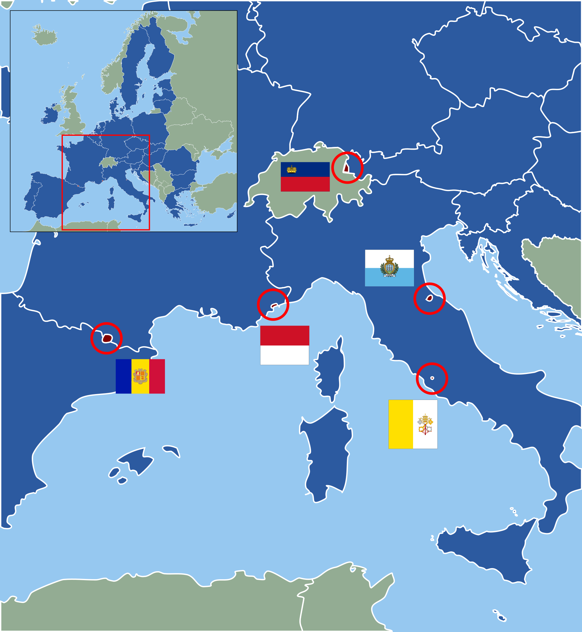
Deutsch: Karte der europäischen Zwergstaaten und der Europäischen Union (2013). Staaten der EU sind blau, Zuordnung der Mikrostaaten nach ihren Flaggen wie folgt:
English: Map of European Microstates and the European Union in 2013. The European Union is in blue, microstate flags as follows:
|
| Fecha | (UTC) |
| Fuente | |
| Autor |
|
| Esta es una imagen retocada, lo que significa que ha sido alterada digitalmente de su versión original. Modificaciones: Vectorization under usage of blank svg map. La original se puede ver aquí: European Microstates Map.png. Las modificaciones las hizo Master Uegly.
|
Licencia
Este archivo se encuentra bajo la licencia Creative Commons Genérica de Atribución/Compartir-Igual 3.0.
- Eres libre:
- de compartir – de copiar, distribuir y transmitir el trabajo
- de remezclar – de adaptar el trabajo
- Bajo las siguientes condiciones:
- atribución – Debes otorgar el crédito correspondiente, proporcionar un enlace a la licencia e indicar si realizaste algún cambio. Puedes hacerlo de cualquier manera razonable pero no de manera que sugiera que el licenciante te respalda a ti o al uso que hagas del trabajo.
- compartir igual – En caso de mezclar, transformar o modificar este trabajo, deberás distribuir el trabajo resultante bajo la misma licencia o una compatible como el original.
Registro original de carga
This image is a derivative work of the following images:
- File:Blank_map_of_Europe.svg licensed with Cc-by-sa-2.5
- 2011-09-19T22:57:58Z Alphathon 680x520 (603759 Bytes) Added North/Northern Cyprus
- 2011-08-23T10:26:48Z Heb 680x520 (604212 Bytes) Added [[:en:Bornholm]] (taken from [[:File:Denmark blank map.svg]])
- 2011-04-12T00:40:40Z Alphathon 680x520 (602549 Bytes) Upgraded Sicily based on "File:Freeworldmaps-sicily.jpg". Upgraded Malta based on "File:Map of Malta 2.png". Simplified Croatian borders.
- 2011-04-10T21:43:04Z Alphathon 680x520 (607359 Bytes) Upgraded Croatia, Bosnia & Herzegovina, Slovenia and surrounding countries based on data from "File:Kroatien - Politische Gliederung (Karte).png"
- 2011-04-10T20:05:09Z Alphathon 680x520 (568373 Bytes) Improved Serbia, Montenegro and surrounding countries using data from "File:Serbia Map.png". Fixed Serbia-Montenegro border. Added Kosovo (using dashed border, since it is not a universally recognised nation, and left the lan
- 2011-04-10T15:55:02Z Alphathon 680x520 (524980 Bytes) Tweaked Ukraine and surrounding countries based on data from "File:Up-map.png"
- 2011-04-10T04:02:09Z Alphathon 680x520 (511168 Bytes) Improved Greece, Albania, F.Y.R. Macedonia and Bulgaria based on "File:Greece topo.jpg"
- 2011-04-10T02:48:52Z Alphathon 680x520 (505569 Bytes) Tweaked Germany and surrounding countries based on info from "File:Germany_general_map.png"
- 2011-04-10T01:54:05Z Alphathon 680x520 (493733 Bytes) Converted all lakes back to separate layer. Added Finish lakes and tweaked Finland shape based on "File:Finland 1996 CIA map.jpg". Added Swiss lakes based on "File:Suisse cantons.svg". Tweaked Scotland and added Lochs.
- 2011-04-10T00:07:54Z Alphathon 680x520 (450120 Bytes) Improved England outline and added Isle of Wight based on "File:England Regions - Blank.svg". Improved Denmark based on "File:2 digit postcode danmark.png". Improved Sweden based on "File:Map of Sweden, CIA, 1996.jpg"
- 2011-04-08T15:53:07Z Alphathon 680x520 (438878 Bytes) Upgraded/fixed various parts of the map. Details: *Some minor fixes to Ireland and added some of the larger lakes based on [[:File:Ireland_trad_counties_named.svg]] *Pretty major fixes to Scotland (mainly the west coast and i
- (10 more entrys follow)
- File:European_Microstates_Map.png licensed with PD-self
- 2007-06-20T12:16:46Z JLogan 212x217 (8731 Bytes) {{Information |Description=Map of European Microstates |Source=self-made |Date=12 March 2007 |Author= [[User:JLogan|JLogan]] }}
Uploaded with derivativeFX
Historial del archivo
Haz clic sobre una fecha y hora para ver el archivo tal como apareció en ese momento.
| Fecha y hora | Miniatura | Dimensiones | Usuario | Comentario | |
|---|---|---|---|---|---|
| actual | 13:04 27 feb 2022 | | 553 × 600 (1,18 MB) | Welkend | own mistake corrected (Iceland) |
| 12:58 27 feb 2022 |  | 553 × 600 (1,17 MB) | Welkend | own mistake corrected (red circle around Monaco) | |
| 12:56 27 feb 2022 |  | 553 × 600 (1,17 MB) | Welkend | little cosmetic corrections of the borders of the map and the shape of Monaco | |
| 11:41 2 feb 2020 |  | 553 × 600 (1,17 MB) | NordNordWest | upd | |
| 11:40 30 jun 2013 |  | 553 × 600 (1,17 MB) | NordNordWest | upd | |
| 23:59 9 dic 2011 |  | 553 × 600 (1,17 MB) | Master Uegly | == {{int:filedesc}} == {{Information |Description={{de|Karte der europäischen Zwergstaaten und der Europäischen Union (2010). Staaten der EU sind blau, Zuordnung der Mikrostaaten nach ihren Flaggen wie folgt:}} {{en|Map of European Microstates and the E |
Usos del archivo
Las siguientes páginas usan este archivo:
Uso global del archivo
Las wikis siguientes utilizan este archivo:
- Uso en az.wikipedia.org
- Uso en cs.wikipedia.org
- Uso en de.wikipedia.org
- Uso en fa.wikipedia.org
- Uso en fi.wikipedia.org
- Uso en fr.wikipedia.org
- Uso en hr.wikipedia.org
- Uso en hy.wikipedia.org
- Uso en lb.wikipedia.org
- Uso en pl.wikipedia.org
- Uso en pt.wikipedia.org
- Uso en ru.wikipedia.org
- Uso en sv.wikipedia.org
- Uso en th.wikipedia.org
- Uso en uk.wikipedia.org
- Uso en www.wikidata.org
- Uso en zh.wikipedia.org