Archivo:Fay 2014 track.png

Tamaño de esta previsualización: 800 × 495 píxeles. Otras resoluciones: 320 × 198 píxeles · 640 × 396 píxeles · 1024 × 633 píxeles · 1280 × 791 píxeles · 2700 × 1669 píxeles.
Ver la imagen en su resolución original (2700 × 1669 píxeles; tamaño de archivo: 1,02 MB; tipo MIME: image/png)
Resumen
| Descripción |
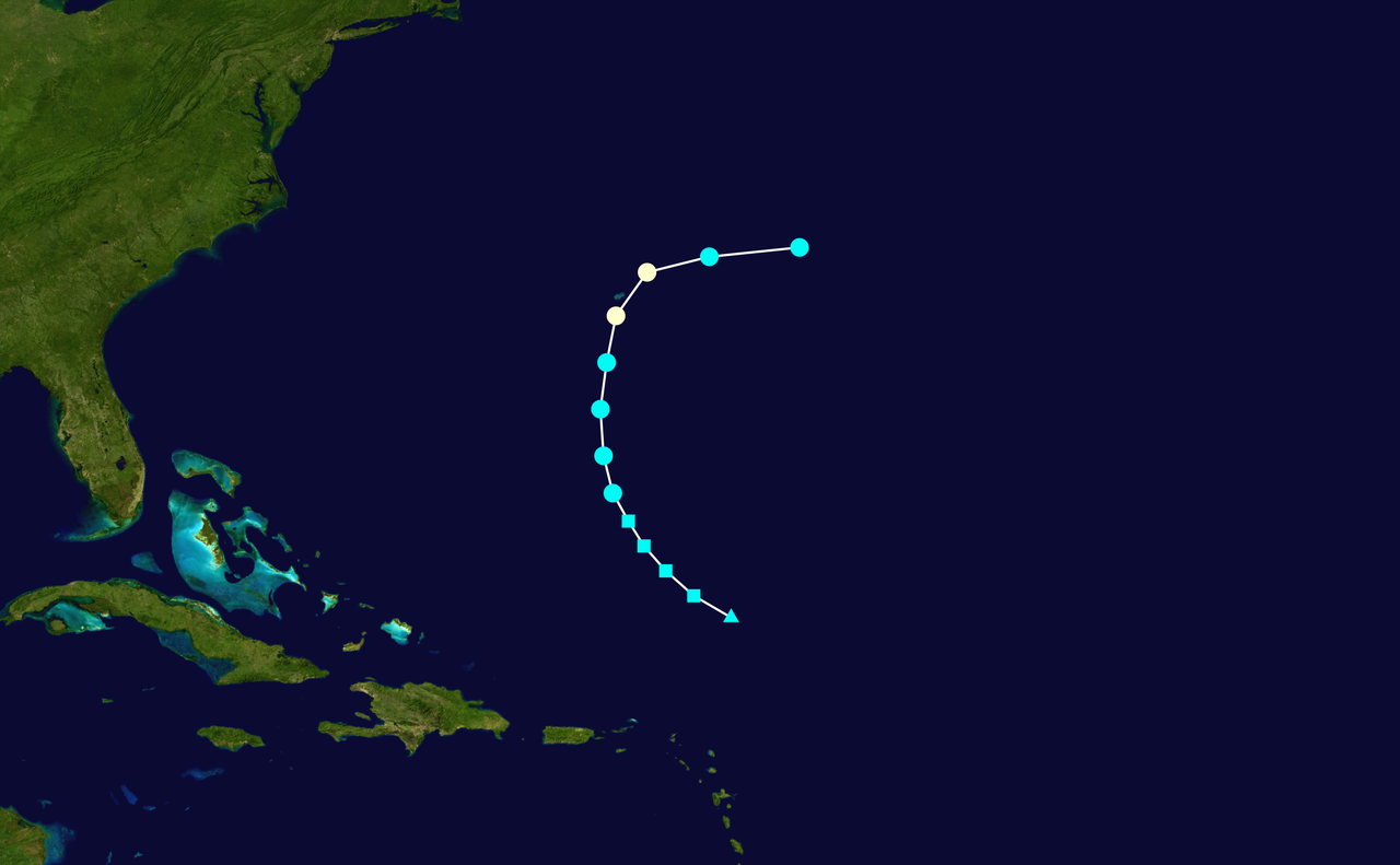
English: Track map of Hurricane Fay of the 2014 Atlantic hurricane season. The points show the location of the storm at 6-hour intervals. The colour represents the storm's maximum sustained wind speeds as classified in the (see below), and the shape of the data points represent the nature of the storm, according to the legend below. Tropical depression (≤38 mph, ≤62 km/h)
Tropical storm (39–73 mph, 63–118 km/h)
Category 1 (74–95 mph, 119–153 km/h)
Category 2 (96–110 mph, 154–177 km/h)
Category 3 (111–129 mph, 178–208 km/h)
Category 4 (130–156 mph, 209–251 km/h)
Category 5 (≥157 mph, ≥252 km/h)
Unknown
Storm type |
||
| Fecha | 2014-10-10–2014-10-13 | ||
| Fuente | Created by Cyclonebiskit using Wikipedia:WikiProject Tropical cyclones/Tracks. The background image is from NASA. Tracking data is from the National Hurricane Center[1]. | ||
| Autor | Cyclonebiskit | ||
| Source code | Track map data table, if present below, is in HURDAT2 or ATCF format. See format details in [2] and [3], respectively.
|
Licencia
| Este trabajo ha sido liberado al dominio público por su autor, Cyclonebiskit. Esto aplica para todo el mundo. En algunos países esto puede no ser legalmente factible; si ello ocurriese: Cyclonebiskit otorga a cualquier persona el derecho de usar este trabajo para cualquier propósito, sin ningún tipo de condición, a menos que éstas sean requeridas por la ley. |
Historial del archivo
Haz clic sobre una fecha y hora para ver el archivo tal como apareció en ese momento.
| Fecha y hora | Miniatura | Dimensiones | Usuario | Comentario | |
|---|---|---|---|---|---|
| actual | 21:44 16 dic 2014 | | 2700 × 1669 (1,02 MB) | Supportstorm | Best track update |
| 21:20 13 oct 2014 |  | 2000 × 1236 (331 kB) | Cyclonebiskit | {{WPTC track map | author = Cyclonebiskit | name = Hurricane Fay | article = Hurricane Fay (2014) | season = 2014 Atlantic hurricane season | start = 2014-10-08 | end = 2014-10-13 | othersource=Tracking data from the {{w|National Hurricane Cente... |
Usos del archivo
Las siguientes páginas usan este archivo:
Uso global del archivo
Las wikis siguientes utilizan este archivo:
- Uso en de.wikipedia.org
- Uso en fr.wikipedia.org
- Uso en ko.wikipedia.org
- Uso en pt.wikipedia.org
- Uso en zh.wikipedia.org