Archivo:Great Bitter Lake, Egypt.jpg

Tamaño de esta previsualización: 800 × 533 píxeles. Otras resoluciones: 320 × 213 píxeles · 640 × 427 píxeles · 1024 × 683 píxeles · 1440 × 960 píxeles.
Ver la imagen en su resolución original (1440 × 960 píxeles; tamaño de archivo: 323 kB; tipo MIME: image/jpeg)
Resumen
| Descripción |
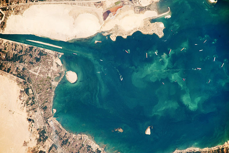
English: Several ships, some under power and some anchored, are visible at image right. Large expanses of white and tan sandy sediments at image left and top attest to the desert conditions surrounding the lake. Located at the approximate midpoint of the Suez Canal, Great Bitter Lake is now filled with water derived from both the Red and Mediterranean Seas, and this steady influx of water balances the water lost to evaporation. The town of Fayid (also spelled as Fayed), visible along the western shore of the lake (bottom) is a tourist destination for residents of Cairo, particularly in the summer months.
|
||||||||||||||||||||||||||||||||||||||||||||||||||
| Fecha | |||||||||||||||||||||||||||||||||||||||||||||||||||
| Fuente | NASA Earth Observatory | ||||||||||||||||||||||||||||||||||||||||||||||||||
| Autor | This image was taken by the NASA Expedition 20 crew. | ||||||||||||||||||||||||||||||||||||||||||||||||||
This photograph was acquired with a Nikon D3 digital camera fitted with an 800 mm lens, and is provided by the ISS Crew Earth Observations experiment and Image Science & Analysis Laboratory, Johnson Space Centre.
Licencia
| Este archivo es de dominio público porque fue creado por la NASA. Las políticas sobre copyright de la NASA estipulan que «el material de la NASA no está protegido con copyright a menos que se indique lo contrario». (Políticas sobre copyright de la NASA o Políticas sobre la utilización de imágenes del Jet Propulsion Laboratory). | ||
 |
Advertencias:
|
Historial del archivo
Haz clic sobre una fecha y hora para ver el archivo tal como apareció en ese momento.
| Fecha y hora | Miniatura | Dimensiones | Usuario | Comentario | |
|---|---|---|---|---|---|
| actual | 15:23 26 oct 2009 | | 1440 × 960 (323 kB) | Originalwana | {{Information |Description={{en|1=Several ships, some under power and some anchored, are visible at image right. Large expanses of white and tan sandy sediments at image left and top attest to the desert cond |
Usos del archivo
La siguiente página usa este archivo:
Uso global del archivo
Las wikis siguientes utilizan este archivo:
- Uso en af.wikipedia.org
- Uso en ar.wikipedia.org
- Uso en arz.wikipedia.org
- Uso en ca.wikipedia.org
- Uso en en.wikipedia.org
- Uso en eo.wikipedia.org
- Uso en eu.wikipedia.org
- Uso en fi.wikipedia.org
- Uso en he.wikipedia.org
- Uso en id.wikipedia.org
- Uso en kk.wikipedia.org
- Uso en la.wikipedia.org
- Uso en mt.wikipedia.org
- Uso en my.wikipedia.org
- Uso en pl.wikipedia.org
- Uso en pt.wikipedia.org
- Uso en simple.wikipedia.org
- Uso en tr.wikipedia.org
- Uso en zh.wikipedia.org