Archivo:Haitian Port Damage1.jpg
Tamaño de esta previsualización: 800 × 534 píxeles. Otras resoluciones: 320 × 213 píxeles · 640 × 427 píxeles · 1018 × 679 píxeles.
Ver la imagen en su resolución original (1018 × 679 píxeles; tamaño de archivo: 123 kB; tipo MIME: image/jpeg)
Resumen
| Descripción |
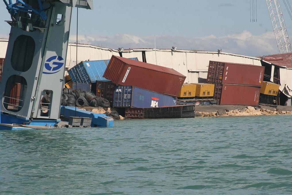
English: PORT-AU-PRINCE, Haiti – "Coast Guard crewmembers photographed tumbling shipping containers at Port-au-Prince Jan. 13, 2010. Coast Guard personnel arrived in Haiti to assess damage to the ports and waterways after an earthquake ravaged the island Jan. 12, 2010. U.S. Coast Guard photo." (Text From U.S. Coast Guard) |
| Fecha | |
| Fuente | U.S. Coast Guard, 100113-G-9999G-050-Damaged Haiti Ports |
| Autor | U.S. Coast Guard photo |
| Posición de la cámara | | Ubicación de esta y otras imágenes en: OpenStreetMap |
|---|
Licencia
This image or file is a work of a United States Coast Guard service personnel or employee, taken or made as part of that person's official duties. As a work of the U.S. federal government, the image or file is in the public domain (17 U.S.C. § 101 and § 105, USCG main privacy policy and specific privacy policy for its imagery server).
|
 |
Historial del archivo
Haz clic sobre una fecha y hora para ver el archivo tal como apareció en ese momento.
| Fecha y hora | Miniatura | Dimensiones | Usuario | Comentario | |
|---|---|---|---|---|---|
| actual | 02:25 14 ene 2010 | | 1018 × 679 (123 kB) | Marcusmax | {{Information |Description={{en|1=PORT-AU-PRINCE, Haiti -- "Coast Guard crewmembers photographed tumbling shipping containers at Port-au-Prince Jan. 13, 2010. Coast Guard personnel arrived in Haiti to assess damage to the ports and waterways after an eart |
Usos del archivo
La siguiente página usa este archivo:
Uso global del archivo
Las wikis siguientes utilizan este archivo:
- Uso en ast.wikipedia.org
- Uso en de.wikipedia.org
- Uso en en.wikinews.org
- Uso en eo.wikipedia.org
- Uso en fi.wikipedia.org
- Uso en fr.wikipedia.org
- Uso en hr.wikipedia.org
- Uso en ja.wikipedia.org
- Uso en ms.wikipedia.org
- Uso en pl.wikipedia.org
- Uso en ru.wikipedia.org
- Uso en sh.wikipedia.org
- Uso en szl.wikipedia.org
- Uso en tr.wikipedia.org
- Uso en uk.wikipedia.org
- Uso en www.wikidata.org