Archivo:ISS021-E-15710 Pearl Harbor, Hawaii.jpg

Ver la imagen en su resolución original (4288 × 2848 píxeles; tamaño de archivo: 11,07 MB; tipo MIME: image/jpeg)
Resumen
| Descripción |
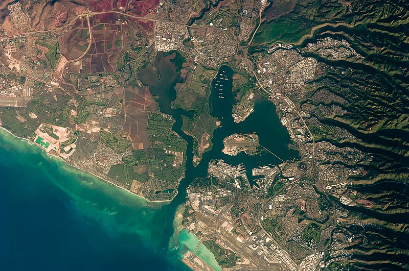
English: This detailed astronaut photograph illustrates the southern coastline of the Hawaiian island Oahu, including Pearl Harbor. On December 7, 1941—68 years ago—a surprise attack by the Japanese Navy on Pearl Harbor and other targets on the island of Oahu precipitated the entry of the United States into World War II. Today, Pearl Harbor is still in use as a major United States Navy installation, and along with Honolulu, it is one of the most heavily developed parts of the island.
A comparison between this image and a 2003 astronaut photograph of Pearl Harbor suggests that little observable land use or land cover change has occurred in the area over the past six years. The most significant difference is the presence of more naval vessels in the Reserve Fleet anchorage in Middle Loch (image center). The urban areas of Waipahu, Pearl City, and Aliamanu border the harbor to the northwest, north, and east. The built-up areas, recognizable by linear streets and white rooftops, contrast sharply with the reddish volcanic soils and green vegetation on the surrounding hills.
|
||||||||||||||||||||||||||||||||||||||||||||||||||
| Fecha | |||||||||||||||||||||||||||||||||||||||||||||||||||
| Fuente | http://eol.jsc.nasa.gov/scripts/sseop/photo.pl?mission=ISS021&roll=E&frame=15710 | ||||||||||||||||||||||||||||||||||||||||||||||||||
| Autor |
|
||||||||||||||||||||||||||||||||||||||||||||||||||
| Otras versiones |
|
||||||||||||||||||||||||||||||||||||||||||||||||||

| Posición de la cámara | | Ubicación de esta y otras imágenes en: OpenStreetMap |
|---|
| Ubicación del objeto | | Ubicación de esta y otras imágenes en: OpenStreetMap |
|---|
Este archivo fue catalogado por Johnson Space Center de la Administración Nacional de Aeronáutica y del Espacio (NASA) de los Estados Unidos de Américabajo el identificador de foto: ISS021-E-15710.Esta etiqueta no indica el estado de los derechos de autor del trabajo adjunto. Se requiere una etiqueta de derechos de autor normal. Para más información vea Commons:Sobre las licencias. Otros idiomas:
|
Licencia
| Este archivo es de dominio público porque fue creado por la NASA. Las políticas sobre copyright de la NASA estipulan que «el material de la NASA no está protegido con copyright a menos que se indique lo contrario». (Políticas sobre copyright de la NASA o Políticas sobre la utilización de imágenes del Jet Propulsion Laboratory). | ||
 |
Advertencias:
|
| Annotations | This image is annotated: View the annotations at Commons |
Historial del archivo
Haz clic sobre una fecha y hora para ver el archivo tal como apareció en ese momento.
| Fecha y hora | Miniatura | Dimensiones | Usuario | Comentario | |
|---|---|---|---|---|---|
| actual | 17:34 22 mar 2013 | | 4288 × 2848 (11,07 MB) | Julian Herzog | User created page with UploadWizard |
Usos del archivo
Las siguientes páginas usan este archivo:
Uso global del archivo
Las wikis siguientes utilizan este archivo:
- Uso en bn.wikipedia.org
- Uso en ca.wikipedia.org
- Uso en de.wikipedia.org
- Uso en en.wikipedia.org
- Uso en en.wikiversity.org
- Uso en fr.wikipedia.org
- Uso en fy.wikipedia.org
- Uso en gn.wikipedia.org
- Uso en oc.wikipedia.org
- Uso en pt.wikipedia.org
- Uso en zh.wikipedia.org