Archivo:Lewis and Clark Middle Missouri BigSioux James.jpg

Ver la imagen en su resolución original (1160 × 1050 píxeles; tamaño de archivo: 1,21 MB; tipo MIME: image/jpeg)
| Descripción |
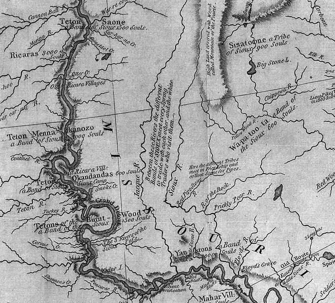
English: This is an excerpt of the Lewis and Clark's. This excerpt shows the rivers in eastern and central South Dakota and northwestern Iowa. The most notable river (left and bottom) is the en:Missouri River. Also shown are the en:Big Sioux River (Sioux River) and en:James River (Jacque R.).
Author: Lewis, Meriwether ; Clark, William ; Biddle, Nicholas ; Allen, Paul http://en.wikipedia.org/wiki/Image:Map_of_Lewis_and_Clark%27s_Track%2C_Across_the_Western_Portion_of_North_America%2C_published_1814.jpg Date: 1814 Short Title: Map of Lewis and Clark's Track, Across the Western Portion of North America. Publisher: Philadelphia: Bradford and Inskeep Type: Book Map Obj Height cm: 30 Obj Width cm: 70 Scale 1: 4,300,000 Note: Uncolored map showing topography and rivers in the region as well as towns, Indian villages, and population figures. Bound into the front of volume one. Reference: Howes L317; Sabin 40828; WC 13; Wheat 316. State/Province: U.S. West Full Title: A Map of Lewis and Clark's Track, Across the Western Portion of North America From the Mississippi to the Pacific Ocean; By Order of the Executive of the United States, in 1804, 5 & 6. Copied by Samuel Lewis from the Original Drawing of Wm. Clark. Smal. Harrison fct. List No: 3493.001 Series No: 2 Engraver or Printer: Lewis, Samuel ; Harrison, Samuel, 1789-1818 Publication Author: Lewis, Meriwether ; Clark, William ; Biddle, Nicholas ; Allen, Paul Pub Date: 1814 Pub Title: History Of The Expedition Under The Command Of Captains Lewis And Clark, To The Sources Of The Missouri, Thence Across The Rocky Mountains And Down The River Columbia To The Pacific Ocean. Performed During The Years 1804-5-6. By order of the Government Of The United States. Prepared For The Press By Paul Allen, Esquire. In Two Volumes. Vol. I. Philadelphia: Published By Bradford And Inskeep, New York. J. Maxwell, Printer. 1814 ... Vol. II. Pub Reference: Howes L317; Sabin 40828; WC 13; Wheat 316. Pub Note: 1st edition. Notwithstanding the title, Nicholas Biddle completed the text after Lewis's suicide. The map and the written account of the expedition changed American mapping of the northwest by giving the first accurate depiction of the relationship of the sources of the Missouri, the sources of the Columbia, and the Rocky Mountains. The map was copied by Samuel Lewis from William Clark's original drawing, and was engraved by Samuel Harrison. The title of the map is "A Map of Lewis and Clark's Track, Across the Western Portion of North America From the Mississippi to the Pacific Ocean ..." Maps are without color. In 2 volumes newly bound in full leather with the title "Lewis & Clark's Expedition ..." stamped in gilt on the spine. Pub List No: 3493.000 Pub Type: Exploration Book Pub Maps: 6 Pub Height cm: 23 Pub Width cm: 14 |
| Fecha | |
| Fuente | see above |
| Autor | Lewis, Meriwether ; Clark, William ; Biddle, Nicholas ; Allen, Paul |
Licencia
|
Este material está en dominio público en los demás países donde el derecho de autor se extiende por 70 años (o menos) tras la muerte del autor.
| |
| Esta obra ha sido identificada como libre de las restricciones conocidas en virtud del derecho de autor, incluyendo todos los derechos conexos. | |
Registro original de carga
- 2008-02-27 03:00 Jerry picker 1160×1050× (1268253 bytes) This is an excerpt of the Lewis and Clark map posted to Wikipedia commons. This excerpt shows the rivers in northwestern Iowa and eastern South Dakota. Of particular note are the [[Big Sioux River]] (Sioux River) and [[James River]] (Rive Jacques). Autho
Historial del archivo
Haz clic sobre una fecha y hora para ver el archivo tal como apareció en ese momento.
| Fecha y hora | Miniatura | Dimensiones | Usuario | Comentario | |
|---|---|---|---|---|---|
| actual | 12:43 19 dic 2008 | | 1160 × 1050 (1,21 MB) | Urdangaray | {{Information |Description={{en|This is an excerpt of the Lewis and Clark map posted to Wikipedia commons. This excerpt shows the rivers in northwestern Iowa and eastern South Dakota. Of particular note are the en:Big Sioux River (Sioux River) and [[ |
Usos del archivo
Las siguientes páginas usan este archivo:
Uso global del archivo
Las wikis siguientes utilizan este archivo:
- Uso en ar.wikipedia.org
- Uso en bn.wikipedia.org
- Uso en de.wikipedia.org
- Uso en en.wikipedia.org
- Uso en fr.wikipedia.org
- Uso en ro.wikipedia.org