Archivo:Mindanao1900 Distributionoftheraces.jpg

Tamaño de esta previsualización: 528 × 599 píxeles. Otras resoluciones: 211 × 240 píxeles · 423 × 480 píxeles · 810 × 919 píxeles.
Ver la imagen en su resolución original (810 × 919 píxeles; tamaño de archivo: 186 kB; tipo MIME: image/jpeg)
Historial del archivo
Haz clic sobre una fecha y hora para ver el archivo tal como apareció en ese momento.
| Fecha y hora | Miniatura | Dimensiones | Usuario | Comentario | |
|---|---|---|---|---|---|
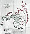
| actual | 12:33 18 sep 2012 |  | 810 × 919 (186 kB) | Prince of Sulbod | {{Information |Description ={{en|1=The map of MIndanao, from the Annual Report of US War Department for 1900, which is one of the earliest maps of Mindanao drawn by the Americans. It shows the distribution of races and tribes of Mindanao in their tr... |
Usos del archivo
La siguiente página usa este archivo:
Uso global del archivo
Las wikis siguientes utilizan este archivo: