Archivo:Puerto de Veracruz Desastre Huracan Karl 2010.png

Tamaño de esta previsualización: 468 × 599 píxeles. Otras resoluciones: 187 × 240 píxeles · 631 × 808 píxeles.
Ver la imagen en su resolución original (631 × 808 píxeles; tamaño de archivo: 323 kB; tipo MIME: image/png)
Resumen
| Descripción |
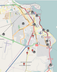
English: Map of the Veracruz City (Puerto de Veracruz) due to the Hurricane Karl Disaster in September 2010. Drastical floods took place with several parts of the City and other Regions several damaged. Hundreds of people were affected.
Mark descriptions: Red mark, Incidents reported; Black houses, Warehouses; Camping tents, Shelters; Blue dots, multiple. The information in the map is not completed. Many particulars and organization as well as the government of the State of Veracruz make efforts and support facilities, nevertheless anyone is to be known to have a complete report of such information. The information was taken from the local media, mainly internet web pages of local newspapers and radio station "XEU de Veracruz". The information is detailed in the referenced website (source). |
| Fecha | |
| Fuente | Veracruz Disaster Site from Sahanafoundation |
| Autor | Gengiskanhg |
| Posición de la cámara | | Ubicación de esta y otras imágenes en: OpenStreetMap |
|---|
Licencia
Este archivo se encuentra bajo la licencia Creative Commons Atribución 3.0 Unported.
- Eres libre:
- de compartir – de copiar, distribuir y transmitir el trabajo
- de remezclar – de adaptar el trabajo
- Bajo las siguientes condiciones:
- atribución – Debes otorgar el crédito correspondiente, proporcionar un enlace a la licencia e indicar si realizaste algún cambio. Puedes hacerlo de cualquier manera razonable pero no de manera que sugiera que el licenciante te respalda a ti o al uso que hagas del trabajo.
Historial del archivo
Haz clic sobre una fecha y hora para ver el archivo tal como apareció en ese momento.
| Fecha y hora | Miniatura | Dimensiones | Usuario | Comentario | |
|---|---|---|---|---|---|
| actual | 21:07 2 nov 2010 | | 631 × 808 (323 kB) | Gengiskanhg | Using OpenStreetMaps instead of google in order to avoid possible license problems. |
| 20:52 2 nov 2010 |  | 665 × 829 (431 kB) | Gengiskanhg | {{Information |Description={{en|1=Map of the Veracruz City (Puerto de Veracruz) due to the Huricane Karl Disaster in September 2010. Drastical floods took place with several parts of the City and other Regions several damaged. Hundreds of people were affe |
Usos del archivo
La siguiente página usa este archivo: