Archivo:Relief Map of New Siberian Islands.png
No se dispone de una resolución más alta.
Relief_Map_of_New_Siberian_Islands.png (675 × 546 píxeles; tamaño de archivo: 304 kB; tipo MIME: image/png)
Resumen
| Descripción |
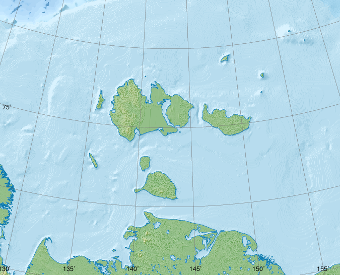
Русский: Новосибирские острова, физическая карта.
|
| Fecha | |
| Fuente |
|
| Autor | Nzeemin |
| Otras versiones |
|

Licencia
Yo, el titular de los derechos de autor de esta obra, la publico en los términos de la siguiente licencia:
Este archivo se encuentra bajo la licencia Creative Commons Genérica de Atribución/Compartir-Igual 3.0.
- Eres libre:
- de compartir – de copiar, distribuir y transmitir el trabajo
- de remezclar – de adaptar el trabajo
- Bajo las siguientes condiciones:
- atribución – Debes otorgar el crédito correspondiente, proporcionar un enlace a la licencia e indicar si realizaste algún cambio. Puedes hacerlo de cualquier manera razonable pero no de manera que sugiera que el licenciante te respalda a ti o al uso que hagas del trabajo.
- compartir igual – En caso de mezclar, transformar o modificar este trabajo, deberás distribuir el trabajo resultante bajo la misma licencia o una compatible como el original.
Source Code
set PATH=C:\programs\GMT5\bin;%PATH%
set GSBIN=C:\PROGRA~1\gs\gs9.04/bin

set COORDS=129.8/70.8/163.2/77.5
rem width = xmaxsvg / 150.0 * 2.54
set PAPERX=11.43
rem height = ymaxsvg / 150.0 * 2.54
set PAPERY=9.25
set PROJNCOORDS=-JA143/74.5/4.5i -R%COORDS%r

grdraster 34 -R122/164/70/79 -Gh.grd
grdgradient h.grd -Ne0.3 -A315 -M -Ghi.grd
if not errorlevel 0 goto End

pscoast.exe %PROJNCOORDS% -Gc -Df -P --PAPER_MEDIA=Custom_%PAPERX%cx%PAPERY%c -X0 -Y0 -K > map.eps
grdimage h.grd -Ihi.grd -Cmount.cpt -P %PROJNCOORDS% --PAPER_MEDIA=Custom_%PAPERX%cx%PAPERY%c -X0 -Y0 -O -K >> map.eps
if not errorlevel 0 goto End
pscoast.exe %PROJNCOORDS% -Q -Df -P --PAPER_MEDIA=Custom_%PAPERX%cx%PAPERY%c -X0 -Y0 -O -K >> map.eps

rem grdimage h_cor_cut.grd -Ihi.grd -Cwiki-water-verlauf2.cpt -P %COORDSCUT% --PAPER_MEDIA=Custom_%PAPERX%cx%PAPERY%c -X0 -Y0 -K -O >> map.eps
if not errorlevel 0 goto End

grdcut.exe ETOPO1_Bed_g_gmt4.grd -R122/164/70/79 -Gh_cor_cut.grd
grdgradient h_cor_cut.grd -Ne0.3 -A315 -M -Ghi.grd
if not errorlevel 0 goto End

pscoast %PROJNCOORDS% -Sc -Df -P --PAPER_MEDIA=Custom_%PAPERX%cx%PAPERY%c -X0 -Y0 -O -K >> map.eps
if not errorlevel 0 goto End
grdimage h_cor_cut.grd -Ihi.grd -Cwiki-water-verlauf2.cpt -P %PROJNCOORDS% --PAPER_MEDIA=Custom_%PAPERX%cx%PAPERY%c -X0 -Y0 -K -O >> map.eps
if not errorlevel 0 goto End
rem grdcontour h_cor_cut.grd -C250 -Wc0.2p,#0978AB -P %PROJNCOORDS% --PAPER_MEDIA=Custom_%PAPERX%cx%PAPERY%c -X0 -Y0 -K -O >> map.eps
if not errorlevel 0 goto End
pscoast %PROJNCOORDS% -Q -Df -P --PAPER_MEDIA=Custom_%PAPERX%cx%PAPERY%c -X0 -Y0 -O -K >> map.eps
if not errorlevel 0 goto End

pscoast.exe %PROJNCOORDS% -W0.25,#0978AB -Df -P --PAPER_MEDIA=Custom_%PAPERX%cx%PAPERY%c -X0 -Y0 -O -K >> map.eps

psbasemap %PROJNCOORDS% -Ba5S --PLOT_DEGREE_FORMAT=ddd:mm --ANNOT_FONT_SIZE_PRIMARY=6p -P --MAP_ANNOT_OFFSET_PRIMARY=0 --PAPER_MEDIA=Custom_%PAPERX%cx%PAPERY%c --OBLIQUE_ANNOTATION=6 --BASEMAP_FRAME_RGB=+9/120/171 --FRAME_PEN=0p,0_100:0p --TICK_PEN=0p,0_100:0p --TICK_LENGTH=-0.3c -X0 -Y0 -O -K >> map.eps
if not errorlevel 0 goto End
psbasemap %PROJNCOORDS% -Ba5W --PLOT_DEGREE_FORMAT=ddd:mm --ANNOT_FONT_SIZE_PRIMARY=6p -P --MAP_ANNOT_OFFSET_PRIMARY=0 --PAPER_MEDIA=Custom_%PAPERX%cx%PAPERY%c --OBLIQUE_ANNOTATION=6 --BASEMAP_FRAME_RGB=+9/120/171 --FRAME_PEN=0p,0_100:0p --TICK_PEN=0p,0_100:0p --TICK_LENGTH=-0.4c -X0 -Y0 -O -K >> map.eps
if not errorlevel 0 goto End

gmtset GRID_PEN_PRIMARY = 0.08p,#606060
psbasemap %PROJNCOORDS% -Bg5/g2+1 --FRAME_PEN=0p,0_100:0p -P --PAPER_MEDIA=Custom_%PAPERX%cx%PAPERY%c -X0 -Y0 -O >> map.eps
if not errorlevel 0 goto End

%GSBIN%\gswin32c.exe -dSAFER -dBATCH -dNOPAUSE -dGraphicsAlphaBits=4 -sDEVICE=pngalpha -dEPSCrop -r150 -sOutputFile=Oblast_phys_1.png map.eps
if not errorlevel 0 goto End

del h.grd
del hi.grd

:End
Historial del archivo
Haz clic sobre una fecha y hora para ver el archivo tal como apareció en ese momento.
| Fecha y hora | Miniatura | Dimensiones | Usuario | Comentario | |
|---|---|---|---|---|---|
| actual | 19:11 31 may 2015 | | 675 × 546 (304 kB) | Cmdrjameson | Compressed with pngout. Reduced by 142kB (31% decrease). |
| 08:34 7 abr 2012 |  | 675 × 546 (447 kB) | Nzeemin | frame removed | |
| 19:42 4 abr 2012 |  | 675 × 546 (444 kB) | Nzeemin |
Usos del archivo
La siguiente página usa este archivo:
Uso global del archivo
Las wikis siguientes utilizan este archivo:
- Uso en az.wikipedia.org
- Uso en ba.wikipedia.org
- Uso en be.wikipedia.org
- Uso en ceb.wikipedia.org
- Uso en de.wikipedia.org
- Uso en et.wikipedia.org
- Uso en fr.wikipedia.org
- Uso en he.wikipedia.org
- Uso en hr.wikipedia.org
- Uso en ja.wikipedia.org
- Uso en os.wikipedia.org
- Uso en pl.wikipedia.org
- Uso en ru.wikipedia.org
- Земля Санникова
- Острова Анжу
- Котельный
- Острова Де-Лонга
- Новая Сибирь
- Большой Ляховский
- Пролив Дмитрия Лаптева
- Пролив Санникова
- Остров Генриетты
- Остров Жаннетты
- Фаддеевский
- Столбовой (остров)
- Малакатын-Тас
- Бельковский
- Остров Беннетта
- Земля Бунге
- Остров Жохова
- Остров Вилькицкого (Восточно-Сибирское море)
- Малый Ляховский
Ver más uso global de este archivo.