Archivo:San Juan, Metro Manila (2344411253).jpg

Tamaño de esta previsualización: 800 × 523 píxeles. Otras resoluciones: 320 × 209 píxeles · 640 × 418 píxeles · 1024 × 670 píxeles · 1280 × 837 píxeles · 2768 × 1810 píxeles.
Ver la imagen en su resolución original (2768 × 1810 píxeles; tamaño de archivo: 1,11 MB; tipo MIME: image/jpeg)
.jpg?uselang=es)
Resumen
| Descripción |
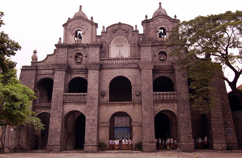
The Dominicans built the first parochial buildings in 1602 that were razed during the 1639 Chinese revolt. These were rebuilt in 1641, burned down during the British invasion of 1763, and rebuilt again in 1774. Nikon D40 (INAFI Board of Trustees' Meeting, February 2008). |
| Fecha | |
| Fuente | San Juan, Metro Manila |
| Autor | Shubert Ciencia from Nueva Ecija, Philippines |
| Posición de la cámara | | Ubicación de esta y otras imágenes en: OpenStreetMap |
|---|
.jpg¶ms=014.598534_N_0120.991058_E_globe:Earth_type:camera_source:Flickr_&language=es)
Licencia
- Objeto
The depicted Philippine architecture, 3D public art, or other freedom of panorama (FoP)-reliant work is in public domain because:
See Commons:Copyright rules by territory/Philippines#Public domain exceptions for FoP-reliant works for more information. Images of copyrighted architecture and public art are normally not allowed on Wikimedia Commons, unless there is an applicable freedom of panorama (FoP) in the works' country of origin. However, there is no such exception in Republic Act No. 8293 (The Intellectual Property Code of the Philippines), see Commons:Copyright rules by territory/Philippines#Freedom of panorama for more information.
|
 |
- Foto
Este archivo está disponible bajo la licencia Creative Commons Atribución 2.0 Genérica.
- Eres libre:
- de compartir – de copiar, distribuir y transmitir el trabajo
- de remezclar – de adaptar el trabajo
- Bajo las siguientes condiciones:
- atribución – Debes otorgar el crédito correspondiente, proporcionar un enlace a la licencia e indicar si realizaste algún cambio. Puedes hacerlo de cualquier manera razonable pero no de manera que sugiera que el licenciante te respalda a ti o al uso que hagas del trabajo.
| Esta imagen, originalmente subida a Flickr, fue revisada el July 6, 2008 por el administrador o revisor File Upload Bot (Magnus Manske), quien comprobó que el archivo se encontraba disponible en Flickr bajo la licencia nombrada en dicha fecha. |
Historial del archivo
Haz clic sobre una fecha y hora para ver el archivo tal como apareció en ese momento.
| Fecha y hora | Miniatura | Dimensiones | Usuario | Comentario | |
|---|---|---|---|---|---|
| actual | 18:03 6 jul 2008 | | 2768 × 1810 (1,11 MB) | File Upload Bot (Magnus Manske) | {{Information |Description= The Dominicans built the first parochial buildings in 1602 that were razed during the 1639 Chinese revolt. These were rebuilt in 1641, burned down during the British invasion of 1763, and rebuilt again in 1774. The city of San |
Usos del archivo
La siguiente página usa este archivo:
Uso global del archivo
Las wikis siguientes utilizan este archivo:
- Uso en bcl.wikipedia.org
- Uso en en.wikipedia.org
- Uso en eo.wikipedia.org
- Uso en incubator.wikimedia.org
- Uso en sl.wikipedia.org
- Uso en zh.wikipedia.org
.jpg)