Archivo:Trafalgar 1200hr.svg

Tamaño de esta previsualización PNG del archivo SVG: 606 × 599 píxeles. Otras resoluciones: 243 × 240 píxeles · 485 × 480 píxeles · 776 × 768 píxeles · 1035 × 1024 píxeles · 2070 × 2048 píxeles · 743 × 735 píxeles.
Ver la imagen en su resolución original ((Imagen SVG, nominalmente 743 × 735 pixels, tamaño de archivo: 77 kB))
Resumen
| Descripción |
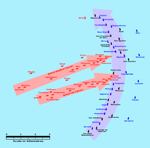
English: This map of the Battle of Trafalgar shows the approximate position of the two fleets at 1200 hours during the battle as the Royal Sovereign was breaking into the Franco-Spanish line. North is to the top, and Cape Trafalgar is 10 miles to the northeast. |
| Fecha | |
| Fuente | own work made with Inkscape from Image:Trafalgar 1200hr.gif : This drawing is based on an illustration in issue number 84 of the Strategy & Tactics magazine The map was made by RJHall using the Campaign Cartographer drawing program, and the image was reduced in size 50% in Paint Shop Pro. Ship icons are not to scale. |
| Autor | Pinpin |
Licencia
Yo, titular de los derechos de autor de esta obra, la publico en los términos de las siguientes licencias:

|
Se autoriza la copia, distribución y modificación de este documento bajo los términos de la licencia de documentación libre GNU, versión 1.2 o cualquier otra que posteriormente publique la Fundación para el Software Libre; sin secciones invariables, textos de portada, ni textos de contraportada. Se incluye una copia de la dicha licencia en la sección titulada Licencia de Documentación Libre GNU. |
Este archivo se encuentra bajo la licencia Creative Commons Attribution-Share Alike 3.0 Unported, 2.5 Generic, 2.0 Generic and 1.0 Generic
- Eres libre:
- de compartir – de copiar, distribuir y transmitir el trabajo
- de remezclar – de adaptar el trabajo
- Bajo las siguientes condiciones:
- atribución – Debes otorgar el crédito correspondiente, proporcionar un enlace a la licencia e indicar si realizaste algún cambio. Puedes hacerlo de cualquier manera razonable pero no de manera que sugiera que el licenciante te respalda a ti o al uso que hagas del trabajo.
- compartir igual – En caso de mezclar, transformar o modificar este trabajo, deberás distribuir el trabajo resultante bajo la misma licencia o una compatible como el original.
Puedes usar la licencia que prefieras.
Historial del archivo
Haz clic sobre una fecha y hora para ver el archivo tal como apareció en ese momento.
| Fecha y hora | Miniatura | Dimensiones | Usuario | Comentario | |
|---|---|---|---|---|---|
| actual | 03:45 29 ene 2008 | | 743 × 735 (77 kB) | Uhanu | I forgot the colour of Belleisle. |
| 03:43 29 ene 2008 |  | 743 × 735 (77 kB) | Uhanu | Correcting some names: Montañés , San Ildefonso, Agamemnon, Duguay-Trouin... and colour of Belleisle. | |
| 18:55 14 dic 2007 |  | 743 × 735 (77 kB) | Rama | Original SVG version at Image:Trafalgar 1200hr.gif * '''Description:''' This map of the '''Battle of Trafalgar''' shows the approximate position of the two fleets at 1200 hours during the battle as the Royal Sovereign was breaking into the Franc | |
| 20:11 3 oct 2007 |  | 900 × 850 (73 kB) | Pinpin | I forget one boat | |
| 20:04 3 oct 2007 |  | 900 × 850 (72 kB) | Pinpin | {{Information |Description={{en|This map of the '''Battle of Trafalgar''' shows the approximate position of the two fleets at 1200 hours during the battle as the Royal Sovereign was breaking into the Franco-Spanish line. North is to the top, and Cape |
Usos del archivo
Las siguientes páginas usan este archivo:
Uso global del archivo
Las wikis siguientes utilizan este archivo:
- Uso en azb.wikipedia.org
- Uso en bg.wikipedia.org
- Uso en ca.wikipedia.org
- Uso en de.wikipedia.org
- Uso en el.wikipedia.org
- Uso en en.wikipedia.org
- Uso en et.wikipedia.org
- Uso en fi.wikipedia.org
- Uso en he.wikipedia.org
- Uso en hu.wikipedia.org
- Uso en io.wikipedia.org
- Uso en it.wikipedia.org
- Uso en ja.wikipedia.org
- Uso en nl.wikipedia.org
- Uso en no.wikipedia.org
- Uso en ro.wikipedia.org
- Uso en ru.wikipedia.org
- Uso en sr.wikipedia.org
- Uso en sv.wikipedia.org
- Uso en th.wikipedia.org
- Uso en vi.wikipedia.org
- Uso en www.wikidata.org