Archivo:Vredefort.jpg

Tamaño de esta previsualización: 800 × 600 píxeles. Otras resoluciones: 320 × 240 píxeles · 640 × 480 píxeles · 1024 × 768 píxeles.
Ver la imagen en su resolución original (1024 × 768 píxeles; tamaño de archivo: 266 kB; tipo MIME: image/jpeg)
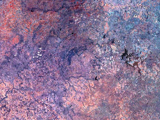
| Descripción | Vredefort crater has a diameter of 300 km, and its circular structure nearly fills the complete image. The Vredefort dome, a conspicuous geologic feature about 50 km in diameter, stands out at the center. |
| Fuente | Created with NASA WorldWind by User:Vesta using Landsat 7 (Visible Color) satellite image. |
| Autor | User:Vesta |
27°0′0″S 27°30′0″E / 27°S 27.5°E
| Esta imagen se encuentra en el dominio público porque es una captura de pantalla del software de globo terráqueo de la NASA, World Wind, que utiliza una capa de dominio público, como Blue Marble, MODIS, Landsat, SRTM, USGS o GLOBE.
|
 |
Historial del archivo
Haz clic sobre una fecha y hora para ver el archivo tal como apareció en ese momento.
| Fecha y hora | Miniatura | Dimensiones | Usuario | Comentario | |
|---|---|---|---|---|---|
| actual | 09:12 7 ene 2006 | | 1024 × 768 (266 kB) | Vesta~commonswiki | * '''Description:''' Vredefort crater has a diameter of 300 km, and its circular structure nearly fills the complete image. The Vredefort ring, a conspicuous feature, 50 km in diameter, stands out at the center. *'''Source:''' Created with NASA WorldWind |
Usos del archivo
La siguiente página usa este archivo:
Uso global del archivo
Las wikis siguientes utilizan este archivo:
- Uso en avk.wikipedia.org
- Uso en be.wikipedia.org
- Uso en de.wikipedia.org
- Uso en de.wikivoyage.org
- Uso en hr.wikipedia.org
- Uso en hy.wikipedia.org
- Uso en it.wikipedia.org
- Uso en lt.wikipedia.org
- Uso en ml.wikipedia.org
- Uso en pt.wikipedia.org
- Uso en ru.wikipedia.org
- Uso en sh.wikipedia.org
- Uso en sv.wikipedia.org