Archivo:2023 Netherlands States-Provincial election map.svg

Tamaño de esta previsualización PNG del archivo SVG: 774 × 600 píxeles. Otras resoluciones: 310 × 240 píxeles · 620 × 480 píxeles · 992 × 768 píxeles · 1280 × 992 píxeles · 2560 × 1983 píxeles · 1815 × 1406 píxeles.
Ver la imagen en su resolución original ((Imagen SVG, nominalmente 1815 × 1406 pixels, tamaño de archivo: 2,67 MB))
Resumen
| Descripción |
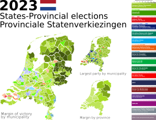
English: This is a map of the results of the 2023 Dutch provincial elections. The data was sourced from [1]
Notes on joint lists: For the GL-PvdA joint list in Zeeland, this map uses PvdA colors. For the CU-SGP joint list in North Brabant, this map uses CU colors. In the provinces where parties did not run on a joint list, this map takes the margin of the two against each other. For example, in a municipality where GL came first, PvdA came second, and BBB came third, the map takes the margin of GL from PvdA, not GL+PvdA against BBB. |
| Fecha | |
| Fuente | Trabajo propio |
| Autor | Windfarmer1799 |
Licencia
Yo, el titular de los derechos de autor de esta obra, la publico en los términos de la siguiente licencia:
Este archivo está disponible bajo la licencia Creative Commons Attribution-Share Alike 4.0 International.
- Eres libre:
- de compartir – de copiar, distribuir y transmitir el trabajo
- de remezclar – de adaptar el trabajo
- Bajo las siguientes condiciones:
- atribución – Debes otorgar el crédito correspondiente, proporcionar un enlace a la licencia e indicar si realizaste algún cambio. Puedes hacerlo de cualquier manera razonable pero no de manera que sugiera que el licenciante te respalda a ti o al uso que hagas del trabajo.
- compartir igual – En caso de mezclar, transformar o modificar este trabajo, deberás distribuir el trabajo resultante bajo la misma licencia o una compatible como el original.
Historial del archivo
Haz clic sobre una fecha y hora para ver el archivo tal como apareció en ese momento.
| Fecha y hora | Miniatura | Dimensiones | Usuario | Comentario | |
|---|---|---|---|---|---|
| actual | 17:23 14 oct 2023 | | 1815 × 1406 (2,67 MB) | Windfarmer1799 | removing seat counts and percentages as redundant and out of date |
| 02:06 20 mar 2023 |  | 2282 × 1406 (3,11 MB) | Windfarmer1799 | All text converted to paths. The map with true text can be found in the previous revision of this file. | |
| 02:05 20 mar 2023 |  | 2282 × 1406 (2,17 MB) | Windfarmer1799 | Update to reflect newly counted votes in North Holland. | |
| 18:09 19 mar 2023 |  | 2282 × 1406 (3,11 MB) | Windfarmer1799 | All text converted to paths. The map with embedded text can be found in the previous revision of this file. | |
| 18:07 19 mar 2023 |  | 2282 × 1406 (2,17 MB) | Windfarmer1799 | Uploaded own work with UploadWizard |
Usos del archivo
La siguiente página usa este archivo:
Uso global del archivo
Las wikis siguientes utilizan este archivo:
- Uso en en.wikipedia.org
- Uso en www.wikidata.org