Archivo:Abandoning the Arctic Exploration Ship Jeanette, by James Gale Tyler.jpg
Ver la imagen en su resolución original (852 × 581 píxeles; tamaño de archivo: 148 kB; tipo MIME: image/jpeg)
Resumen
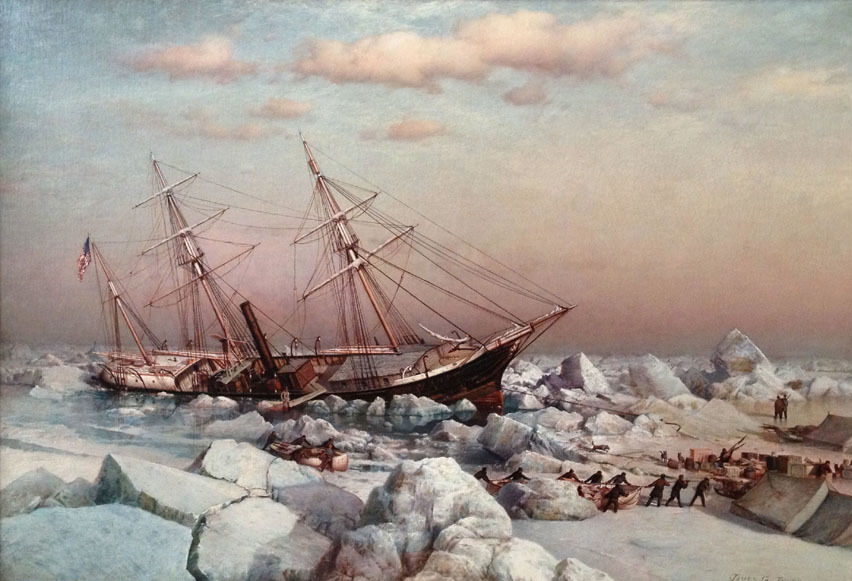
| James Gale Tyler: Abandoning the Arctic Exploration Ship Jeanette on June 12th 1891
|
||||||||||||||||||
|---|---|---|---|---|---|---|---|---|---|---|---|---|---|---|---|---|---|---|
| Artista |
|
 | ||||||||||||||||
| Título |
Abandoning the Arctic Exploration Ship Jeanette on June 12th 1891 |
|||||||||||||||||
| Object type | pintura | |||||||||||||||||
| Descripción |
English: Abandoning the Arctic Exploration Ship Jeanette on June 12th 1891, by James Gale Tyler. A time-line of the expedition illustrates the enormity of the challenge the men faced. Publisher James Gordon Bennett, Jr. purchased the ship, previously the HMS Pandora, and allied with the U.S. Government to fund the expedition. The Jeanette left San Francisco on July 8, 1879 and was held fast in ice east of Wrangell Island by September. The ship drifted northwest in the ice for the rest of 1879, all of 1880 and landed at an island they named Henrietta Island, in honor of Bennett, on May 9, 1881. This was more than 600 miles from where they first became stuck. While trapped, the men led by Lieut. Commander George W. DeLong, Assistant Surgeon James Ambler, Lieut. Charles Chipp and Chief Engineer George W. Melville battled hunger and fierce atmospheric conditions, all while conducting their scientific assignments, hunting, and maintaining their ship. |
|||||||||||||||||
| Fecha | 1883 | |||||||||||||||||
| Historial de la pieza | India House, New York | |||||||||||||||||
| Fuente/fotógrafo | Vallejo Gallery | |||||||||||||||||
| Posición de la cámara | | Ubicación de esta y otras imágenes en: OpenStreetMap |
|---|
Licencia
|
Esta es una reproducción fotográfica fiel de una obra de arte bidimensional de dominio público. La obra de arte misma se halla en el dominio público por el motivo siguiente:
La postura oficial de la Fundación Wikimedia considera que «las reproducciones fieles de obras de arte bidimensionales de dominio público forman parte del dominio público».
Esta reproducción fotográfica, por ende, también se considera de dominio público dentro de los Estados Unidos. Es posible que otras jurisdicciones restrinjan la reutilización de este contenido; consúltese Reutilización de fotografías PD-Art (en inglés) para más detalles. | ||||
Historial del archivo
Haz clic sobre una fecha y hora para ver el archivo tal como apareció en ese momento.
| Fecha y hora | Miniatura | Dimensiones | Usuario | Comentario | |
|---|---|---|---|---|---|
| actual | 18:26 21 may 2019 | | 852 × 581 (148 kB) | Broichmore | Cropped 1 % horizontally, 3 % vertically using CropTool with precise mode. |
| 18:24 21 may 2019 |  | 864 × 599 (133 kB) | Broichmore | User created page with UploadWizard |
Usos del archivo
La siguiente página usa este archivo:
Uso global del archivo
Las wikis siguientes utilizan este archivo:
- Uso en ca.wikipedia.org
- Uso en cs.wikipedia.org
- Uso en en.wikipedia.org
- Uso en ja.wikipedia.org
- Uso en lv.wikipedia.org
- Uso en ru.wikipedia.org
- Uso en www.wikidata.org