Archivo:Boone-06own-map.jpg
Tamaño de esta previsualización: 470 × 600 píxeles. Otras resoluciones: 188 × 240 píxeles · 580 × 740 píxeles.
Ver la imagen en su resolución original (580 × 740 píxeles; tamaño de archivo: 241 kB; tipo MIME: image/jpeg)
Resumen
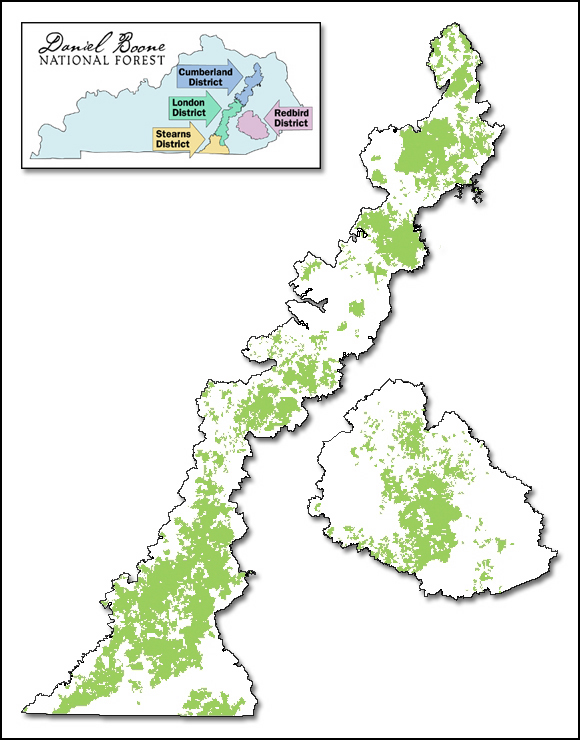
| Descripción |
English: Map of Daniel Boone National Forest showing proclamation boundary and lands actually owned by the Forest Service, as of March 15, 2006. Inset map shows ranger districts. |
| Fecha | |
| Fuente | http://www.fs.usda.gov/detail/dbnf/about-forest/?cid=stelprdb5277049 |
| Autor | webpage cites Author as Lands Staff. |
| Permiso (Reutilización de este archivo) |
http://www.fs.fed.us/privacy.shtml states: Information presented on this website is considered public information and may be distributed or copied unless otherwise indicated. Use of appropriate byline/photo/image credit is requested. |
Licencia
This image is a work of the Forest Service of the United States Department of Agriculture. As a work of the U.S. federal government, the image is in the public domain.
|
Historial del archivo
Haz clic sobre una fecha y hora para ver el archivo tal como apareció en ese momento.
| Fecha y hora | Miniatura | Dimensiones | Usuario | Comentario | |
|---|---|---|---|---|---|
| actual | 01:49 21 sep 2006 | | 580 × 740 (241 kB) | Pfly | {{Information |Description=Map of Daniel Boone National Forest showing proclamation boundary and lands actually owned by the Forest Service, as of March 15, 2006. Inset map shows ranger districts. |Source=http://www.fs.fed.us/r8/boone/aboutus/ownership.s |
Usos del archivo
La siguiente página usa este archivo:
Uso global del archivo
Las wikis siguientes utilizan este archivo:
- Uso en arz.wikipedia.org
- Uso en ca.wikipedia.org
- Uso en de.wikipedia.org
- Uso en www.wikidata.org