Archivo:C-ONF Map.jpg

Tamaño de esta previsualización: 665 × 599 píxeles. Otras resoluciones: 266 × 240 píxeles · 533 × 480 píxeles.
Ver la imagen en su resolución original (800 × 721 píxeles; tamaño de archivo: 253 kB; tipo MIME: image/jpeg)
Resumen
| Descripción |
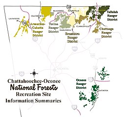
English: Map of Chattahoochee-Oconee National Forest showing ranger districts. Transwiki approved by: w:en:User:Dmcdevit. This image was copied from wikipedia:en. |
| Fecha | Fecha desconocida |
| Fuente | Chattahoochee-Oconee National Forest website |
| Autor | U.S. Forest Service |
Licencia
This image is a work of the Forest Service of the United States Department of Agriculture. As a work of the U.S. federal government, the image is in the public domain.
|
Registro original de carga
| date/time | username | resolution | size | edit summary |
|---|---|---|---|---|
| 13:39, 3 October 2006 | w:en:User:Tlmclain | 800×721 | 253 KB | From National Forest website |
Image description page history
| link | date/time | username | edit summary |
|---|---|---|---|
| http://en.wikipedia.org/w/index.php?title=Image:C-ONF_Map.jpg&redirect=no&oldid=83230379 | 23:38, 11 September 2007 | w:en:User:Dmcdevit | |
| http://en.wikipedia.org/w/index.php?title=Image:C-ONF_Map.jpg&redirect=no&oldid=83230379 | 16:28, 23 October 2006 | w:en:User:Tlmclain | |
| http://en.wikipedia.org/w/index.php?title=Image:C-ONF_Map.jpg&redirect=no&oldid=79651113 | 14:10, 5 October 2006 | w:en:User:Tlmclain | |
| http://en.wikipedia.org/w/index.php?title=Image:C-ONF_Map.jpg&redirect=no&oldid=79244131 | 13:39, 3 October 2006 | w:en:User:Tlmclain | (From National Forest website) |
Historial del archivo
Haz clic sobre una fecha y hora para ver el archivo tal como apareció en ese momento.
| Fecha y hora | Miniatura | Dimensiones | Usuario | Comentario | |
|---|---|---|---|---|---|
| actual | 16:05 13 sep 2007 | | 800 × 721 (253 kB) | BetacommandBot | Transwiki approved by: w:en:User:Dmcdevit This image was copied from wikipedia:en. The original description was: == Summary == Map of Chattahoochee-Oconee National Forest showing ranger districts. Source: [http://www.fs.fed.us/conf/district_map.htm |
Usos del archivo
La siguiente página usa este archivo:
Uso global del archivo
Las wikis siguientes utilizan este archivo:
- Uso en de.wikipedia.org
- Uso en en.wikipedia.org