Archivo:California US Congressional District 12 (since 2013).tif
Tamaño de esta previsualización PNG del archivo TIF: 800 × 394 píxeles. Otras resoluciones: 320 × 158 píxeles · 640 × 316 píxeles · 1024 × 505 píxeles · 2016 × 994 píxeles.
Ver la imagen en su resolución original (2016 × 994 píxeles; tamaño de archivo: 3,01 MB; tipo MIME: image/tiff)
Resumen
| Descripción |
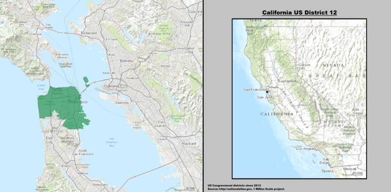
English: Boundaries for California's 12th US Federal Congressional District — in San Francisco. |
| Fecha | |
| Fuente | GIS shapefile data created by the United States Department of the Interior, as part of the "1 Million Scale" geospatial data project. Retrieved from: http://nationalatlas.gov/atlasftp-1m.html?openChapters=#chpbound |
| Autor | 1: GIS (congressional districts, 2013) shapefile data was created by the United States Department of the Interior. 2: Data was rendered using ArcGIS® software by Esri. 3: File developed for use on Wikipedia and elsewhere by 7partparadigm. |
Licencia
This map was obtained from an edition of the National Atlas of the United States. Like almost all works of the U.S. federal government, works from the National Atlas are in the public domain in the United States.
Online access: NationalAtlas.gov | 1970 print edition: Library of Congress, Perry-Castañeda Library
|
en:California's 12th congressional district
Historial del archivo
Haz clic sobre una fecha y hora para ver el archivo tal como apareció en ese momento.
| Fecha y hora | Miniatura | Dimensiones | Usuario | Comentario | |
|---|---|---|---|---|---|
| actual | 03:18 22 mar 2014 |  | 2016 × 994 (3,01 MB) | 7partparadigm | User created page with UploadWizard |
Usos del archivo
La siguiente página usa este archivo:
Uso global del archivo
Las wikis siguientes utilizan este archivo:
- Uso en en.wikipedia.org
- Uso en fr.wikipedia.org
- Uso en hu.wikipedia.org
- Uso en tr.wikipedia.org
- Uso en www.wikidata.org
- Uso en zh.wikipedia.org