Archivo:Cerro del Plomo route.jpeg

Ver la imagen en su resolución original (4224 × 2376 píxeles; tamaño de archivo: 2,43 MB; tipo MIME: image/jpeg)
Resumen
| Descripción |
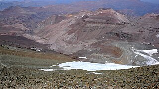
English: Looking south on most of the Cerro del Plomo route.
Somewhat to the left, near the greenish spots deep down in the Estero Cepo valley, is the Piedra Numerada base camp (approx. 3,400m). The route then follows this valley to La Hoya (or La Olla; approx. 4,200m), which is hidden by the moraine at the far right of the picture. From this moraine, the track is clearly visible on the picture, going first to the newly rebuilt Refugio Agostini (the red dot near the center of the picture; 4,620m), and then in steep hairpins (mostly hidden) to the easy traverse at the far left. From here it is less than two hours to the summit, with, immediately beyond the Pirca del Inca burial site, a short glacier crossing. El Pintor (approx. 4,200m) can be seen in the background. The Cerro del Plomo (5,424m) is not to be confused with the Nevado El Plomo (6,070m), which lies on the border about 20km to the north-east. (Cf. John Biggar, The Andes — A Guide for Climbers, ISBN 0-9536087-2-7, p. 217; Hermann Kiendler, Die Anden — Vom Chimborazo zum Marmolejo — Alle 6000er auf einen Blick, ISBN 978-3-936740-36-3, pp. 349–352.) |
| Fecha | |
| Fuente | Trabajo propio |
| Autor | Tijs Michels |
| Permiso (Reutilización de este archivo) |
cc-by-sa-3.0 (attribution required - see below) |
Licencia
- Eres libre:
- de compartir – de copiar, distribuir y transmitir el trabajo
- de remezclar – de adaptar el trabajo
- Bajo las siguientes condiciones:
- atribución – Debes otorgar el crédito correspondiente, proporcionar un enlace a la licencia e indicar si realizaste algún cambio. Puedes hacerlo de cualquier manera razonable pero no de manera que sugiera que el licenciante te respalda a ti o al uso que hagas del trabajo.
- compartir igual – En caso de mezclar, transformar o modificar este trabajo, deberás distribuir el trabajo resultante bajo la misma licencia o una compatible como el original.
Historial del archivo
Haz clic sobre una fecha y hora para ver el archivo tal como apareció en ese momento.
| Fecha y hora | Miniatura | Dimensiones | Usuario | Comentario | |
|---|---|---|---|---|---|
| actual | 20:20 21 mar 2010 | | 4224 × 2376 (2,43 MB) | Tmichels | {{Information |Description={{en|1=Looking south on most of the Cerro del Plomo route. Somewhat to the left, near the greenish spots deep down in the Estero Cepo valley, is the Piedra Numerada base camp (approx. 3,400m). The route t |
Usos del archivo
La siguiente página usa este archivo:
Uso global del archivo
Las wikis siguientes utilizan este archivo:
- Uso en ca.wikipedia.org
- Uso en en.wikipedia.org
- Uso en eo.wikipedia.org
- Uso en ru.wikipedia.org
- Uso en uk.wikipedia.org