Archivo:India Assam relief map.svg

Tamaño de esta previsualización PNG del archivo SVG: 800 × 553 píxeles. Otras resoluciones: 320 × 221 píxeles · 640 × 443 píxeles · 1024 × 708 píxeles · 1280 × 885 píxeles · 2560 × 1771 píxeles · 1414 × 978 píxeles.
Ver la imagen en su resolución original ((Imagen SVG, nominalmente 1414 × 978 pixels, tamaño de archivo: 1,95 MB))
Resumen
| Descripción |
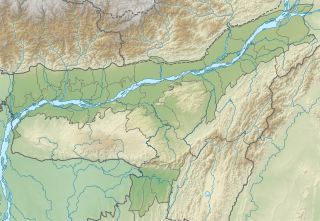
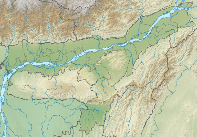
English: Assam relief map. Elevation data from STRM. |
| Fecha | |
| Fuente | Assam location map.svg |
| Autor | Milenioscuro |
Licencia
Este archivo se encuentra bajo la licencia Creative Commons Genérica de Atribución/Compartir-Igual 3.0.
- Eres libre:
- de compartir – de copiar, distribuir y transmitir el trabajo
- de remezclar – de adaptar el trabajo
- Bajo las siguientes condiciones:
- atribución – Debes otorgar el crédito correspondiente, proporcionar un enlace a la licencia e indicar si realizaste algún cambio. Puedes hacerlo de cualquier manera razonable pero no de manera que sugiera que el licenciante te respalda a ti o al uso que hagas del trabajo.
- compartir igual – En caso de mezclar, transformar o modificar este trabajo, deberás distribuir el trabajo resultante bajo la misma licencia o una compatible como el original.
Historial del archivo
Haz clic sobre una fecha y hora para ver el archivo tal como apareció en ese momento.
| Fecha y hora | Miniatura | Dimensiones | Usuario | Comentario | |
|---|---|---|---|---|---|
| actual | 04:52 2 jul 2022 | | 1414 × 978 (1,95 MB) | C1MM | Updated districts |
| 02:49 16 jul 2021 |  | 1300 × 899 (2,09 MB) | C1MM | Corrected map | |
| 03:28 17 dic 2020 |  | 983 × 679 (4,94 MB) | C1MM | Changed elevation colours | |
| 18:01 31 oct 2020 |  | 983 × 679 (4,93 MB) | C1MM | Fixed image | |
| 21:03 29 jun 2020 |  | 983 × 680 (5,06 MB) | C1MM | Uploaded a work by Milenioscuro from Assam location map.svg with UploadWizard |
Usos del archivo
Las siguientes páginas usan este archivo:
Uso global del archivo
Las wikis siguientes utilizan este archivo:
- Uso en ban.wikipedia.org
- Uso en de.wikipedia.org
- Uso en en.wikipedia.org
- Kaziranga National Park
- Sankosh River
- Dibru-Saikhowa National Park
- Hajo
- Chabua Air Force Station
- Dipor Bil
- Dihing River
- Dhansiri
- Manas River
- Hoollongapar Gibbon Sanctuary
- Hailakandi Airfield
- Ledo Airfield
- Sookerating Air Force Station
- Chandubi Lake
- Madan Kamdev
- Son Beel
- Kopili River
- Daojali Hading
- Mornoi River
- Module:Location map/data/India Assam
- Module:Location map/data/India Assam/doc
- User:Ty654/List of earthquakes from 1900-1949 exceeding magnitude 7+
- User:Ty654/List of earthquakes from 1950-1954 exceeding magnitude 6+
- Sivasagar Tank (Borpukhuri)
- Bornadi River
- User:Ty654/List of earthquakes from 1980-1984 exceeding magnitude 6+
- Puthimari River
- Lokhaitora River
- Kopili Hydro Electric Project
- User:Ty654/List of earthquakes before 1900 exceeding magnitude 8+
- Baralia River
- Pagladiya River
- Dikhow River
- Jatinga River
- Gabharu River
- Kulsi River
- Jiri River
- Aie River
- Champabati River
- Dikrong River
- Borgang River
- Nona River
- Bharalu River
- Jhanji River
- Dudhnoi River
- Krishnai River
- Ranganadi River
- Tipkai River
Ver más uso global de este archivo.