Archivo:Larose Louisiana aerial view.jpg

Tamaño de esta previsualización: 800 × 533 píxeles. Otras resoluciones: 320 × 213 píxeles · 640 × 427 píxeles · 1024 × 683 píxeles · 1500 × 1000 píxeles.
Ver la imagen en su resolución original (1500 × 1000 píxeles; tamaño de archivo: 278 kB; tipo MIME: image/jpeg)
| Descripción |
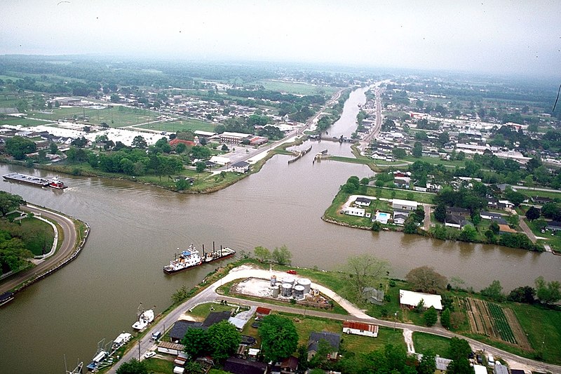
English: Aerial view of the intersection of Bayou Lafourche and the Gulf Intracoastal Waterway at Larose, Louisiana, USA. The waterway runs left–right across the photograph and the bayou runs off into the distance at the top. The U.S. Army Corps of Engineers has installed a floodgate on the bayou, visible at center. |
|||
| Fecha | ||||
| Fuente |
U.S. Army Corps of Engineers Digital Visual Library Image page Image description page Digital Visual Library home page |
|||
| Autor | Arthur Belala, U.S. Army Corps of Engineers | |||
| Permiso (Reutilización de este archivo) |
|
|||
| Localización | Larose, Louisiana, USA |
| Posición de la cámara | | Ubicación de esta y otras imágenes en: OpenStreetMap |
|---|
Historial del archivo
Haz clic sobre una fecha y hora para ver el archivo tal como apareció en ese momento.
| Fecha y hora | Miniatura | Dimensiones | Usuario | Comentario | |
|---|---|---|---|---|---|
| actual | 16:28 1 abr 2007 | | 1500 × 1000 (278 kB) | DanMS | {{Information | Description = {{en|Aerial view of the intersection of Bayou Lafourche and the Gulf Intracoastal Waterway at Larose, Louisiana, USA. The bayou runs left–right across the photograph and the waterway runs off into the distance at the top |
Usos del archivo
La siguiente página usa este archivo:
Uso global del archivo
Las wikis siguientes utilizan este archivo:
- Uso en ar.wikipedia.org
- Uso en azb.wikipedia.org
- Uso en ca.wikipedia.org
- Uso en ceb.wikipedia.org
- Uso en ce.wikipedia.org
- Uso en de.wikipedia.org
- Uso en en.wikipedia.org
- Uso en fa.wikipedia.org
- Uso en fr.wikipedia.org
- Uso en it.wikipedia.org
- Uso en ja.wikipedia.org
- Uso en lld.wikipedia.org
- Uso en pl.wikipedia.org
- Uso en pt.wikipedia.org
- Uso en sh.wikipedia.org
- Uso en sr.wikipedia.org
- Uso en tt.wikipedia.org
- Uso en uk.wikipedia.org
- Uso en www.wikidata.org
- Uso en zh-min-nan.wikipedia.org
- Uso en zh.wikipedia.org