Archivo:NIT Combined Flights Ground Measurements 30Mar 03Apr2011 results.jpg

Tamaño de esta previsualización: 800 × 555 píxeles. Otras resoluciones: 320 × 222 píxeles · 640 × 444 píxeles · 1024 × 710 píxeles · 1245 × 863 píxeles.
Ver la imagen en su resolución original (1245 × 863 píxeles; tamaño de archivo: 612 kB; tipo MIME: image/jpeg)
Resumen
| Descripción |
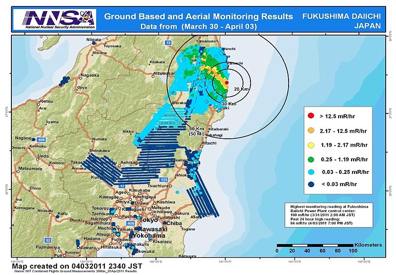
English: Combined results of 211 flight hours of aerial monitoring operations and ground measurements made by DOE, DoD and Japanese monitoring teams. |
| Fecha | |
| Fuente | 4th slide of http://energy.gov/news/documents/AMS_Data_April_4__v1.pptx available at http://blog.energy.gov/content/situation-japan |
| Autor | National Nuclear Security Administration (NNSA) US Department of Energy |
| Otras versiones |
|


Licencia
| This image is a work of a United States Department of Energy (or predecessor organization) employee, taken or made as part of that person's official duties. As a work of the U.S. federal government, the image is in the public domain.
Please note that national laboratories operate under varying licences and some are not free. Check the site policies of any national lab before crediting it with this tag.
|

|
Historial del archivo
Haz clic sobre una fecha y hora para ver el archivo tal como apareció en ese momento.
| Fecha y hora | Miniatura | Dimensiones | Usuario | Comentario | |
|---|---|---|---|---|---|
| actual | 09:36 9 abr 2011 | | 1245 × 863 (612 kB) | Teofilo | cropped |
| 09:26 9 abr 2011 |  | 1920 × 1080 (689 kB) | Teofilo | {{Information |Description ={{en|1=Combined results of 211 flight hours of aerial monitoring operations and ground measurements made by DOE, DoD and Japanese monitoring teams.}} |Source =4th slide of http://energy.gov/news/documents/AMS_Data_Ap |
Usos del archivo
La siguiente página usa este archivo:
Uso global del archivo
Las wikis siguientes utilizan este archivo:
- Uso en bg.wikipedia.org
- Uso en de.wikipedia.org
- Uso en en.wikipedia.org
- Uso en en.wikibooks.org
- Uso en it.wikipedia.org
- Uso en ja.wikipedia.org
- Uso en pl.wikipedia.org
- Uso en pt.wikipedia.org
- Uso en so.wikipedia.org
- Uso en sr.wikinews.org
- Uso en th.wikipedia.org
- Uso en www.wikidata.org
- Uso en zh.wikipedia.org