Archivo:Nemegtomaia maps.png

Tamaño de esta previsualización: 800 × 407 píxeles. Otras resoluciones: 320 × 163 píxeles · 640 × 326 píxeles · 1024 × 521 píxeles · 1280 × 651 píxeles · 3397 × 1729 píxeles.
Ver la imagen en su resolución original (3397 × 1729 píxeles; tamaño de archivo: 4,66 MB; tipo MIME: image/png)
Resumen
| Descripción |
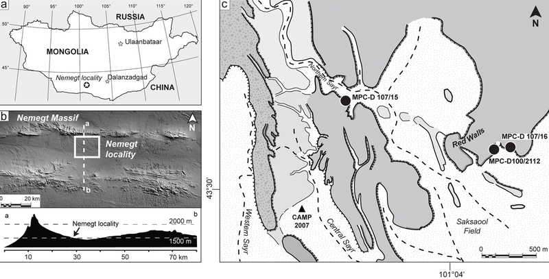
The Nemegt locality the Gobi Desert, southern Mongolia. A, map showing the location of the study area within southern Mongolia; B, the Nemegt area is located a few kilometers south of the massif of the same name; C, a detail of the Nemegt locality (sensu 5), showing the exact locations of Nemegtomaia specimens described in this study. |
| Fecha | |
| Fuente | http://www.plosone.org/article/info%3Adoi%2F10.1371%2Fjournal.pone.0031330 |
| Autor | Federico Fanti, Philip J. Currie, Demchig Badamgarav |
Licencia
|
Este archivo está disponible bajo la licencia Creative Commons Reconocimiento 2.5 Genérica.
|
This file was published in a Public Library of Science journal. Their website states that the content of all PLOS journals is published under the Creative Commons Attribution 4.0 license (or its previous version depending on the publication date), unless indicated otherwise.
|
Este archivo, el cual fue publicado originalmente en http://www.plosone.org/article/info%3Adoi%2F10.1371%2Fjournal.pone.0031330, fue revisado el 30 March 2016 por el revisor Dyolf77, quien confirmó que en esa fecha estaba disponible bajo la licencia indicada.
|
Historial del archivo
Haz clic sobre una fecha y hora para ver el archivo tal como apareció en ese momento.
| Fecha y hora | Miniatura | Dimensiones | Usuario | Comentario | |
|---|---|---|---|---|---|
| actual | 21:53 24 oct 2018 | | 3397 × 1729 (4,66 MB) | FunkMonk | Cropped 1 % horizontally, 1 % vertically using CropTool with precise mode. |
| 22:35 8 sep 2016 |  | 3446 × 1753 (4,72 MB) | FunkMonk | == {{int:filedesc}} == {{Information |Description=The Nemegt locality the Gobi Desert, southern Mongolia. A, map showing the location of the study area within southern Mongolia; B, the Nemegt area is located a few kilometers south of the massif of the... |
Usos del archivo
La siguiente página usa este archivo:
Uso global del archivo
Las wikis siguientes utilizan este archivo:
- Uso en de.wikipedia.org
- Uso en en.wikipedia.org
- Uso en fa.wikipedia.org
- Uso en nl.wikipedia.org
- Uso en pl.wikipedia.org
- Uso en zh.wikipedia.org