Archivo:Newton rebellion stone (geograph 4105909).jpg

Tamaño de esta previsualización: 400 × 600 píxeles. Otras resoluciones: 160 × 240 píxeles · 320 × 480 píxeles · 683 × 1024 píxeles.
Ver la imagen en su resolución original (683 × 1024 píxeles; tamaño de archivo: 273 kB; tipo MIME: image/jpeg)
.jpg?uselang=es)
Resumen
| Descripción |
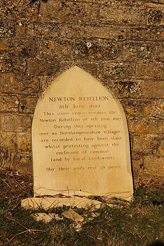
English: Newton rebellion stone by Newton Field Centre commemorating the Newton Rebellion on 8th June 1607.
In the early years of the reign of King James I, powerful midlands landowners started enclosing common land for their estates, locally this was the Treshams of Rushton and their cousins at Newton. Large protest gatherings of thousands of peasants took place, led by Captain Pouch and calling themselves diggers and levellers. James I issued a proclamation for the suppression of the Midland Revolt on 30th May 1607 and on 8th June a huge protest at Newton by over a thousand peasants was brutally dispersed by an army raised by the Treshams as over 40 of the protesters were killed. The ringleaders were captured and imprisoned in St.Faith's church before being tried, hanged and quartered. |
| Fecha | |
| Fuente | From geograph.org.uk |
| Autor | Richard Croft |
| Permiso (Reutilización de este archivo) |
Creative Commons Attribution Share-alike license 2.0 |
| Atribución (requerido por la licencia) | Richard Croft / Newton rebellion stone / |
| Posición de la cámara | | Ubicación de esta y otras imágenes en: OpenStreetMap |
|---|
.jpg¶ms=052.440257_N_-000.700666_E_globe:Earth_type:camera_source:geograph-osgb36(SP88428327)_heading:90.00&language=es)
| Ubicación del objeto | | Ubicación de esta y otras imágenes en: OpenStreetMap |
|---|
.jpg¶ms=052.440260_N_-000.700670_E_globe:Earth_class:object_type:object_source:geograph-osgb36(SP88428327)_heading:90.00&language=es)
Licencia

|
Esta imagen proviene de la colección del proyecto Geograph British Isles. Veáse la página de esta fotografía en el sitio web de Geograph para más información del fotógrafo. El titular de los derechos de autor de esta imagen es Richard Croft y autoriza utilizarla bajo la licencia Reconocimiento-CompartirIgual 2.0 de Creative Commons.
|
Este archivo se encuentra bajo la licencia Creative Commons Genérica de Atribución/Compartir-Igual 2.0.
Atribución: Richard Croft
- Eres libre:
- de compartir – de copiar, distribuir y transmitir el trabajo
- de remezclar – de adaptar el trabajo
- Bajo las siguientes condiciones:
- atribución – Debes otorgar el crédito correspondiente, proporcionar un enlace a la licencia e indicar si realizaste algún cambio. Puedes hacerlo de cualquier manera razonable pero no de manera que sugiera que el licenciante te respalda a ti o al uso que hagas del trabajo.
- compartir igual – En caso de mezclar, transformar o modificar este trabajo, deberás distribuir el trabajo resultante bajo la misma licencia o una compatible como el original.
Historial del archivo
Haz clic sobre una fecha y hora para ver el archivo tal como apareció en ese momento.
| Fecha y hora | Miniatura | Dimensiones | Usuario | Comentario | |
|---|---|---|---|---|---|
| actual | 11:06 9 oct 2022 | | 683 × 1024 (273 kB) | Wilfridselsey | == {{int:filedesc}} == {{Information |Description={{en|1=Newton rebellion stone}} |Source=From [https://www.geograph.org.uk/photo/4105909 geograph.org.uk] |Date=2014-08-03 |Author=[https://www.geograph.org.uk/profile/1904 Richard Croft] |Permission=Creative Commons Attribution Share-alike license 2.0 |Other fields={{Credit line |Author=Richard Croft |License=[https://creativecommons.org/licenses/by-sa/2.0/ CC BY-SA 2.0] |Other=''Newton rebellion stone'' }} }} {{Location|52.440257|-0.70066... |
Usos del archivo
La siguiente página usa este archivo:
Uso global del archivo
Las wikis siguientes utilizan este archivo:
- Uso en en.wikipedia.org
.jpg)