Archivo:NorthAmerica-WaterDivides.png

Tamaño de esta previsualización: 600 × 600 píxeles. Otras resoluciones: 240 × 240 píxeles · 480 × 480 píxeles · 900 × 900 píxeles.
Ver la imagen en su resolución original (900 × 900 píxeles; tamaño de archivo: 370 kB; tipo MIME: image/png)
Resumen
| Descripción |
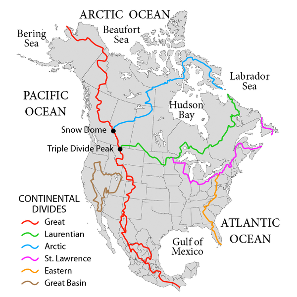
English: Map showing the major Continental divides of North America, following the style of File:NorthAmericaDivides.gif and intended as a replacement. Made using File:BlankMap-North America-Subdivisions.svg as a base map. Various maps and other sources consulted, such as: File:Ocean drainage.png, Drainage Basins, The Atlas of Canada, http://www.cec.org/atlas/files/watersheds/na_watersheds_en.jpg, and others. Note: the Eastern watershed boundary in the southern areas (orange line), and the St. Lawrence watershed boundary in the northern areas (magenta line) of this map more or less defined the Royal Proclamation's western boundaries. |
| Fecha | |
| Fuente | Trabajo propio |
| Autor | Pfly |
Licencia
Yo, titular de los derechos de autor de esta obra, la publico en los términos de las siguientes licencias:
Este archivo se encuentra bajo la licencia Creative Commons Genérica de Atribución/Compartir-Igual 3.0.
- Eres libre:
- de compartir – de copiar, distribuir y transmitir el trabajo
- de remezclar – de adaptar el trabajo
- Bajo las siguientes condiciones:
- atribución – Debes otorgar el crédito correspondiente, proporcionar un enlace a la licencia e indicar si realizaste algún cambio. Puedes hacerlo de cualquier manera razonable pero no de manera que sugiera que el licenciante te respalda a ti o al uso que hagas del trabajo.
- compartir igual – En caso de mezclar, transformar o modificar este trabajo, deberás distribuir el trabajo resultante bajo la misma licencia o una compatible como el original.

|
Se autoriza la copia, distribución y modificación de este documento bajo los términos de la licencia de documentación libre GNU, versión 1.2 o cualquier otra que posteriormente publique la Fundación para el Software Libre; sin secciones invariables, textos de portada, ni textos de contraportada. Se incluye una copia de la dicha licencia en la sección titulada Licencia de Documentación Libre GNU. |
Puedes usar la licencia que prefieras.
Historial del archivo
Haz clic sobre una fecha y hora para ver el archivo tal como apareció en ese momento.
| Fecha y hora | Miniatura | Dimensiones | Usuario | Comentario | |
|---|---|---|---|---|---|
| actual | 02:47 1 oct 2019 | | 900 × 900 (370 kB) | Palaeozoic99 | Correct St. Lawrence |
| 07:12 22 nov 2018 |  | 900 × 900 (440 kB) | Pfly | Try to remove transparency one more time, sigh | |
| 06:51 22 nov 2018 |  | 900 × 900 (290 kB) | Pfly | Reverting to original with non-transparent background, as the transparency was displaying very badly, even unreadably, on mobile devices | |
| 06:49 22 nov 2018 |  | 900 × 900 (256 kB) | Pfly | revert my own reversion--made mistake | |
| 06:44 22 nov 2018 |  | 900 × 900 (290 kB) | Pfly | Reverted to version as of 21:09, 23 November 2010 (UTC): Transparent background looks very bad, even unreadable on mobile. | |
| 02:46 15 jul 2012 |  | 900 × 900 (256 kB) | Ubiquinoid | mildly updated: including names of oceans/seas in vicinity of North America (as displayed), per IHO | |
| 02:43 15 jul 2012 |  | 900 × 900 (256 kB) | Ubiquinoid | mildly updated: including names of oceans/seas in vicinity of North America (as displayed), per IHO | |
| 21:09 23 nov 2010 |  | 900 × 900 (290 kB) | Pfly | {{Information |Description={{en|1=Map showing the major Continental divides of North America, following the style of File:NorthAmericaDivides.gif and intended as a replacement. Made using [[:File:BlankMap-North America-Subd |
Usos del archivo
Las siguientes páginas usan este archivo:
Uso global del archivo
Las wikis siguientes utilizan este archivo:
- Uso en ar.wikipedia.org
- Uso en cs.wikipedia.org
- Uso en de.wikipedia.org
- Uso en en.wikipedia.org
- North America
- List of rivers of the Americas
- Royal Proclamation of 1763
- Continental Divide of the Americas
- Rupert's Land
- Pigeon River (Minnesota–Ontario)
- Atlantic seaboard watershed
- Eastern Continental Divide
- Talk:Kensington Runestone
- Talk:List of lighthouses in the United States
- Great Divide Basin
- Central United States
- Triple Divide Peak (Montana)
- Chicago Portage
- Snow Dome (Canada)
- Hudson Bay drainage basin
- Geography of North America
- Laurentian Divide
- Continental divide
- Great Basin Divide
- Watersheds of North America
- Canadian canoe routes
- Voyageurs
- Pacific Slope
- Centennial Voyageur Canoe Pageant
- Triple divide
- St. Lawrence River Divide
- Timeline of Alberta history
- Uso en en.wiktionary.org
- Uso en eo.wikipedia.org
- Uso en fr.wikipedia.org
- Uso en hr.wikipedia.org
- Uso en id.wikipedia.org
- Uso en ig.wikipedia.org
- Uso en it.wikipedia.org
- Uso en ja.wikipedia.org
- Uso en km.wikipedia.org
Ver más uso global de este archivo.