Archivo:PNW-straits.jpg
No se dispone de una resolución más alta.
PNW-straits.jpg (336 × 396 píxeles; tamaño de archivo: 128 kB; tipo MIME: image/jpeg)
Resumen
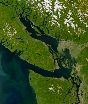
| Descripción | Satellite image of the Strait of Georgia, Strait of Juan de Fuca, and surrounding region. The image was acquired by the Sea-viewing Wide Field-of-view Sensor (SeaWiFS) on August 9, 2001. Original image cropped to highlight the Strait of Georgia. |
| Fecha | |
| Fuente | NASAEarth Observatory, http://earthobservatory.nasa.gov/Newsroom/NewImages/images.php3?img_id=5051 |
| Autor | The SeaWiFS Project, NASA/Goddard Space Flight Center, and ORBIMAGE |
Licencia
| This image is from the Sea-viewing Wide Field-of-view Sensor (SeaWiFS) Project and more than 5 years old.
Satellite data captured by the SeaWIFS sensor are released into the public domain 5 years after capture. Data less than five years old can be re-used only for educational or scientific purposes; any commercial use of such images must be coordinated with GeoEye. [1] |
| This work has been released into the public domain by its copyright holder, GeoEye. This applies worldwide. En algunos países esto puede no ser legalmente factible; si ello ocurriese: GeoEye otorga a cualquier persona el derecho de usar este trabajo para cualquier propósito, sin ningún tipo de condición, a menos que éstas sean requeridas por la ley.
|
Historial del archivo
Haz clic sobre una fecha y hora para ver el archivo tal como apareció en ese momento.
| Fecha y hora | Miniatura | Dimensiones | Usuario | Comentario | |
|---|---|---|---|---|---|
| actual | 06:55 22 abr 2008 | | 336 × 396 (128 kB) | Pfly | {{Information |Description=Satellite image of the Strait of Georgia, Strait of Juan de Fuca, and surrounding region. The image was acquired by the Sea-viewing Wide Field-of-view Sensor (SeaWiFS) on |
Usos del archivo
Las siguientes páginas usan este archivo:
Uso global del archivo
Las wikis siguientes utilizan este archivo:
- Uso en ar.wikipedia.org
- Uso en ast.wikipedia.org
- Uso en az.wikipedia.org
- Uso en br.wikipedia.org
- Uso en ca.wikipedia.org
- Uso en cv.wikipedia.org
- Uso en de.wikipedia.org
- Uso en en.wikipedia.org
- Uso en eo.wikipedia.org
- Uso en fa.wikipedia.org
- Uso en fi.wikipedia.org
- Uso en fr.wikipedia.org
- Uso en fr.wiktionary.org
- Uso en fy.wikipedia.org
- Uso en he.wikipedia.org
- Uso en id.wikipedia.org
- Uso en is.wikipedia.org
- Uso en it.wikipedia.org
- Uso en ja.wikipedia.org
- Uso en ko.wikipedia.org
- Uso en lv.wikipedia.org
- Uso en mhr.wikipedia.org
- Uso en mk.wikipedia.org
- Uso en ms.wikipedia.org
- Uso en nl.wikipedia.org
- Uso en no.wikipedia.org
- Uso en pl.wikipedia.org
- Uso en pt.wikipedia.org
- Uso en ru.wikipedia.org
- Uso en sh.wikipedia.org
- Uso en tr.wikipedia.org
- Uso en uk.wikipedia.org
- Uso en ur.wikipedia.org
- Uso en vi.wikipedia.org
- Uso en zh.wikipedia.org