Archivo:Partition of Hungary.png
No se dispone de una resolución más alta.
Partition_of_Hungary.png (389 × 328 píxeles; tamaño de archivo: 31 kB; tipo MIME: image/png)
Resumen

| Descripción |
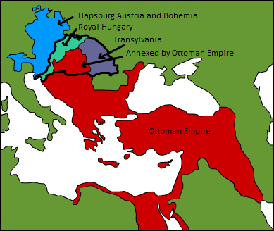
A map displaying position of the Kingdom of Hungary before 1541, and the 3 parts into which it was divided after the occupation of Buda in 1541: Royal Hungary, Eastern Hungarian kingdom, and the part that was annexed by the Ottoman Empire. en:Category:Maps of the history of Hungary |
| Fecha | 3 de septiembre de 2006 (fecha original de carga) |
| Fuente | Transferido desde en.wikipedia a Commons. |
| Autor |
Esoltas de Wikipedia en inglés Later versions were uploaded by PANONIAN, DonatusHR at en.wikipedia. |
Licencia
| Este trabajo ha sido liberado al dominio público por su autor, Esoltas de Wikipedia en inglés. Esto aplica para todo el mundo. En algunos países esto puede no ser legalmente factible; si ello ocurriese: Esoltas otorga a cualquier persona el derecho de usar este trabajo para cualquier propósito, sin ningún tipo de condición, a menos que éstas sean requeridas por la ley. |
Registro original de carga
Aquí se muestra la página de descripción original. Los siguientes nombres de usuario se refieren a en.wikipedia.
- 2007-08-12 15:14 DonatusHR 389×328×8 (38357 bytes) Vraćeno na prijašnju inačicu
- 2007-08-12 15:13 DonatusHR 389×328×8 (35596 bytes) Vraćeno na prijašnju inačicu
- 2006-10-11 10:58 PANONIAN 389×328×8 (38357 bytes) corrected image
- 2006-09-03 15:00 Esoltas 389×328×8 (35596 bytes) A map displaying the original position of the Kingdom of Hungary, and the 3 lands that became of it after the Battle of Mohács: Royal Hungary, Transylvania, and the Ottoman-occupied section.
Historial del archivo
Haz clic sobre una fecha y hora para ver el archivo tal como apareció en ese momento.
| Fecha y hora | Miniatura | Dimensiones | Usuario | Comentario | |
|---|---|---|---|---|---|
| actual | 17:22 12 feb 2016 | | 389 × 328 (31 kB) | Packare | better caption |
| 17:58 10 sep 2007 |  | 389 × 328 (37 kB) | Sir Iain | {{Information |Description=A map displaying position of the Kingdom of Hungary before 1526, and the 3 parts into which it was divided after the Battle of Mohács: Royal Hungary, Transylvania, and the part that was annexed by the Ottoman Empire. [[:en:Ca |
Usos del archivo
Las siguientes páginas usan este archivo:
Uso global del archivo
Las wikis siguientes utilizan este archivo:
- Uso en ar.wikipedia.org
- Uso en azb.wikipedia.org
- Uso en de.wikipedia.org
- Uso en el.wikipedia.org
- Uso en en.wikipedia.org
- Uso en fr.wikipedia.org
- Uso en gl.wikipedia.org
- Uso en hu.wikipedia.org
- Uso en io.wikipedia.org
- Uso en it.wikipedia.org
- Uso en ja.wikipedia.org
- Uso en ko.wikipedia.org
- Uso en lv.wikipedia.org
- Uso en nl.wikipedia.org
- Uso en sk.wikipedia.org
- Uso en trv.wikipedia.org
- Uso en tr.wikipedia.org
- Uso en uk.wikipedia.org
- Uso en uz.wikipedia.org
- Uso en zh.wikipedia.org