Archivo:Payette National Forest Map.jpg

Tamaño de esta previsualización: 800 × 474 píxeles. Otras resoluciones: 320 × 190 píxeles · 640 × 379 píxeles · 1024 × 607 píxeles · 1280 × 758 píxeles · 2560 × 1516 píxeles · 9496 × 5625 píxeles.
Ver la imagen en su resolución original (9496 × 5625 píxeles; tamaño de archivo: 16,72 MB; tipo MIME: image/jpeg)
| Atención | El archivo original tiene un número considerable de píxeles; si se abre en su resolución original, es posible que no se cargue correctamente o que provoque un bloqueo en el funcionamiento del navegador. Para evitar estos problemas puede utilizarse ZoomViewer. |
|---|
Resumen
| Descripción |
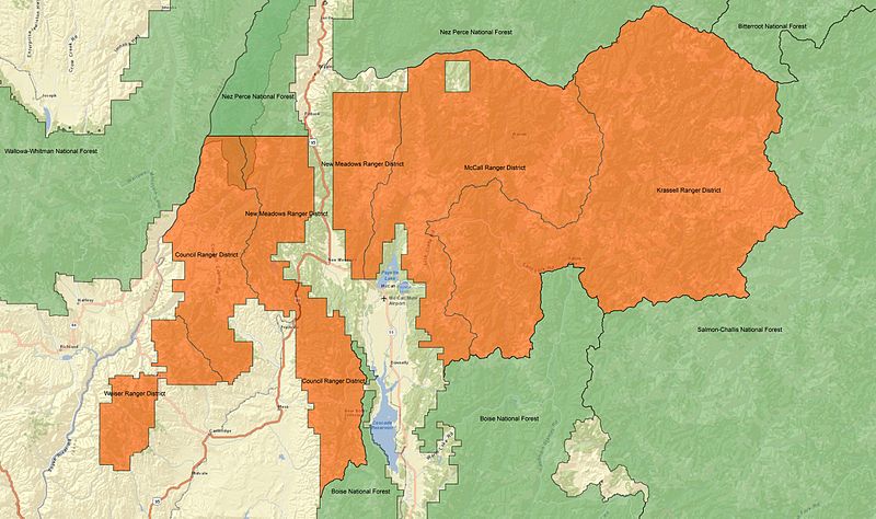
English: A map of Payette National Forest in Idaho. The Council, Krassell, McCall, New Meadows, and Weiser Ranger Districts of Payette National Forest are in orange. Surrounding National Forests, including Boise, Nez Perce, Wallowa-Whitman, and Salmon-Challis are in green.
This map was made using ARCGIS 10, and all data are in the public domain. Forest Service boundary data are from the US Forest Service FSGeodata Clearinghouse |
| Fecha | |
| Fuente | Trabajo propio |
| Autor | Fredlyfish4 |
Licencia
Yo, el titular de los derechos de autor de esta obra, la publico en los términos de la siguiente licencia:
Este archivo se encuentra bajo la licencia Creative Commons Genérica de Atribución/Compartir-Igual 3.0.
- Eres libre:
- de compartir – de copiar, distribuir y transmitir el trabajo
- de remezclar – de adaptar el trabajo
- Bajo las siguientes condiciones:
- atribución – Debes otorgar el crédito correspondiente, proporcionar un enlace a la licencia e indicar si realizaste algún cambio. Puedes hacerlo de cualquier manera razonable pero no de manera que sugiera que el licenciante te respalda a ti o al uso que hagas del trabajo.
- compartir igual – En caso de mezclar, transformar o modificar este trabajo, deberás distribuir el trabajo resultante bajo la misma licencia o una compatible como el original.
| File created by Fredlyfish4 | |
| Permission is granted for use under CC BY-SA 4.0 (or a similar license) for this file created by the author.
Please let the author know if you use this work outside of Wikimedia projects by sending an email to
|
Historial del archivo
Haz clic sobre una fecha y hora para ver el archivo tal como apareció en ese momento.
| Fecha y hora | Miniatura | Dimensiones | Usuario | Comentario | |
|---|---|---|---|---|---|
| actual | 22:02 12 nov 2012 | | 9496 × 5625 (16,72 MB) | Fredlyfish4 | User created page with UploadWizard |
Usos del archivo
La siguiente página usa este archivo:
Uso global del archivo
Las wikis siguientes utilizan este archivo:
- Uso en en.wikipedia.org