Archivo:Periplous of the Erythraean Sea.svg

Tamaño de esta previsualización PNG del archivo SVG: 800 × 564 píxeles. Otras resoluciones: 320 × 226 píxeles · 640 × 452 píxeles · 1024 × 722 píxeles · 1280 × 903 píxeles · 2560 × 1806 píxeles.
Ver la imagen en su resolución original ((Imagen SVG, nominalmente 1280 × 903 pixels, tamaño de archivo: 1,39 MB))
Resumen
| Descripción |
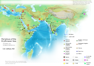
English: Periplous of the Erythreaen Sea map, according to the description from source text (https://el.wikisource.org/wiki/Περίπλους_τῆς_Ἐρυθράς_Θαλάσσης). Original names have been transcribed to Latin alphabet when possible. For the Greek names look at the respective Greek version of the map.
Ελληνικά: Χάρτης του περίπλου της Ερυθράς Θαλάσσης(Αγγλική έκδοση), σύμφωνα με την περιγραφή του κειμένου (https://el.wikisource.org/wiki/Περίπλους_τῆς_Ἐρυθράς_Θαλάσσης). हिन्दी: एरिथ्रेअन सागर के पेरिप्लस के नाम, मार्ग और स्थान
Català: Mapa del Periple de la Mar Eritrea, segons la descripció de la font (https://el.wikisource.org/wiki/Περίπλους_τῆς_Ἐρυθράς_Θαλάσσης). Els noms originals s'han transcrit a l'alfabet llatí quan ha estat possible. Per als noms grecs mireu la versió grega del mapa. |
| Fecha | |
| Fuente | Trabajo propio |
| Autor | George Tsiagalakis |
| Permiso (Reutilización de este archivo) |
Mention author and licence when using this work, e.g. "George Tsiagalakis / CC-BY-SA-4 licence" |
| Otras versiones |
|


|
Este archivo SVG contiene texto incrustado que puede traducirse a su lengua, mediante un editor que admita SVG (como XML o texto). Para más información, véase: Sobre la traducción de archivos SVG. |
Licencia
Yo, el titular de los derechos de autor de esta obra, la publico en los términos de la siguiente licencia:
| Multi-licensed with all versions of the Creative Commons Attribution Share-Alike License | ||
| I agree to multi-license my contributions, unless otherwise stated, under the GFDL and the Creative Commons Attribution Share-Alike license version 1.0, version 2.0, version 2.5, version 3.0, and all future versions of the Creative Commons Attribution Share-Alike license. Please be aware that other contributors might not do the same, so if you want to use my contributions under the Creative Commons terms, please check the CC dual-license and Multi-licensing guides. | ||

|
Se autoriza la copia, distribución y modificación de este documento bajo los términos de la licencia de documentación libre GNU, versión 1.2 o cualquier otra que posteriormente publique la Fundación para el Software Libre; sin secciones invariables, textos de portada, ni textos de contraportada. Se incluye una copia de la dicha licencia en la sección titulada Licencia de Documentación Libre GNU. |
This file is licensed under the Creative Commons Attribution-Share Alike 4.0 International, 3.0 Unported, 2.5 Generic, 2.0 Generic and 1.0 Generic license.
- Eres libre:
- de compartir – de copiar, distribuir y transmitir el trabajo
- de remezclar – de adaptar el trabajo
- Bajo las siguientes condiciones:
- atribución – Debes otorgar el crédito correspondiente, proporcionar un enlace a la licencia e indicar si realizaste algún cambio. Puedes hacerlo de cualquier manera razonable pero no de manera que sugiera que el licenciante te respalda a ti o al uso que hagas del trabajo.
- compartir igual – En caso de mezclar, transformar o modificar este trabajo, deberás distribuir el trabajo resultante bajo la misma licencia o una compatible como el original.
Historial del archivo
Haz clic sobre una fecha y hora para ver el archivo tal como apareció en ese momento.
| Fecha y hora | Miniatura | Dimensiones | Usuario | Comentario | |
|---|---|---|---|---|---|
| actual | 17:48 29 sep 2023 | | 1280 × 903 (1,39 MB) | Joutbis | File uploaded using svgtranslate tool (https://svgtranslate.toolforge.org/). Added translation for ca. |
| 17:33 29 sep 2023 |  | 1280 × 903 (1,38 MB) | Joutbis | File uploaded using svgtranslate tool (https://svgtranslate.toolforge.org/). Added translation for ca. | |
| 21:13 1 feb 2023 |  | 1280 × 903 (1,32 MB) | Theklan | File uploaded using svgtranslate tool (https://svgtranslate.toolforge.org/). Added translation for eu. | |
| 19:12 9 ene 2022 |  | 1280 × 903 (1,28 MB) | Mr. Ibrahem | Reverted to version as of 11:44, 6 May 2021 (UTC) | |
| 13:29 9 ene 2022 |  | 1280 × 903 (1,28 MB) | Mr. Ibrahem | File uploaded using svgtranslate tool (https://svgtranslate.toolforge.org/). Added translation for ar. | |
| 11:44 6 may 2021 |  | 1280 × 903 (1,28 MB) | Andrei Stroe | File uploaded using svgtranslate tool (https://svgtranslate.toolforge.org/). Added translation for ro. | |
| 16:10 31 ene 2015 |  | 1280 × 903 (1,28 MB) | Gts-tg | Small updates in spelling of city names | |
| 15:39 31 ene 2015 |  | 1280 × 903 (1,28 MB) | Gts-tg | More accurate positioning for Nikon(os) and Sarapion(os), corresponding to modern Barawe and Mogadishu respectively. Improved legibility of place names | |
| 03:15 29 ene 2015 |  | 1280 × 903 (1,28 MB) | Gts-tg | Updates as [https://en.wikipedia.org/wiki/User_talk:Gts-tg#Periplus_svg indicated by Wikipedia editors] | |
| 17:31 26 dic 2014 |  | 1280 × 903 (1,28 MB) | Gts-tg | User created page with UploadWizard |
Usos del archivo
Las siguientes páginas usan este archivo:
Uso global del archivo
Las wikis siguientes utilizan este archivo:
- Uso en af.wikipedia.org
- Uso en ar.wikipedia.org
- Uso en arz.wikipedia.org
- Uso en az.wikipedia.org
- Uso en bg.wikipedia.org
- Uso en bn.wikipedia.org
- Uso en ca.wikipedia.org
- Uso en ceb.wikipedia.org
- Uso en cs.wikipedia.org
- Uso en da.wikipedia.org
- Uso en de.wikipedia.org
- Uso en el.wikipedia.org
- Uso en en.wikipedia.org
- Arabian Sea
- History of Cambodia
- Foreign relations of Ethiopia
- Red Sea
- Kozhikode
- Kochi
- Malappuram district
- Tamils
- Roman Egypt
- Spice trade
- Trade route
- Bharuch
- History of South India
- Kollam
- Barbarikon
- Hippalus
- Islam in India
- Opone
- Mappila Muslims
- Sino-Roman relations
- Christianity in India
- Timeline of international trade
Ver más uso global de este archivo.