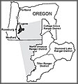
Archivo:Umpqua Vicinity Map.jpg
Umpqua_Vicinity_Map.jpg (270 × 290 píxeles; tamaño de archivo: 15 kB; tipo MIME: image/jpeg)
Historial del archivo
Haz clic sobre una fecha y hora para ver el archivo tal como apareció en ese momento.
| Fecha y hora | Miniatura | Dimensiones | Usuario | Comentario | |
|---|---|---|---|---|---|
| actual | 10:47 20 mar 2009 |  | 270 × 290 (15 kB) | Urdangaray | {{Information |Description={{en|Vicinity map of the Umpqua National Forest, from the US Forest Service website. http://www.fs.fed.us/r6/umpqua/about/}} |Source=Transferred from [http://en.wikipedia.org en.wikipedia] |Date=2007-12-13 (original upload date |
Usos del archivo
Las siguientes páginas usan este archivo:
Uso global del archivo
Las wikis siguientes utilizan este archivo:
- Uso en en.wikipedia.org
- Uso en he.wikipedia.org
- Uso en zh.wikipedia.org

