Archivo:Zhujiangrivermap.png
Tamaño de esta previsualización: 800 × 542 píxeles. Otras resoluciones: 320 × 217 píxeles · 640 × 433 píxeles · 988 × 669 píxeles.
Ver la imagen en su resolución original (988 × 669 píxeles; tamaño de archivo: 308 kB; tipo MIME: image/png)
Resumen
| Descripción |
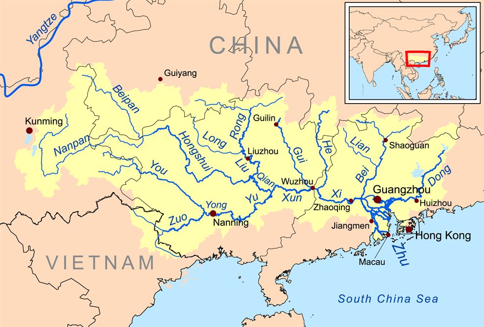
English: Map of the tributaries of the Pearl River, and the Pearl River Basin (watershed/drainage basin) in yellow.
|
| Fecha | |
| Fuente | Trabajo propio |
| Autor | Kmusser |
| Otras versiones | estonio |
Licencia
Yo, el titular de los derechos de autor de esta obra, la publico en los términos de la siguiente licencia:
Este archivo se encuentra bajo la licencia Creative Commons Genérica de Atribución/Compartir-Igual 3.0.
- Eres libre:
- de compartir – de copiar, distribuir y transmitir el trabajo
- de remezclar – de adaptar el trabajo
- Bajo las siguientes condiciones:
- atribución – Debes otorgar el crédito correspondiente, proporcionar un enlace a la licencia e indicar si realizaste algún cambio. Puedes hacerlo de cualquier manera razonable pero no de manera que sugiera que el licenciante te respalda a ti o al uso que hagas del trabajo.
- compartir igual – En caso de mezclar, transformar o modificar este trabajo, deberás distribuir el trabajo resultante bajo la misma licencia o una compatible como el original.
Historial del archivo
Haz clic sobre una fecha y hora para ver el archivo tal como apareció en ese momento.
| Fecha y hora | Miniatura | Dimensiones | Usuario | Comentario | |
|---|---|---|---|---|---|
| actual | 13:59 21 dic 2015 | | 988 × 669 (308 kB) | Ras67 | cropped |
| 20:09 19 nov 2008 |  | 1000 × 681 (346 kB) | Kmusser | {{Information |Description=This is a map of the Pearl River drainage basin. |Source=Own work using http://www.maproom.psu.edu/dcw/ Digital Chart of the World and [[http://edc.usgs.gov/products/elevation/gtopo30/gtopo30.html |
Usos del archivo
Las siguientes páginas usan este archivo:
Uso global del archivo
Las wikis siguientes utilizan este archivo:
- Uso en af.wikipedia.org
- Uso en ar.wikipedia.org
- Uso en arz.wikipedia.org
- Uso en ast.wikipedia.org
- Uso en azb.wikipedia.org
- Uso en az.wikipedia.org
- Uso en ba.wikipedia.org
- Uso en be.wikipedia.org
- Uso en bg.wikipedia.org
- Uso en bh.wikipedia.org
- Uso en bn.wikipedia.org
- Uso en ceb.wikipedia.org
- Uso en cs.wikipedia.org
- Uso en da.wikipedia.org
- Uso en de.wikipedia.org
- Uso en en.wikipedia.org
Ver más uso global de este archivo.