Archivo:1855 Colton Map of Kansas and Nebraska (first edition) - Geographicus - NebraskaKansas-colton-1855.jpg

Tamaño de esta previsualización: 738 × 600 píxeles. Otras resoluciones: 295 × 240 píxeles · 591 × 480 píxeles · 945 × 768 píxeles · 1260 × 1024 píxeles · 2520 × 2048 píxeles · 4000 × 3251 píxeles.
Ver la imagen en su resolución original (4000 × 3251 píxeles; tamaño de archivo: 3,79 MB; tipo MIME: image/jpeg)
| J. H. Colton: Nebraska and Kansas.
( |
|||||||||||||||||||||
|---|---|---|---|---|---|---|---|---|---|---|---|---|---|---|---|---|---|---|---|---|---|
| Artista |
|
||||||||||||||||||||
| Título |
Nebraska and Kansas. |
||||||||||||||||||||
| Descripción |
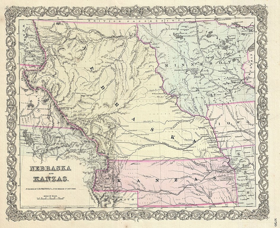
English: A beautiful 1855 first edition example of Colton's map of Nebraska and Kansas. This is most probably the rarest and most desirable of all Colton atlas maps. Based on earlier wall map produced by Colton and D. Griffing Johnson, this map details the regions between the Great Salt Lake and Iowa and between the Canadian Border and New Mexico. Covers territorial Kansas and Nebraska as well as parts of adjacent Minnesota, Iowa, Missouri and Utah. Shows Nebraska in its full territorial glory extending from the 40th parallel to the border British America or Canada. This massive and ephemeral territory covered much of what is today Nebraska, Wyoming, Montana, Colorado, North Dakota and South Dakota. Nearby Minnesota is also exceptionally large embracing all of the territory between Wisconsin and the Missouri River. When this map was printed Nebraska and Kansas had only recently been opened for settlement. Both regions were sparsely inhabited by the diverse yet powerful Indian nations of Comanches, Kioways, Arapahoes, Cheyennes, Sioux, Dacotahs, Poncas, Pawnee's, Omahas, Missouris, Delawares, Shawnee, Osages, Crow, Black, and others - whose territorial claims Colton notes. Colton also notes three of the routes proposed for the Pacific Railroad, the Stevens route far to the north, the Beswith route running through the center of the map, and the Gunnison Route passing through Kansas. This map further identifies various forts, rivers, mountain passes, fords, and an assortment of additional topographical detail. Map is hand colored in pink, green, yellow and blue pastels to define territory and state boundaries. Surrounded by Colton's typical spiral motif border. Dated and copyrighted to J. H. Colton, 1855. Published from Colton's 172 William Street Office in New York City. Issued as page no. 50 in volume 1 of the first edition of George Washington Colton's 1855 Atlas of the World . |
||||||||||||||||||||
| Fecha | 1855 (dated) | ||||||||||||||||||||
| Dimensiones | altura: 13 in (33 cm); ancho: 16 in (40,6 cm) | ||||||||||||||||||||
| Número de inventario |
Geographicus link: NebraskaKansas-colton-1855 |
||||||||||||||||||||
| Fuente/fotógrafo |
Colton, G. W., Colton's Atlas of the World Illustrating Physical and Political Geography, Vol 1, New York, 1855 (First Edition).
|
||||||||||||||||||||
| Permiso (Reutilización de este archivo) |
|
||||||||||||||||||||
| Otras versiones |
_-_Geographicus_-_NebraskaKansas-colton-1855_(edited).jpg) |
||||||||||||||||||||

_-_Geographicus_-_NebraskaKansas-colton-1855.jpg?uselang=es)
Historial del archivo
Haz clic sobre una fecha y hora para ver el archivo tal como apareció en ese momento.
| Fecha y hora | Miniatura | Dimensiones | Usuario | Comentario | |
|---|---|---|---|---|---|
| actual | 02:11 7 abr 2020 | | 4000 × 3251 (3,79 MB) | Tm | Reverted to version as of 11:03, 23 March 2011 (UTC) |
| 23:14 6 abr 2020 |  | 4000 × 3251 (9,02 MB) | Jim Evans | whitened paper & emphasized colors | |
| 11:03 23 mar 2011 |  | 4000 × 3251 (3,79 MB) | BotMultichillT | {{subst:User:Multichill/Geographicus |link=http://www.geographicus.com/P/AntiqueMap/NebraskaKansas-colton-1855 |product_name=1855 Colton Map of Kansas and Nebraska (first edition) |map_title=Nebraska and Kansas. |description=A beautiful 1855 first edition |
Usos del archivo
La siguiente página usa este archivo:
Uso global del archivo
Las wikis siguientes utilizan este archivo:
- Uso en bg.wikipedia.org
- Uso en ca.wikipedia.org
- Uso en en.wikipedia.org
- Uso en fa.wikipedia.org
- Uso en he.wikipedia.org
- Uso en hu.wikipedia.org
- Uso en hy.wikipedia.org
- Uso en it.wikipedia.org
- Uso en la.wikipedia.org
- Uso en mt.wikipedia.org
- Uso en pt.wikipedia.org
- Uso en sh.wikipedia.org
- Uso en simple.wikipedia.org
- Uso en vi.wikipedia.org
- Uso en zh.wikipedia.org
_-_Geographicus_-_NebraskaKansas-colton-1855.jpg)