Archivo:20170805 Bolivia 1214 Sucre sRGB (26204168039).jpg

Ver la imagen en su resolución original (3648 × 2736 píxeles; tamaño de archivo: 2,16 MB; tipo MIME: image/jpeg)
.jpg?uselang=es)
Resumen
| Descripción |
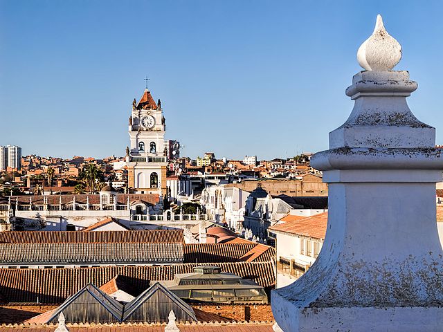
The roof of the Convent of St. Felipe Neri (built in the 17th century and now a museum) provides a panoramic view of the rooftops of Sucre. The tower with the clock in the distance is the bell tower for the Metropolitan Cathedral of Sucre (built between 1559 and 1712 with the clock brought over from London in 1722). Sucre is known as “The White City” because most of the buildings are painted white—and usually have a roof of terracotta tiles. Sucre (elev. 2,810m/9,214ft) was founded by the Spanish in 1538 as Ciudad de la Plata de la Nueva Toledo (Silver City of New Toledo). It became the judicial, religious, and cultural center of the region. Bolivia achieved independence from Spain on 6 August 1825, the last country in Latin America to do so. In 1839 the city was declared the capital of Bolivia and renamed in honor of Antonio José de Sucre (1795-1830), a leader of the fight for independence who was a close friend of Simón Bolívar and served as the second president of Bolivia from the end of 1825 to 1828. (The administrative capital of Bolivia shifted to La Paz in 1898.) The Historic City of Sucre was declared a UNESCO World Heritage Site in 1991. On Google Earth: Convento de San Felipe Neri 19° 3'0.53"S, 65°15'39.91"W Catedral Metropolitana 19° 2'55.48"S, 65°15'35.81"W |
| Fecha | |
| Fuente | 20170805_Bolivia_1214 Sucre sRGB |
| Autor | Dan Lundberg |
| Posición de la cámara | | Ubicación de esta y otras imágenes en: OpenStreetMap |
|---|
.jpg¶ms=-19.049284_N_-065.260462_E_globe:Earth_type:camera_source:Flickr_&language=es)
Licencia
- Eres libre:
- de compartir – de copiar, distribuir y transmitir el trabajo
- de remezclar – de adaptar el trabajo
- Bajo las siguientes condiciones:
- atribución – Debes otorgar el crédito correspondiente, proporcionar un enlace a la licencia e indicar si realizaste algún cambio. Puedes hacerlo de cualquier manera razonable pero no de manera que sugiera que el licenciante te respalda a ti o al uso que hagas del trabajo.
- compartir igual – En caso de mezclar, transformar o modificar este trabajo, deberás distribuir el trabajo resultante bajo la misma licencia o una compatible como el original.
| Esta imagen fue publicada en Flickr por Dan Lundberg en https://flickr.com/photos/9508280@N07/26204168039 (archivo). La imagen fue revisada el 2 de noviembre de 2017 por el robot FlickreviewR 2 y confirmó tener licencia bajo los términos de cc-by-sa-2.0. |
Historial del archivo
Haz clic sobre una fecha y hora para ver el archivo tal como apareció en ese momento.
| Fecha y hora | Miniatura | Dimensiones | Usuario | Comentario | |
|---|---|---|---|---|---|
| actual | 15:58 2 nov 2017 | | 3648 × 2736 (2,16 MB) | Ser Amantio di Nicolao | Transferred from Flickr via Flickr2Commons |
Usos del archivo
Las siguientes páginas usan este archivo:
Uso global del archivo
Las wikis siguientes utilizan este archivo:
- Uso en ar.wikipedia.org
- Uso en ca.wikipedia.org
- Uso en en.wikipedia.org
- Uso en mk.wikipedia.org
- Uso en ml.wikipedia.org
- Uso en ru.wikipedia.org
- Uso en sw.wikipedia.org
- Uso en vi.wikipedia.org
.jpg)