Archivo:Arabia Armistice Mudros.png

Ver la imagen en su resolución original (3242 × 3572 píxeles; tamaño de archivo: 1,12 MB; tipo MIME: image/png)
Resumen
| Descripción |
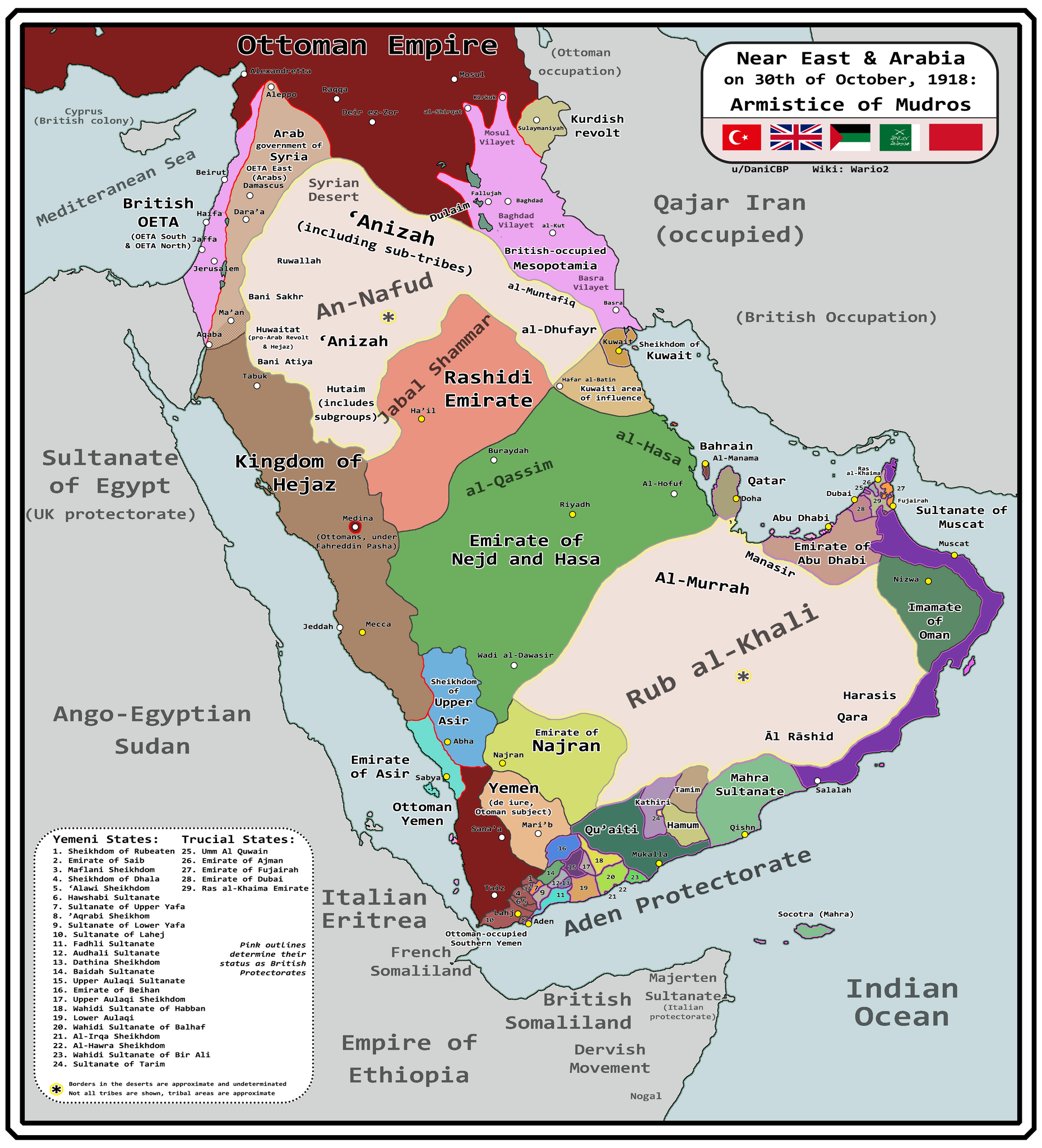
English: Map of Arabia and the Near East at the end of World War I, in October 30th, 1918, day of the Armistice of Mudros. |
| Fecha | |
| Fuente |
Trabajo propio + Ashkenazi, T. (1948). The ’Anazah Tribes. Southwestern Journal of Anthropology, 4(2), 222–239. http://www.jstor.org/stable/3628713 H. St. J. B. Philby. (1920). Southern Najd. The Geographical Journal, 55(3), 161–185. https://doi.org/10.2307/1781600 Haines, S. B. (1839). Memoir, to Accompany a Chart of the South Coast of Arabia from the Entrance of the Red Sea to Misenát, in 50° 43′ 25″ E. The Journal of the Royal Geographical Society of London, 9, 125–156. https://doi.org/10.2307/1797718 Helfritz, H. (1935). The First Crossing of Southwestern Arabia. Geographical Review, 25(3), 395–407. https://doi.org/10.2307/209308 Thomas, B. (1929). Among Some Unknown Tribes of South Arabia. The Journal of the Royal Anthropological Institute of Great Britain and Ireland, 59, 97–111. https://doi.org/10.2307/2843560 Anderson, S. (2014). Lawrence in Arabia: War, Deceit, Imperial Folly and the Making of the Modern Middle East. Atlantic Books Ltd. Boxberger, L. (2012). On the Edge of Empire: Hadhramawt, Emigration, and the Indian Ocean, 1880s–1930s. SUNY Press. J. E. Peterson. (1976) "The Revival of the Ibadi Imamate in Oman and the Threat to Muscat, 1913–20," Arabian Studies 3 Al-Maghafi, Fadhl (2012). "MORE THAN JUST A BOUNDARY DISPUTE: THE REGIONAL GEOPOLITICS OF SAUDI-YEMENI RELATIONS" (PDF). eprints.soas.ac.uk Bang, Anne (1997). The Idrisi State in Asir 1906–1934. Hurst Publishers. pp. 111–114. ISBN 9781850653066. Eskander, S. "Britain's Policy Towards The Kurdish Question, 1915-1923" (PDF). etheses.lse.ac.uk. |
| Autor | Wario2 |
Licencia
- Eres libre:
- de compartir – de copiar, distribuir y transmitir el trabajo
- de remezclar – de adaptar el trabajo
- Bajo las siguientes condiciones:
- atribución – Debes otorgar el crédito correspondiente, proporcionar un enlace a la licencia e indicar si realizaste algún cambio. Puedes hacerlo de cualquier manera razonable pero no de manera que sugiera que el licenciante te respalda a ti o al uso que hagas del trabajo.
Historial del archivo
Haz clic sobre una fecha y hora para ver el archivo tal como apareció en ese momento.
| Fecha y hora | Miniatura | Dimensiones | Usuario | Comentario | |
|---|---|---|---|---|---|
| actual | 10:18 13 mar 2024 | | 3242 × 3572 (1,12 MB) | Wario2 | Uploaded own work with UploadWizard |
Usos del archivo
Las siguientes páginas usan este archivo:
Uso global del archivo
Las wikis siguientes utilizan este archivo:
- Uso en en.wikipedia.org
- Uso en mt.wikipedia.org