Archivo:Beaver wars map.jpg

Tamaño de esta previsualización: 710 × 600 píxeles. Otras resoluciones: 284 × 240 píxeles · 568 × 480 píxeles · 871 × 736 píxeles.
Ver la imagen en su resolución original (871 × 736 píxeles; tamaño de archivo: 163 kB; tipo MIME: image/jpeg)
| Descripción |
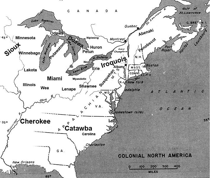
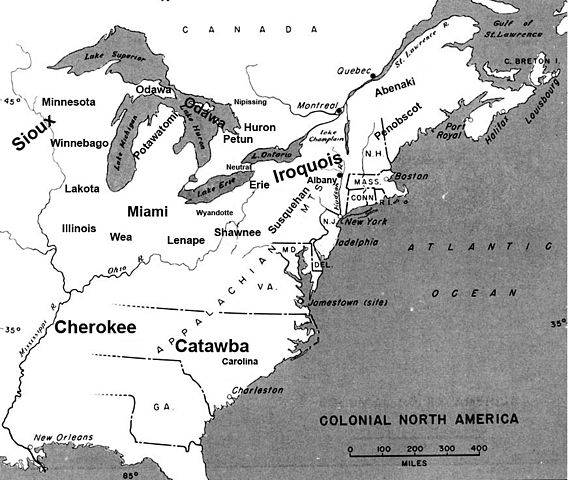
English: Map of the location of major tribes involved in the Beaver Wars laid against a period map showing colonial settlments |
||
| Fecha | |||
| Fuente | Trabajo propio | ||
| Autor | Charles Edward | ||
| Permiso (Reutilización de este archivo) |
|
Info
This represents the approximate configuration of the tribes in 1648. Although the areas are large, the populations were low and large parts of the territories where uninhabited, and instead used as hunting grounds. The tribes were also semi nomadic, and the period was rife with war and several of the tribes on the map were destroyed in the 1650s. The map was made using information in several books incluing:
- Jennings, Francis (1984) The Ambiguous Iroquois Empire ISBN: 0393017192.
- Wallace, Paula W (2007) Indians in Pennsylvania, DIANE Publishing Inc ISBN: 1422314936.
Historial del archivo
Haz clic sobre una fecha y hora para ver el archivo tal como apareció en ese momento.
| Fecha y hora | Miniatura | Dimensiones | Usuario | Comentario | |
|---|---|---|---|---|---|
| actual | 22:34 18 nov 2008 | | 871 × 736 (163 kB) | Charles Edward | Slight adjustment to name on image |
| 22:33 18 nov 2008 |  | 871 × 736 (164 kB) | Charles Edward | {{Information |Description=adjustment of locations per discussion on Beaver War talk page |Source= |Date= |Author= |Permission= |other_versions= }} | |
| 19:51 16 nov 2008 |  | 871 × 736 (298 kB) | Charles Edward | {{Information |Description=New version removes borders, ads more ambiguity to the map |Source= |Date= |Author= |Permission= |other_versions= }} | |
| 02:43 16 nov 2008 |  | 815 × 472 (275 kB) | Charles Edward | {{Information |Description= |Source= |Date= |Author= |Permission= |other_versions= }} | |
| 01:16 16 nov 2008 |  | 815 × 472 (275 kB) | Charles Edward | {{Information |Description=adding tribes, adjusting locations |Source= |Date= |Author= |Permission= |other_versions= }} Category:Maps of the United States | |
| 00:39 16 nov 2008 |  | 815 × 472 (270 kB) | Charles Edward | {{Information |Description=Added additional tribes |Source= |Date= |Author= |Permission= |other_versions= }} | |
| 00:35 16 nov 2008 |  | 815 × 472 (270 kB) | Charles Edward | {{Information |Description=Added additional tribes |Source= |Date= |Author= |Permission= |other_versions= }} | |
| 00:14 16 nov 2008 |  | 815 × 472 (262 kB) | Charles Edward | {{Information |Description={{en|1=Map of the location of major tribes involved in the Beaver Wars laid against a period map showing colonial settlments}} |Source=Own work by uploader |Author=Charles Edward |Date=11-15-8 |Permission |
Usos del archivo
La siguiente página usa este archivo:
Uso global del archivo
Las wikis siguientes utilizan este archivo:
- Uso en azb.wikipedia.org
- Uso en cs.wikipedia.org
- Uso en en.wikipedia.org
- Uso en et.wikipedia.org
- Uso en gl.wikipedia.org
- Uso en id.wikipedia.org
- Uso en it.wikipedia.org
- Uso en ja.wikipedia.org
- Uso en lv.wikipedia.org
- Uso en nl.wikipedia.org
- Uso en no.wikipedia.org
- Uso en pl.wikipedia.org