Archivo:Champaner, Kevada Masjid (9840302206).jpg
Ver la imagen en su resolución original (5184 × 3456 píxeles; tamaño de archivo: 6,54 MB; tipo MIME: image/jpeg)
.jpg?uselang=es)
Resumen
| Descripción |
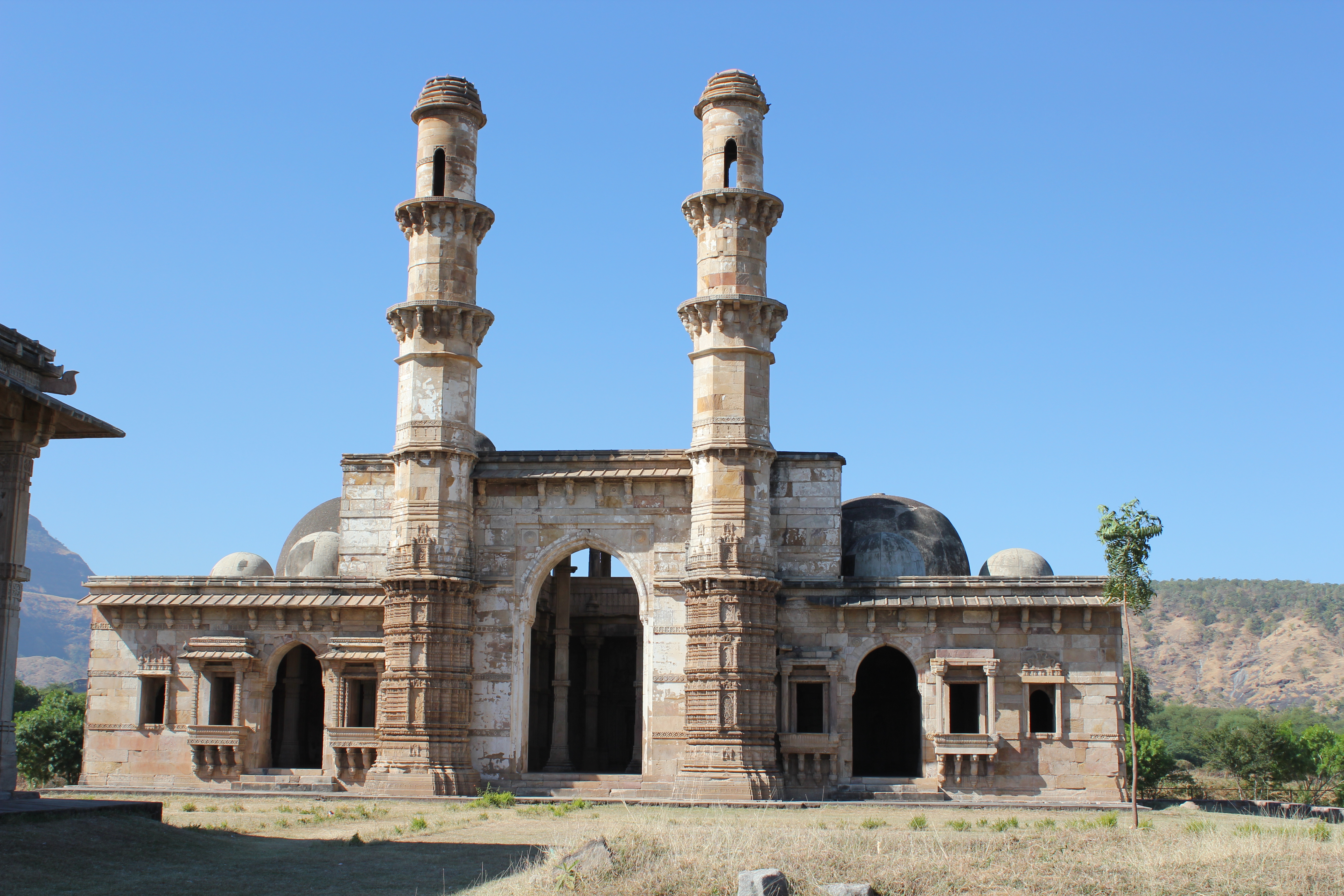
Champaner, Kevada Masjid Champaner, also known as Muhammadabad, is a historical city in the state of Gujarat, in western India. The city was briefly the capital of Gujarat. It was founded by Vanraj Chavda, the most prominent king of the Chavda Dynasty, in the 8th century. He named it after the name of his friend and general Champa, also known later as Champaraj. By the later 15th century, the Khichi Chauhan Rajputs held Pavagadh fort above the town of Champaner. The young Sultan of Gujarat, Mahmud Begada, deciding to attack Champaner, started towards it with his army on 4 December 1482. After defeating the Champaner army, Mahmud captured the town and besieged Pavagadh, the well-known hill-fortress, above Champaner, where king Jayasimha had taken refuge. He captured the Pavagadh fort on 21 November 1484, after a siege of 20 months. He then spent 23 years rebuilding and embellishing Champaner, which he renamed Muhammadabad, after which he moved the capital there from Ahmedabad. In 1535, after chasing away Bahadur Shah, Humayun personally led some 300 Mughals to scale the fort on spikes driven into rock and stonework in a remote and unguarded part of the citadel built over a precipitous hillside on Pavagadh Hill. Large heaps of gold, silver and jewels were the war booty even though Bahadur Shah had managed to escape to Diu. Champaner is today the site of the Champaner-Pavagadh Archaeological Park, which UNESCO designated a World Heritage Site in 2004. There are eleven different types of buildings at the UNESCO-protected Champaner-Pavagadh Archaeological Park, including mosques, temples, granaries, tombs, wells, walls, and terraces. The monuments are situated at the foot of and around the Pavagadh Hill. The Baroda Heritage Trust lists 114 monuments in the area, of which only 39 are maintained by the Archeological Survey of India, due to limited funding. Kevada Masjid (also Kewda or Kevda) has minarets, globe-like domes, and narrow stairs. This mosque was built in Champaner during the time of Mahmud Begada, as were several other masjids, such as the Bawaman, Ek Minar, Jama, Khajuri, Nagina, and Shahar Ki. The Kevada is notable because of its mausoleum. The masjid has many mehrabs, all intricately carved. There is a damaged brick tank for ablutions before prayers are offered at the mosque. The cenotaph is square in shape with a fluted central dome and four corner domes; it is located next to the tank. The layout of the masjid is rectangular. Floral and geometrical designs adorn the niches. The tribate inter-columns are considered attractive. The prayer hall, a double storied structure, had three domes but the central dome has since disappeared. The windows have balconies built over pillars with intricate carved decorations. There are two minarets, which are also decorated with intricate carvings. (source: en.wikipedia.org/wiki/Champaner, en.wikipedia.org/wiki/Monuments_of_Champaner-Pavagadh_Arc..., and en.wikipedia.org/wiki/Kevada_Masjid,_Champaner) |
| Fecha | |
| Fuente | Champaner, Kevada Masjid |
| Autor | Arian Zwegers from Brussels, Belgium |
| Posición de la cámara | | Ubicación de esta y otras imágenes en: OpenStreetMap |
|---|
.jpg¶ms=022.489358_N_0073.533769_E_globe:Earth_type:camera_source:Flickr_&language=es)
Licencia
- Eres libre:
- de compartir – de copiar, distribuir y transmitir el trabajo
- de remezclar – de adaptar el trabajo
- Bajo las siguientes condiciones:
- atribución – Debes otorgar el crédito correspondiente, proporcionar un enlace a la licencia e indicar si realizaste algún cambio. Puedes hacerlo de cualquier manera razonable pero no de manera que sugiera que el licenciante te respalda a ti o al uso que hagas del trabajo.
| Esta imagen fue publicada en Flickr por Arian Zwegers en https://flickr.com/photos/67769030@N07/9840302206. La imagen fue revisada el 8 de marzo de 2016 por el robot FlickreviewR y confirmó tener licencia bajo los términos de cc-by-2.0. |
Historial del archivo
Haz clic sobre una fecha y hora para ver el archivo tal como apareció en ese momento.
| Fecha y hora | Miniatura | Dimensiones | Usuario | Comentario | |
|---|---|---|---|---|---|
| actual | 20:08 8 mar 2016 | | 5184 × 3456 (6,54 MB) | Shipjustgotreal | Transferred from Flickr via Flickr2Commons |
Usos del archivo
La siguiente página usa este archivo:
Uso global del archivo
Las wikis siguientes utilizan este archivo:
- Uso en en.wikipedia.org
- Uso en en.wikivoyage.org
- Uso en www.wikidata.org
.jpg)