Archivo:Chile's salt flat ESA360999.jpg

Ver la imagen en su resolución original (5000 × 5000 píxeles; tamaño de archivo: 27,36 MB; tipo MIME: image/jpeg)
Resumen
| Descripción |
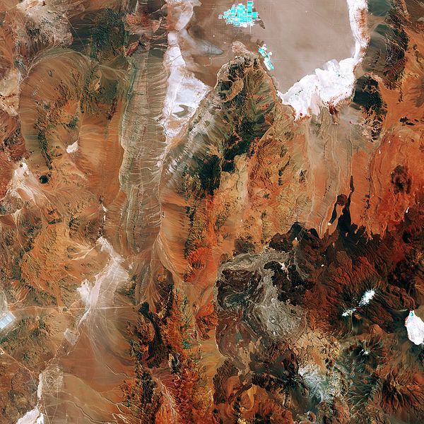
English: The Sentinel-2A satellite takes us to the diverse landscape of the eastern Atacama desert in South America. The region pictured lies around 200km east of the Chilean city of Antofagasta on the Pacific coast (not pictured), and is virtually devoid of vegetation.
At the top of the image we can see part of Chile’s largest salt flat, the Salar de Atacama. With an average elevation of some 2300 m above sea level, it is formed by waters flowing down from the Andes, which, having no drainage outlets, are forced to evaporate, leaving salt deposits. It is the world’s largest and purest active source of lithium, containing some 30% of the world's lithium reserve base, and providing almost 30% of the world’s lithium carbonate supply. The bright turquoise rectangles and squares visible along the top part of the image are evaporation ponds. Subsurface salt brines are pumped from beneath the saline crust in two different areas. In one of them, extracted salt brines have unrivalled concentration levels of potassium and lithium. In the other, the brines obtained contain high concentrations of sulphate and boron. In the lower right part of the image we can see the Socompa stratovolcano, known for its ‘debris avalanche deposit’ where the land collapsed on its western rim some 7000 years ago. The area has since been partially filled by lava, and we can see dark lava flows around the volcano. The multispectral instrument on Sentinel-2 uses parts of the infrared spectrum to analyse mineral composition where vegetation is sporadic. In this false-colour image, the intense shades of brown and orange come from the use of an infrared part of the spectrum leading to an exaggeration of colour intensity. This image – also featured on theEarth from Space video programme– was captured by Sentinel-2A on 8 March. The satellite is the first in the twin satellite Sentinel-2 mission for Europe’s Copernicus programme, and carries a wide-swath high-resolution multispectral imager with 13 spectral bands, for a new angle on our land and vegetation. |
| Fecha | |
| Fuente | http://www.esa.int/spaceinimages/Images/2016/05/Chile_s_salt_flat |
| Autor | European Space Agency |
| Permiso (Reutilización de este archivo) |
Contains modified Copernicus Sentinel data [2016], processed by ESA,CC BY-SA 3.0 IGO |
| Otras versiones |
|
| Title | Chile's salt flat |
| Location | Chile |
| Keywords | Deserts |
| Set | Earth observation image of the week |
| Mission | Sentinel-2 |
| Activity | Observing the Earth |

Licencia
This media was created by the European Space Agency (ESA).
Where expressly so stated, images or videos are covered by the Creative Commons Attribution-ShareAlike 3.0 IGO (CC BY-SA 3.0 IGO) licence, ESA being an Intergovernmental Organisation (IGO), as defined by the CC BY-SA 3.0 IGO licence. The user is allowed under the terms and conditions of the CC BY-SA 3.0 IGO license to Reproduce, Distribute and Publicly Perform the ESA images and videos released under CC BY-SA 3.0 IGO licence and the Adaptations thereof, without further explicit permission being necessary, for as long as the user complies with the conditions and restrictions set forth in the CC BY-SA 3.0 IGO licence, these including that:
See the ESA Creative Commons copyright notice for complete information, and this article for additional details.
|
 | |
Este archivo se encuentra bajo la licencia Creative Commons Atribución Compartir-Igual 3.0 IGO. Atribución: ESA, CC BY-SA IGO 3.0
| ||

|
Esta imagen contiene datos que provienen de un satélite del Programa Copérnico, como Sentinel-1, Sentinel 2 o Sentinel-3. Se require atribución cuando se utilice esta imagen.
Atribución: Contiene datos modificados de Copernicus Sentinel 2016
El uso de datos Sentinel del Programa Cópernico está regulado por la legislación europea: Reglamento Delegado (UE) No 1159/2013 de la Comisión y el Reglamento (UE) No 377/2014. Los pasajes relevantes son:
Se permitirá el acceso gratuito a los datos dedicados del GMES y a la información de servicio del GMES a través de las plataformas de difusión del GMES [...].
Se dará acceso a los datos dedicados del GMES y a la información de servicio del GMES a los efectos que se detallan a continuación, siempre y cuando sean lícitos:
Los datos dedicados del GMES y la información de servicio del GMES podrán utilizarse en todo el mundo sin limitación de tiempo.
Los datos dedicados del GMES y la información de servicio del GMES se facilitarán a los usuarios sin ninguna garantía explícita o implícita, incluyendo lo tocante a la calidad y la idoneidad para cualesquiera fines. |
Historial del archivo
Haz clic sobre una fecha y hora para ver el archivo tal como apareció en ese momento.
| Fecha y hora | Miniatura | Dimensiones | Usuario | Comentario | |
|---|---|---|---|---|---|
| actual | 17:32 12 may 2017 | | 5000 × 5000 (27,36 MB) | Yann | c:User:Rillke/bigChunkedUpload.js: HR from TIFF, 98% compression |
| 13:03 7 may 2017 |  | 1920 × 1920 (5,03 MB) | Fæ | European Space Agency, Id 360999, http://www.esa.int/spaceinimages/Images/2016/05/Chile_s_salt_flat, User:Fæ/Project_list/ESA |
Usos del archivo
La siguiente página usa este archivo:
Uso global del archivo
Las wikis siguientes utilizan este archivo:
- Uso en en.wikipedia.org