Archivo:China 1936.png
No se dispone de una resolución más alta.
China_1936.png (120 × 131 píxeles; tamaño de archivo: 13 kB; tipo MIME: image/png)
Resumen
| Descripción |
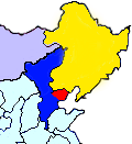
English: This map shows the territory controlled by the Hebei-Chahar Political Council (blue), the East Hebei Anti-Communist Autonomous Government (red), Manchukuo (yellow), and Mongolia (grey) at the end of 1935 and the beginning of 1936. As noted on Wikipedia, the Hebei-Chahar Political Council controlled the provinces of Chahar and Hebei except for the portion of Hebei Province occuped by the East Hebei Anti-Communist Autonomous Government, which, as noted by Paul French in The Old Shanghai A-Z and other sources, controlled the 22 northeastern counties of Hebei Province running along the Great Wall and south into the demilitarized zone almost as far south as Beijing and Tianjin.
Although this is a crude map based off "File:ROC-Chahar.png", there are several articles in severe need of some sort of geographic illustration, |
| Fecha | |
| Fuente | Trabajo propio |
| Autor | CurtisNaito |
Licencia
Yo, el titular de los derechos de autor de esta obra, la publico en los términos de la siguiente licencia:
Este archivo se encuentra bajo la licencia Creative Commons Genérica de Atribución/Compartir-Igual 3.0.
- Eres libre:
- de compartir – de copiar, distribuir y transmitir el trabajo
- de remezclar – de adaptar el trabajo
- Bajo las siguientes condiciones:
- atribución – Debes otorgar el crédito correspondiente, proporcionar un enlace a la licencia e indicar si realizaste algún cambio. Puedes hacerlo de cualquier manera razonable pero no de manera que sugiera que el licenciante te respalda a ti o al uso que hagas del trabajo.
- compartir igual – En caso de mezclar, transformar o modificar este trabajo, deberás distribuir el trabajo resultante bajo la misma licencia o una compatible como el original.
Historial del archivo
Haz clic sobre una fecha y hora para ver el archivo tal como apareció en ese momento.
| Fecha y hora | Miniatura | Dimensiones | Usuario | Comentario | |
|---|---|---|---|---|---|
| actual | 23:27 18 oct 2012 | | 120 × 131 (13 kB) | CurtisNaito | User created page with UploadWizard |
Usos del archivo
Las siguientes páginas usan este archivo:
Uso global del archivo
Las wikis siguientes utilizan este archivo:
- Uso en en.wikipedia.org
- Uso en ja.wikipedia.org
- Uso en nl.wikipedia.org
- Uso en uk.wikipedia.org
- Uso en www.wikidata.org
- Uso en zh.wikipedia.org