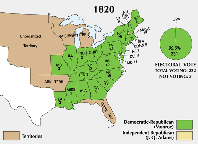
Archivo:ElectoralCollege1820-Large.png

Tamaño de esta previsualización: 800 × 585 píxeles. Otras resoluciones: 320 × 234 píxeles · 640 × 468 píxeles · 867 × 634 píxeles.
Ver la imagen en su resolución original (867 × 634 píxeles; tamaño de archivo: 69 kB; tipo MIME: image/png)
| U.S. presidential election maps from the National Atlas of the United States |
| See also: SVG maps |
| 1789 · 1792 · 1796 · 1800 · 1804 · 1808 · 1812 · 1816 · 1820 · 1824 · 1828 · 1832 · 1836 · 1840 · 1844 · 1848 · 1852 · 1856 · 1860 · 1864 · 1868 · 1872 · 1876 · 1880 · 1884 · 1888 · 1892 · 1896 · 1900 · 1904 · 1908 · 1912 · 1916 · 1920 · 1924 · 1928 · 1932 · 1936 · 1940 · 1944 · 1948 · 1952 · 1956 · 1960 · 1964 · 1968 · 1972 · 1976 · 1980 · 1984 · 1988 · 1992 · 1996 · 2000 · 2004 |
Resumen
| Descripción | |
| Fuente | https://nationalmap.gov/small_scale/printable/elections.html |
| Autor | Servicio Geológico de los Estados Unidos |
Licencia
This map was obtained from an edition of the National Atlas of the United States. Like almost all works of the U.S. federal government, works from the National Atlas are in the public domain in the United States.
Online access: NationalAtlas.gov | 1970 print edition: Library of Congress, Perry-Castañeda Library
|
Historial del archivo
Haz clic sobre una fecha y hora para ver el archivo tal como apareció en ese momento.
| Fecha y hora | Miniatura | Dimensiones | Usuario | Comentario | |
|---|---|---|---|---|---|
| actual | 17:59 22 ene 2006 | | 867 × 634 (69 kB) | Red devil 666 | {{PD-USGov-Atlas}} |
Usos del archivo
No hay páginas que enlacen a este archivo.
Uso global del archivo
Las wikis siguientes utilizan este archivo:
- Uso en en.wikipedia.org
- Uso en nl.wikipedia.org
- Uso en uk.wikipedia.org
- Uso en vi.wikipedia.org