Archivo:Eu cartogram.png
No se dispone de una resolución más alta.
Eu_cartogram.png (490 × 436 píxeles; tamaño de archivo: 10 kB; tipo MIME: image/png)
Resumen
| Descripción |
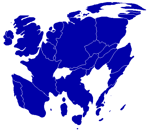
English: A cartogram depicting population distribution within the European Union at the member state level. Note how roughly half of all citizens within the EU live within the 4 largest member states: Germany, France, United Kingdom, and Italy. |
| Fecha | |
| Fuente | Self-made, referenced from a similiar cartogram at worldmapper.net |
| Autor | Geoilex |
Licencia
| Yo, el titular de los derechos de autor de esta obra, lo libero al dominio público. Esto aplica en todo el mundo. En algunos países esto puede no ser legalmente factible; si ello ocurriese: Concedo a cualquier persona el derecho de usar este trabajo para cualquier propósito, sin ningún tipo de condición al menos que éstas sean requeridas por la ley. |
Historial del archivo
Haz clic sobre una fecha y hora para ver el archivo tal como apareció en ese momento.
| Fecha y hora | Miniatura | Dimensiones | Usuario | Comentario | |
|---|---|---|---|---|---|
| actual | 09:54 27 mar 2008 | | 490 × 436 (10 kB) | Geoilex | {{Information |Description= A cartogram depicting population distribution within the European Union at the member state level. Note how roughly half of all citizens within the EU live within the 4 largest member states: Germany, France, United Kingdom, an |
| 09:47 27 mar 2008 |  | 490 × 436 (10 kB) | Geoilex | {{Information |Description= A cartogram depicting population distribution within the European Union and the member state level. Note how roughly half of all citizens within the EU live within the 4 largest member states: Germany, France, United Kingdom, a |
Usos del archivo
La siguiente página usa este archivo:
Uso global del archivo
Las wikis siguientes utilizan este archivo:
- Uso en cs.wikipedia.org
- Uso en en.wikipedia.org
- Uso en fr.wikipedia.org
- Uso en gl.wikipedia.org
- Uso en he.wikipedia.org
- Uso en it.wikipedia.org
- Uso en it.wikibooks.org
- Uso en nl.wikipedia.org
- Uso en pt.wikipedia.org
- Uso en sv.wikipedia.org
- Uso en uk.wikipedia.org