Archivo:European Union OCTs Locator.png

Tamaño de esta previsualización: 800 × 383 píxeles. Otras resoluciones: 320 × 153 píxeles · 640 × 306 píxeles · 1024 × 490 píxeles · 1280 × 612 píxeles · 2420 × 1158 píxeles.
Ver la imagen en su resolución original (2420 × 1158 píxeles; tamaño de archivo: 165 kB; tipo MIME: image/png)

|
File:EU EEZ.svg es una versión vectorial de este archivo. Debería usarse esa versión en lugar de este archivo PNG, cuando sea mejor.
File:European Union OCTs Locator.png → File:EU EEZ.svg
Para más información, lee Ayuda:SVG. |
 |
Resumen
| Descripción |
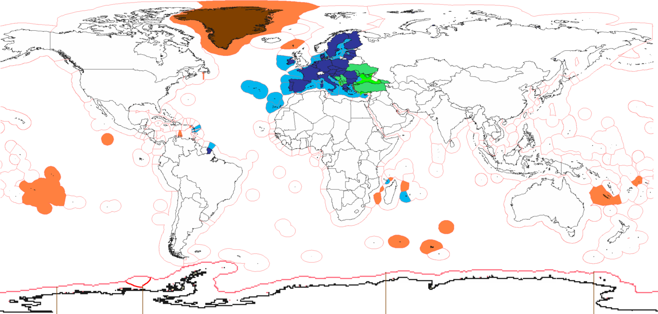
English: EU
enlargement agenda
member state special territories outside EU |
| Fecha | |
| Fuente | Trabajo propio (Texto original: «I (Alinor (talk)) created this work entirely by myself.») |
| Autor | Alinor de Wikipedia en inglés |

|
Esta imagen debería volverse a crear como imágenes vectoriales SVG. Esto proporciona muchas ventajas, véase Commons:Media for cleanup (en inglés) para más información. Si ya hay una versión SVG de esta imagen disponible, por favor súbala a Commons. Tras subirla, reemplace esta plantilla con la plantilla
{{vector version available|nuevo nombre de imagen.svg}} en esta imagen. |
Licencia
Alinor de Wikipedia en inglés, titular de los derechos de autor de esta obra, la publica en los términos de las siguientes licencias:
Este archivo se encuentra bajo la licencia Creative Commons Genérica de Atribución/Compartir-Igual 3.0.
Atribución: Alinor de Wikipedia en inglés
- Eres libre:
- de compartir – de copiar, distribuir y transmitir el trabajo
- de remezclar – de adaptar el trabajo
- Bajo las siguientes condiciones:
- atribución – Debes otorgar el crédito correspondiente, proporcionar un enlace a la licencia e indicar si realizaste algún cambio. Puedes hacerlo de cualquier manera razonable pero no de manera que sugiera que el licenciante te respalda a ti o al uso que hagas del trabajo.
- compartir igual – En caso de mezclar, transformar o modificar este trabajo, deberás distribuir el trabajo resultante bajo la misma licencia o una compatible como el original.

|
Se autoriza la copia, distribución y modificación de este documento bajo los términos de la licencia de documentación libre GNU, versión 1.2 o cualquier otra que posteriormente publique la Fundación para el Software Libre; sin secciones invariables, textos de portada, ni textos de contraportada. Se incluye una copia de la dicha licencia en la sección titulada Licencia de Documentación Libre GNU. |
Puedes usar la licencia que prefieras.
Registro original de carga
Transferido desde en.wikipedia a Commons por SreeBot.
Aquí se muestra la página de descripción original. Los siguientes nombres de usuario se refieren a en.wikipedia.
Upload date | User | Bytes | Dimensions | Comment
- 2010-12-24 09:10 (UTC) | Alinor | 206750 (bytes) | 2420×1292 | see talk
- 2010-10-31 06:57 (UTC) | Alinor | 206759 (bytes) | 2420×1292 | CH fix
- 2010-07-22 15:45 (UTC) | Alinor | 206778 (bytes) | 2420×1292 | {{Information |Description = blue-EU, green-enlargement agenda, orange-EU member state special territories outside EU |Source = I (~~~) created this work entirely by myself. |Date = ~~~~~ |Author = ~~~ |other_versions =
Historial del archivo
Haz clic sobre una fecha y hora para ver el archivo tal como apareció en ese momento.
| Fecha y hora | Miniatura | Dimensiones | Usuario | Comentario | |
|---|---|---|---|---|---|
| actual | 15:41 2 jul 2022 | | 2420 × 1158 (165 kB) | Salvan Lorand | Ukraine, Moldova and Georgia are all 3 on the enlargement agenda now, Moldova and Ukraine har already receiverd candidate status too |
| 15:39 2 feb 2020 |  | 2420 × 1158 (165 kB) | Heitordp | Removed UK, British territories and Iceland; adjusted Cyprus, Switzerland and Clipperton; reduced white space on top | |
| 22:23 15 jun 2019 |  | 2420 × 1292 (115 kB) | Jurryaany | Minor fixes, removed Northern Cyprus from pending status and colored Mayotte blue as it is a full member territory | |
| 12:09 5 ene 2016 |  | 2420 × 1292 (167 kB) | Chocofrito | According to the Antarctic Treaty, no country can have any territory in Antarctica. | |
| 11:22 30 jun 2013 |  | 2420 × 1292 (225 kB) | U5K0 | croatia | |
| 10:47 16 nov 2011 |  | 2420 × 1292 (202 kB) | SreeBot | (Original text) : see talk | |
| 10:46 16 nov 2011 |  | 2420 × 1292 (202 kB) | SreeBot | (Original text) : CH fix | |
| 10:46 16 nov 2011 |  | 2420 × 1292 (202 kB) | SreeBot | (Original text) : {{Information |Description = blue-EU, green-enlargement agenda, orange-EU member state special territories outside EU |Source = I (~~~) created this work entirely by myself. |Date = ~~~~~ |Author = ~~~ | |
Usos del archivo
No hay páginas que enlacen a este archivo.
Uso global del archivo
Las wikis siguientes utilizan este archivo:
- Uso en el.wikipedia.org
- Uso en en.wikipedia.org
- Uso en it.wikipedia.org
- Uso en sl.wikipedia.org
- Uso en uk.wikipedia.org