Archivo:Floridakeys-nasa.jpg
Ver la imagen en su resolución original(1400 × 1000 píxeles; tamaño de archivo: 215 kB; tipo MIME: image/jpeg)

Resumen

Descripción
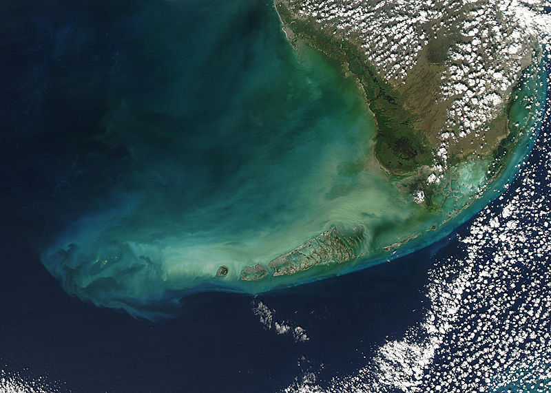
English: Turbid waters surround southern Florida and the Florida Keys in this true-color Moderate Resolution Imaging Spectroradiometer (MODIS) image taken by the Aqua satellite on December 2, 2003. Clouds of milky blue, green, and tan sediments and microscopic marine organisms (like phytoplankton and algae) discolor the water in the Gulf of Mexico north of the Keys, but end abruptly in the deeper water of the Straits of Florida. The water north of the Keys is relatively shallow, so sediments are a likely cause of the discoloration—rough waters can churn up the mud from the sea floor, which then clouds the water. But in the deeper water south of the Keys, sediment on the sea floor is much harder to disturb, which keeps the water clearer.

The Keys are a collection of islands, islets, and reefs stretching from Virginia Key to the Dry Tortugas, a distance of about 309 kilometers (192 miles). They're made mostly of limestone and coral, and are known for their variety of wildlife, subtropical vegetation, and spectacular diving. Most of the islands are connected to the mainland via the Overseas Highway, making this a popular and easily-accessible destination.

However, popularity can be a double-edged sword. On the one hand, tourism is one of the economic mainstays of the region, and helps increase public awareness of how fragile this ecosystem is. But on the other hand, those same tourists and their activities can hurt the ecosystem by introducing pollutants and causing physical damage to fragile reefs.
Fecha
Fuente www.nasa.gov
Autor Jeff Schmaltz, MODIS Rapid Response Team, NASA/GSFC

Licencia

Public domain Este archivo es de dominio público porque fue creado por la NASA. Las políticas sobre copyright de la NASA estipulan que «el material de la NASA no está protegido con copyright a menos que se indique lo contrario». (Políticas sobre copyright de la NASA o Políticas sobre la utilización de imágenes del Jet Propulsion Laboratory).
Advertencias:
  • El uso del logotipo de la NASA (incluidos el logotipo actual y los anteriores) está restringido.
  • El sitio web de la NASA almacena una gran cantidad de imágenes del Programa Espacial de la URSS, de la Agencia Espacial Federal Rusa y otras agencias espaciales no estadounidenses. Estas imágenes no son de dominio público.
  • Material del Telescopio espacial Hubble puede tener copyright si no proviene explícitamente del Space Telescope Science Institute. [1]
  • Todo el material creado por la sonda espacial SOHO está protegido por copyright y requiere permiso para ser utilizado con fines comerciales o no educativos. [2]
  • Las imágenes que figuran en el sitio web Astronomy Picture of the Day (APOD) pueden tener copyright. [3]

Leyendas

Añade una explicación corta acerca de lo que representa este archivo

Elementos representados en este archivo

representa a

Historial del archivo

Haz clic sobre una fecha y hora para ver el archivo tal como apareció en ese momento.

Fecha y horaMiniaturaDimensionesUsuarioComentario
actual21:59 23 ago 2005Miniatura de la versión del 21:59 23 ago 20051400 × 1000 (215 kB)Nanosmile * Credit Jeff Schmaltz, MODIS Rapid Response Team, NASA/GSFC Turbid waters surround southern Florida and the Florida Keys in this true-color Moderate Resolution Imaging Spectroradiometer (MODIS) image taken by the Aqua satellite on Dece

La siguiente página usa este archivo:

Uso global del archivo

Las wikis siguientes utilizan este archivo:

Metadatos