Archivo:Furukawa-Numa marsh Aerial Photograph.jpg

Tamaño de esta previsualización: 800 × 598 píxeles. Otras resoluciones: 320 × 239 píxeles · 640 × 478 píxeles · 1024 × 765 píxeles · 1225 × 915 píxeles.
Ver la imagen en su resolución original (1225 × 915 píxeles; tamaño de archivo: 278 kB; tipo MIME: image/jpeg)
Resumen
| Descripción |
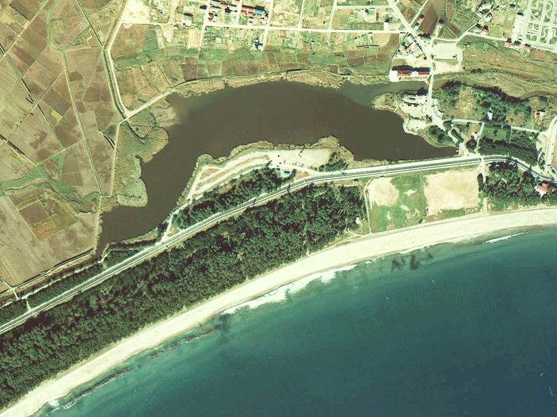
English: Aerial view of Furukawa numa (Furukawa marsh) in Rikuzentakata City, Iwate Prefecture, Japan. The marsh disappeared by the tsunami caused by the East Japan Great Earthquake in 2011
日本語: 2011年の東日本大震災による津波で消滅する前の岩手県陸前高田市・古川沼の空中写真(1977年撮影)。cto-77-8_c20c_3を利用 |
| Fecha | |
| Fuente |
English: National Land Image Information (Color Aerial Photographs) 日本語: 国土画像情報(カラー空中写真) |
| Autor |
English: Ministry of Land, Infrastructure, Transport and Tourism of Japan 日本語: 国土交通省 |
Licencia

|
El propietario de los derechos de autor de este archivo, the Ministry of Land, Infrastructure, Transport and Tourism of Japan, autoriza a cualquier persona a usarlo para cualquier propósito, siempre que el titular de los derechos de autor sea atribuido apropiadamente. La redistribución, la realización de trabajos derivados, el uso comercial y otro tipo de usos están permitidos. |
Atribución:
Copyright © National Land Image Information (Color Aerial Photographs), Ministry of Land, Infrastructure, Transport and Tourism
|
 |
This image is copyrighted by the Ministry of Land, Infrastructure, Transport and Tourism of Japan. For terms of use, see the stipulation to use of National Land Information (in Japanese) and message from MLIT (in Japanese and English). When you display this image on an article, include the following phrase in the description: "Made based on National Land Image Information (Color Aerial Photographs), Ministry of Land, Infrastructure, Transport and Tourism".
|
Historial del archivo
Haz clic sobre una fecha y hora para ver el archivo tal como apareció en ese momento.
| Fecha y hora | Miniatura | Dimensiones | Usuario | Comentario | |
|---|---|---|---|---|---|
| actual | 08:16 12 ago 2011 | | 1225 × 915 (278 kB) | さかおり | {{Information |Description ={{en|1=Aerial view of marsh disappear by the tsunami earlier Furukawa}} {{ja|1=津波で消滅する前(1977年撮影)の古川沼(岩手県陸前高田市)空中写真。cto-77-8_c20c_3を利用。}} |Source |
Usos del archivo
La siguiente página usa este archivo:
Uso global del archivo
Las wikis siguientes utilizan este archivo:
- Uso en de.wikipedia.org
- Uso en en.wikipedia.org
- Uso en ja.wikipedia.org
- Uso en pt.wikipedia.org