Archivo:Hanstholmen-map.png

Ver la imagen en su resolución original (2260 × 1557 píxeles; tamaño de archivo: 1,14 MB; tipo MIME: image/png)
Resumen
Source: http://en.wikipedia.org/wiki/Image:Hanstholmen-map.png
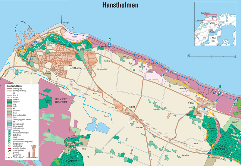
A detailed map of Hanstholm. From the brochure "Vandreture nr. 118. Hanstholmen", updated January 2005, published by the Danish Forest and Nature Agency. The dashed lines indicate a very steep slope, the former coastline.
Licencia
Under the case number "J.nr. SN 2001-0650-0003", where Lars Dybdahl requested permission to use this map with Wikipedia, the case was handled by the responsible person Pia Bøttiger Andersen from the Danish Ministry of the Environment, on the date 2005-12-20. The response was, that the Danish Forest and Nature Agency has permitted the use of this map for general use, as long as a reference to the source is given. This is an example of such a reference is in Danish:
- Fra Skov- og Naturstyrelsens folder "Vandreture nr. 118. Hanstholmen (opdateret januar 2005).
This translates into:
- From the Danish Forest and Nature Agency brochure "Vandreture nr. 118. Hanstholmen" (updated January 2005)
The official homepage of the agency is: www.skovognatur.dk Official email address of the agency is: sns@sns.dk
- Eres libre:
- de compartir – de copiar, distribuir y transmitir el trabajo
- de remezclar – de adaptar el trabajo
- Bajo las siguientes condiciones:
- atribución – Debes otorgar el crédito correspondiente, proporcionar un enlace a la licencia e indicar si realizaste algún cambio. Puedes hacerlo de cualquier manera razonable pero no de manera que sugiera que el licenciante te respalda a ti o al uso que hagas del trabajo.
- compartir igual – En caso de mezclar, transformar o modificar este trabajo, deberás distribuir el trabajo resultante bajo la misma licencia o una compatible como el original.
Historial del archivo
Haz clic sobre una fecha y hora para ver el archivo tal como apareció en ese momento.
| Fecha y hora | Miniatura | Dimensiones | Usuario | Comentario | |
|---|---|---|---|---|---|
| actual | 17:45 27 jun 2006 | | 2260 × 1557 (1,14 MB) | Igiveup | == Summary == Source: http://en.wikipedia.org/wiki/Image:Hanstholmen-map.png A detailed map of Hanstholm. From the brochure "Vandreture nr. 118. Hanstholmen", updated January 2005, published by [http://www.sns.dk/ the Danish Forest and Nature Agency]. T |
Usos del archivo
No hay páginas que enlacen a este archivo.
Uso global del archivo
Las wikis siguientes utilizan este archivo: